

8 P.M. SUN: FELICIA 435 MILES ENE OF HILO, WINDS 50 MPH 8/9/09
(Updated at 8:00 p.m. HST Sun August 9, 2009)
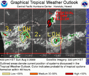
TROPICAL STORM FELICIA INTERMEDIATE ADVISORY #26A
Felicia continues on a path towards the Hawaiian Islands.
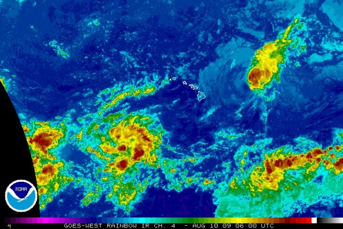
(Click to enlarge image. Satellite image courtesy NOAA, & The National Hurricane Center)
A tropical storm watch remains in effect for Oahu, the Big Island of Hawaii, and for all of Maui County, including the islands of Maui, Molokai, Lanai, and Kahoolawe. A tropical storm watch means that tropical storm conditions are possible within the watch area, generally within the next 36-48 hours.
At 8 p.m. HST Sunday, August 9, 2009, the center of Felicia was about 435 miles east-northeast of Hilo Hawaii and about 605 miles east of Honolulu Hawaii (Longitude 148.5 West, and Latitude 21.0 North).
Felicia is moving to the west at near 14 mph, and this motion is expected to continue for the next couple of days. The center of Felicia is expected to be near or over the Hawaiian Islands by late Monday or early Tuesday.
Maximum sustained winds are near 50 mph, with higher gusts. Gradual weakening is foecast during the next couple of days. Felicia could still reach the Hawaiian Islands as either a tropical depression or tropical storm.
Tropical storm force winds extend outward up to 115 miles from the center.
The air reconnaissance measured a minimum central pressure of 1003 mb or 29.62 inches.
Even though Felisia is still east of the Hawaiian Islands, a building swell generated by the tropical cyclone has already reached the East facing shores of the Big Island. This large swell will begin to impact the remaining Hawaiian Islands tonight and tomorrow.
 Regardless of the strength of Felicia when it reaches the Hawaiian Islands, heavy rains are still expected to occur and flash flooding remains a possibility.
The next advisory will be issued by the Central Pacific Hurricane Center at 11 p.m. HST 8/9/09.
(Updated @ 8:00 p.m. Sunday 8/9/09 by Wendy Osher; Information provided by Forecaster Houston with the NWS, Central Pacific Hurricane Center.)
Sponsored Content


