

FELICIA LOCAL STATEMENT: WHERE & WHEN TO EXPECT RAIN
(Updated: 6:17 p.m. HST Monday, August 10, 2009 by Wendy Osher)
FELICIA LOCAL STATEMENT
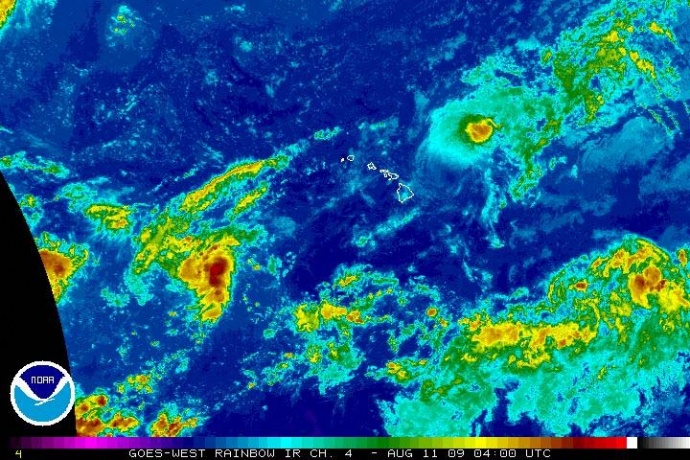
(Click to enlarge image. Satellite imagery courtesy NOAA & The National Hurricane Center. Image updated at 6p hst 8/10/09)
Gusty winds and shower bands from Felicia will begin spreading across Maui County later tonight with the center passing very near Maui County Tuesday afternoon and Oahu Tuesday night.
WATCHES/WARNINGS:
A tropical storm watch continues for Oahu, Molokai, Lanai, Kahoolawe, Maui, and adjacent coastal waters.
- WINDS:Â Gusty northeast winds will increase over Maui County late tonight as Felicia approaches…becoming northwest at 20 to 35 mph with gusts to 45 mph on Tuesday afternoon. Variable winds of 20 to 35 mph with local gusts to 45 mph will continue into Tuesday night as Felicia moves through.
- STORM SURGE AND STORM TIDE:Â A high surf warning is in effect through 6 pm Tuesday along east facing shores of Molokai and Maui. Surf will continue to rise…reaching or exceeding the warning criteria of 15 feet through Tuesday.
- INLAND FLOODING:Â Bands of showers associated with Felicia will be reaching Maui County late tonight or early Tuesday. Showers will likely become more frequent and heavier during the day on Tuesday as the system moves through. There is still the chance for heavier downpours to become anchored over terrain which could lead to flash flooding. A flash flood watch continues for Maui County through Wednesday afternoon.
- MARINE:Â Seas over the Maui county coastal waters will increase further as Felicia approaches…possibly reaching heights of 12 to 15 feet Tuesday. Rough…dangerous seas will continue Tuesday night into Wednesday…especially for east facing exposures.

State and County officials are briefed on the track of Felicia at a briefing on Sunday at the County Emergency Operating Center. Photo Courtesy: County of Maui.
Flash flood watch continues for Oahu from Tuesday morning though Wednesday afternoon.
Flash flood watch continues for Kahoolawe, Lanai, Maui, and Molokai through Tuesday afternoon.
High surf warning for east facing shores of Oahu, Molokai and Maui until 6 pm Tuesday.
STORM INFORMATION:
At 5 pm HST, the center of tropical storm Felicia was located near latitude 20.9 north…longitude 152.1 west…or about 210 miles east-northeast of Hilo, Hawaii. The system is moving west or 270 degrees at 10 mph. Maximum sustained winds are near 40 mph.
SITUATION OVERVIEW:
A weakening tropical storm Felicia is forecast to continue moving westward…with the center passing very near Maui County Tuesday afternoon and Oahu Tuesday night. By the time Felicia reaches the islands…it is expected to weaken to a tropical depression. However…there is still a slight chance that the system could be a tropical storm when it reaches the islands…and so a tropical storm watch remains in effect.
Even if Felicia weakens to a depression…it could still produce pockets of heavy rainfall and flash flooding…as well as localized strong gusty winds. The strongest winds can be expected near higher terrain which can accelerate winds down slope.
PRECAUTIONARY/PREPAREDNESS ACTIONS:
Secure loose outdoor objects that could be blown around by strong winds…or bring them indoors this evening. Have batteries and flashlights on hand in case the power fails.
People in flood prone areas should prepare in case heavy rainfall materializes.
Interests at ports…docks…and marinas should prepare now. If you live on a boat…begin to safely secure your craft and make plans to leave it for adequate land based shelter. Listen for possible warnings.
Small craft should return to port or seek safe harbor.
Monitor NOAA weather radio and local news outlets for official storm information. Listen for possible changes to the forecast.
(Updated: 6:17 p.m. HST Monday, August 10, 2009 by Wendy Osher; information provided by Forecasters: BRENCHLEY & R BALLARD from the NWS Central Pacific Hurricane Center)
Sponsored Content


