

Maui Tsunami Evacuation Maps Updated
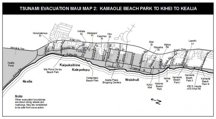
One of several updated tsunami evacuation maps. This one depicts evacuation zones for part of the South Maui area. Image courtesy County of Maui. Click image to view in greater detail.
By Wendy Osher
Updated tsunami evacuation maps have been released by the Maui County Civil Defense Agency.
Authorities say the maps were updated based on newly-released scientific data from UH geophysicists, and include expanded evacuation areas in Kahului, Kīhei, and Lahaina.
Maps were also created for Kahakuloa Village and the East Maui community of Keʻanae which had not previously been mapped, according to county officials.
The Keʻanae map includes the evacuation of property in the Keʻanae peninsula up to 300 feet below the Hāna Highway off of Keʻanae Road.
The Kahakuloa map includes the evacuation of properties along Waihali Gulch makai of the Kahekili Highway, and along the Kahakuloa Stream extending 450 feet mauka of the roadway.
The Maui County Civil Defense Agency and government officials are urging all Maui County residents to review the new evacuation maps to familiarize them with areas that they work and live.
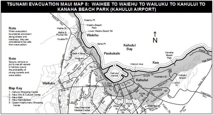
One of several updated tsunami evacuation maps. This one depicts evacuation zones for part of the Central Maui area of Kahului. Image courtesy County of Maui. Click image to view in greater detail.
“Please check the updated maps carefully because they mean that some households that were not instructed to evacuate during past tsunami warnings may now be included in the evacuation zone,” Maui Mayor Alan Arakawa advised in a county issued press release.
“This new information will help us as a community to be better prepared for a tsunami, and I encourage everyone to share these maps with family, friends and neighbors,” he said.
Civil Defense Emergency Management Officer Anna Foust said the new inundation models take into account the bathymetry, or topography, of the ocean floor around the islands and how that impacts the tsunami wave as it reaches the shoreline.
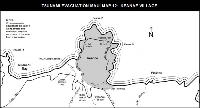
One of several updated tsunami evacuation maps. This one depicts evacuation zones for Keʻanae, which were previously unmapped. Image courtesy County of Maui. Click image to view in greater detail.
She encouraged the public to review the recent changes online noting that the updated maps will be included in next year’s phone books.
Community meetings in each district are also being planned by the Maui Civil Defense Agency to introduce the maps to residents and discuss how they can prepare for a tsunami and other hazards.
The maps can be found by clicking on the “Tsunami Evacuation Maps” tab, located in the left menu bar on the Maui County Civil Defense webpage at the following URL: www.mauicounty.gov/CivilDefense.
***Supporting information courtesy County of Maui.
Sponsored Content


