

5.3 Hawaiʻi Island Quake Felt on Maui, No Tsunami
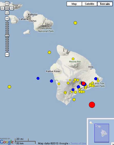
5.6 Hawaiʻi Island earthquake, 2:13 p.m. June 4, 2013. Map courtesy Hawaiian Volcano Observatory and Google Maps.
By Wendy Osher
There is no tsunami expected following a 5.3 magnitude earthquake reported in the deep ocean southeast of Hawaiʻi Island at 2:13 p.m. on 6/4/13, according to information released by the Pacific Tsunami Warning Center.
The magnitude of the quake was upgraded from a preliminary 5.2 to a 5.6 after further evaluation, and then downgraded again to a 5.3 upon further review by the USGS.
According to the USGS, the quake was centered 34 miles SE of Pahala; 47 miles S of Hawaiian Paradise Park; 56 miles S of Hilo; 78 miles SE of Kailua-Kona; and 245 mile SE of Honolulu.
The agency reports that the depth of the quake was 40.9 km.
Although the quake was centered in the ocean off of Hawaiʻi Island, residents in various parts of Maui including Kahului and Lahaina reported feeling shaking during the event. There was also a few reports from individuals who said they felt the quake as far away as Oʻahu, according to information released by the USGS.
The USGS received more than 400 felt reports within the first hour of the earthquake from residents reporting they had felt the quake.
According to Wes Thelen, Hawaiian Volcanoes Observatory’s Seismic Network Manager, the earthquake was located 12 miles east of Lo`ihi, but does not appear to be associated with the submarine volcano. The information was included in information provided by the USGS on Tuesday afternoon.
“The earthquake was most likely a structural adjustment of the Earth’s crust due to the weight of Hawai‘i Island on the underlying mantle,” he said in a USGS press release this afternoon.
Agency officials released information saying seismic records show that another earthquake of similar magnitude and depth occurred in this same general area in 2005.
The earthquake had no apparent effect on Kilauea’s ongoing eruptions according to a statement provided by HVO geologist Tim Orr. “HVO monitoring networks have not detected any significant changes in activity at the summits or rift zones of Kilauea or other Hawaiian volcanoes,” said Orr.
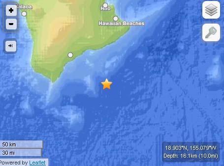
Hawaiʻi Island Quake, June 4, 2013. Map imagery courtesy USGS/ powered by Leaflet.
Sponsored Content


