

Henriette Weakens to a Remnant Low
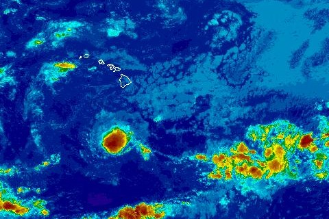
TD Henriette 8/11/2013. Satellite imagery courtesy CPHC/NOAA/NWS.
By Wendy Osher
(Update: 11 a.m. 8/11/13)
Henriette has weakened to a post-tropical remnant low, ending the forecast advisories issued by the Central Pacific Hurricane Center for the system.
At 11 a.m., Henriette was tracked passing several hundred miles south of the Hawaiian Islands.
The CPHC tracked the system at: 485 miles SSW of Hilo; 460 miles SSW of Kailua-Kona; 415 miles SSW of South Point; 530 miles SSW of Kahului; 530 miles S of Kaunakakai; 515 miles SSW of Lanai City; 540 miles S of Honolulu; 580 miles S of Lihue; and 590 miles S of Niihau.
Maximum sustained winds were 35 mph, with present movement toward the west at 22 mph, according to the CPHC forecast.
Agency officials say the remnant low will continue to weaken over the next day or two until dissipation occurs.
Forecasters are also tracking an area of low pressure located about 1,400 miles ESE of the Big Island of Hawaiʻi.
The CPHC issued an update stating that the trough continues to produce disorganized showers and thunderstorms. Any development, forecasters say, is expected to be slow to occur during the next few days as it continues on a past westward at 10 to 15 mph.
The CPHC forecast says that this system has a low, 10% chance of becoming a tropical cyclone during the next two days.
(Update: 5 a.m. 8/11/13)
Henriette has weakened to a Tropical Depression and continues on a path west and well south of the state, according to the latest information released by the Central Pacific Hurricane Center.
As of 5 a.m., Henriette was located 425 miles S of Hilo; 420 miles S of Kailua-Kona; 365 miles S of South Point; 505 miles S of Kahului; 520 miles S of Kaunakakai; 500 miles S of Lānaʻi City; 545 miles SSE of Honolulu; 610 miles SSE of Līhuʻe; and 630 miles SSE of Niʻihau, according to the CPHC.
Forecasters with the CPHC say the system had sustained winds of 35 mph and was moving west at 23 mph.
Current movement is forecast to continue until the system dissipates late Monday night, according to the CPHC forecast.
Forecasters are also tracking an area of low pressure located about 1,400 miles ESE of the Big Island of Hawaiʻi.
The CPHC issued an update stating that the trough continues to produce disorganized showers and thunderstorms. Any development, forecasters say, is expected to be slow to occur during the next few days as it continues on a past westward at 10 to 15 mph.
The CPHC forecast says that this system has a low, 10% chance of becoming a tropical cyclone during the next two days.
(Update: 11 p.m. 8/10/13)
Tropical Storm Henriette continues to weaken and was last located 425 miles S of Hilo; 530 miles SSE of Kahului; 560 miles SSE of Kaunakakai; and 535 miles SSE of Lānaʻi City The system is on a path west moving at 21 mph, and well south of the Hawaiian Islands. Maximum sustained winds were at 40 mph, with higher gusts. Forecasters from the NWS say Henriette is expected to become a post-tropical remnant low by Monday night and dissipate by Tuesday night.
Sponsored Content


