

Malika Dudley’s Halloween Maui County Forecast
By Meteorologist Malika Dudley / Email: [email protected]
**A breakdown of expected conditions specific to Maui County is presented below in graphical form. All graphics are provided by the National Weather Service in Honolulu.**
Alerts
The National Weather Service has continued the HIGH SURF ADVISORY for east shores of Molokai and Maui until 6 a.m. Saturday, Nov. 1, 2014. Hazardous ocean conditions are expected due to a combo of north swell and increasing winds. Watch out for rip currents, dangerous shore break conditions and strong breaking waves.
A SMALL CRAFT ADVISORY is posted for the Pailolo Channel, Māʻalaea Bay and Maui County windward waters until 6 a.m. Saturday, Nov. 1, 2014. Rough seas are expected from 8 to 12 feet. Winds are forecasted out of the northeast at 25 to 30 knots, with gusts up to 35 knots. Inexperienced mariners are cautioned to avoid navigating in these conditions.
Today
We expect partly cloudy skies for leeward areas today with scattered showers. Windward and mauka areas are forecasted to get mostly cloudy skies with frequent showers. High temperatures should fall in the range of 82° to 87° with higher elevations experiencing lower temperatures overall. Generally we expect trade winds from 15 – 25 mph with higher gusts.
Sunrise: 6:28 a.m.
Sunset: 5:51 p.m.
UV index at 7 (“high” exposure level)
Halloween Night
Tonight we expect breezy winds and cloudy conditions. We should get trade winds from 15 to 25 mph, with higher gusts. On and off showers are likely for leeward areas while frequent showers are forecasted for windward and mauka spots. Low temperatures should fall in the range of 72° to 77° with a high of about 71° at 5000 feet. Here is a breakdown of the forecast for Maui County’s many zones.
Kīhei/Mākena – Partly cloudy, 20% chance of isolated showers, winds 15 – 20 mph
Windward including Hāna/Makawao – Mostly cloudy, 80% chance of showers, 15 – 25 mph
Central Maui – Partly cloudy, 20% chance of isolated showers, winds 15 – 20 mph
Leeward West side including Lahaina – Partly cloudy, 50% chance of scattered showers, winds 15 – 20 mph
Windward West side including Wailuku – Mostly cloudy, 70% chance of showers, winds 15 – 20 mph
Lānaʻi City – Partly cloudy, 30% chance of scattered showers, winds 15 – 20 mph
Molokaʻi windward – Mostly cloudy, 80% chance of showers, winds 15 – 25 mph
Molokaʻi leeward – Mostly cloudy, 50% chance of scattered showers, winds 15 – 20 mph, 35 mph gusts
Moonrise: 1:25 p.m.
Moonset: 1:20 a.m.
Next Full Moon: Nov 6, 2014 at 12:23 p.m.
Next New Moon: Nov 22, 2014 at 2:33 a.m.
Looking Ahead
Lingering moisture from a dissipating front is expected to affect mainly windward and mauka spots through the weekend. Some of those showers could pass leeward from time to time. Trade winds are expected to weaken over the weekend. Another front is expected to affect us next week. Ahead of the front winds are forecasted to shift out of the east-southeast. By midweek trade winds are expected to build back in.
Surf & Seas
North: Surf is expected in the head high to overhead range with sets up to 2 to 3 feet overhead at the best breaks exposed to the swell. Late in the day some spots could get double overhead sets.
West: Breaks that don’t catch the NNW or SSW swells are forecasted to get smaller surf in the ankle to knee high range. Spots that are open to the swell should see head high to overhead waves with sets up to 2 to 3 feet overhead at the best breaks. Late in the day some spots could possibly get double overhead sets.
South: Ankle-slappers to possibly waist high surf is expected. Generally the farther south you go, the bigger the waves. The best southern exposures could see waves in the waist to chest high range.
Our current north-northwest swell (340-360°) will fade throughout the day. Another reinforcing swell is expected to fill in, peaking late in the day through early Saturday morning at a couple feet overhead. This swell is expected to fade out starting late Saturday. A new northwest swell (305-325°) is expected by midweek.
A nice sized trade wind swell is affecting our eastern shores which are under a high surf advisory at this time. Sloppy, choppy conditions are expected for northeast shores.
Our current south-southwest swell (200-180°) is fading out today and into the weekend. A reinforcing swell (200-185°) is expected over the weekend, peaking in the knee to waist high range Saturday into Sunday morning before fading out. After that swell subsides, surf goes quiet with not much on the horizon out of the South Pacific.
Keep in mind, surf heights are measured on the face of the wave from trough to crest. Heights vary from beach to beach, and at the same beach, from break to break.
Almanac for Kahului Airport
Maximum Temperature for today:
Normal 86°
Record 92° / Set in 1950 and tied in 1972 and 1994
Minimum Temperature for today:
Normal 69°
Record 60° / Set in 1950

Ho’okipa Rainbow / Image: Jimmie Hepp
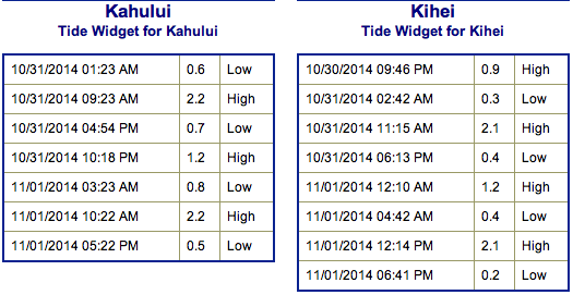
Tides on Friday October 31, 2014 / Image: NOAA / NWS
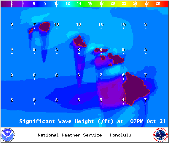
Surf heights at 4pm on Friday October 31, 2014 / Image: NOAA / NWS
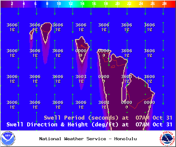
Swell 1 on Friday October 31, 2014 / Image: NOAA / NWS
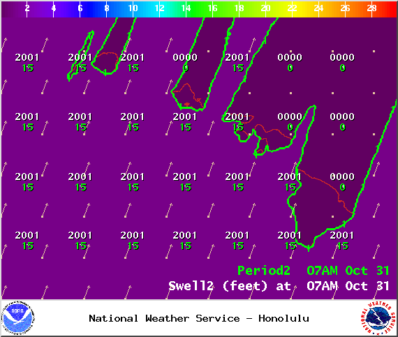
Swell 2 on Friday October 31, 2014 / Image: NOAA / NWS
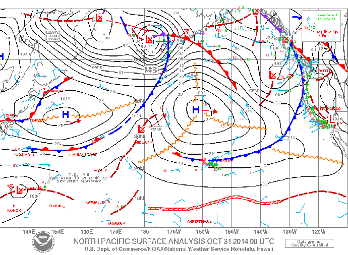
Surface map on Friday October 31, 2014 / Image: NOAA / NWS
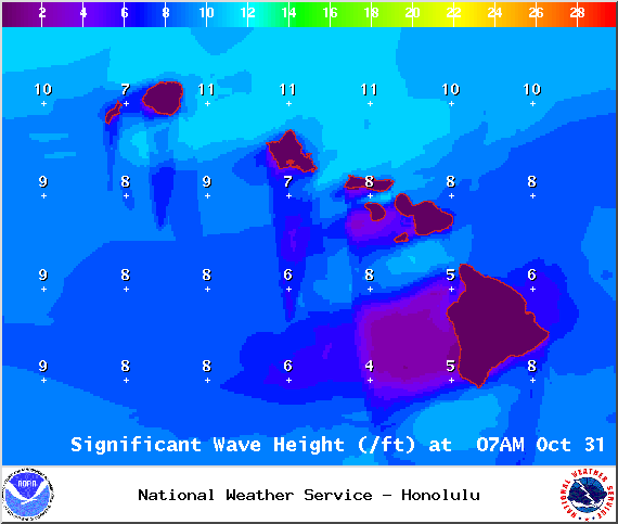
Surf heights at 7am on Friday October 31, 2014 / Image: NOAA / NWS
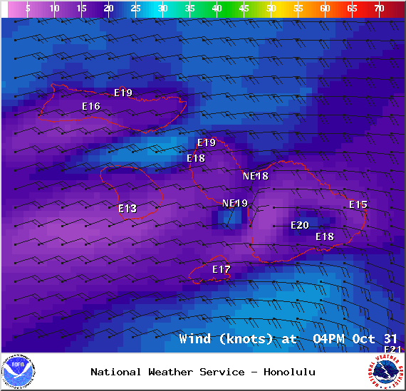
Wind Conditions at 4pm in Maui County on Friday October 31, 2014 / Image: NOAA / NWS
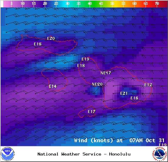
Wind Conditions at 7am in Maui County on Friday October 31, 2014 / Image: NOAA / NWS
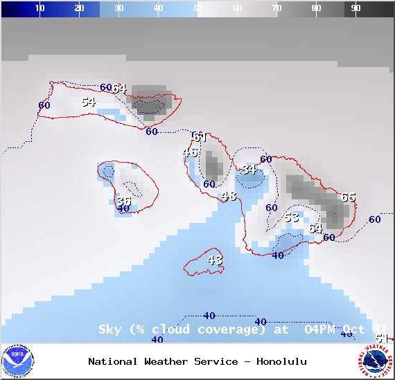
Chance of cloud cover at 4pm in Maui County on Friday October 31, 2014 / Image: NOAA / NWS
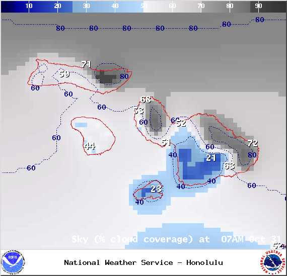
Chance of cloud cover at 7am in Maui County on Friday October 31, 2014 / Image: NOAA / NWS
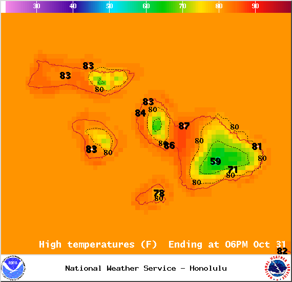
Map of expected high temperatures in Maui County on Friday October 31, 2014 / Image: NOAA / NWS

Map of expected overnight low temperatures in Maui County on Friday October 31, 2014 / Image: NOAA / NWS
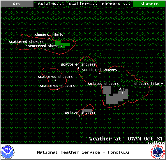
Expected weather conditions at 7am in Maui County on Friday October 31, 2014 / Image: NOAA / NWS
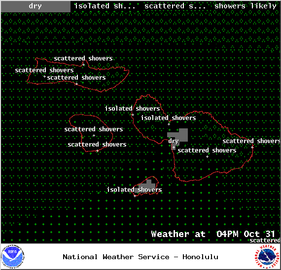
Expected weather conditions at 4pm in Maui County on Friday October 31, 2014 / Image: NOAA / NWS
Sponsored Content


