UPDATE: Tropical Storm Ela to Bring Muggy Weekend Weather
 By Maui Now Staff
UPDATE:
Thursday, 2 p.m.
There are no significant changes from the last report (below). Changes include the following:
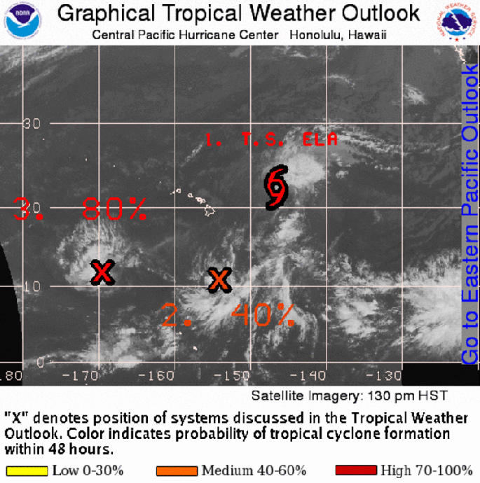
Tropical Storm Ela is located about 545 miles east-northeast of Hilo.
Showers and thunderstorms located about 620 miles south of Hilo are associated with a small area of low pressure. Some signs of low-level organization have been observed. Upper level winds are conducive for additional slow development over the next 48 hours with a 40% probability of formation.
 ORIGINAL POST AT 8 a.m. Thursday, July 9
The storm formerly known as Tropical Depression Four-E gained enough strength to reach tropical storm status, according to the Central Pacific Hurricane Center in its 11 p.m. update Wednesday.
On Thursday, July 9, at 8 a.m. CPHC released at update on Tropical Storm Ela.
Tropical Storm Ela, now located about 575 miles east of Hilo, is expected to weaken and pass north of the state over the weekend.
Showers and thunderstorms located about 600 miles south of Hilo are associated with an area of low pressure. Although environmental conditions are not conducive for significant development of this system, some slow development will remain possible during the next two days with a 20% chance of formation over the next 48 hours.
The NWS update at 4 a.m. this morning stated that trade winds will remain breezy today as high pressure resides far north of the state. Low clouds and passing showers will favor windward and mauka areas and may reach the lee areas of the smaller islands at times.
Trade wind weather will continue across the state early Thursday morning, with a slight increase in low clouds in the island vicinity compared to last night.
The latest satellite imagery revealed a broader area of low clouds further upstream east of the state. These clouds will probably reach the state later today, bringing more passing showers to the islands.
The subtropical high pressure far north of the state will persist through rest of the week into next week.
Trade wind weather will continue across the islands today through much of Friday, with passing low clouds and showers affecting mainly windward and mountain areas. Winds will remain strong enough to carry a few showers to select lee areas of the smaller islands today.
As Tropical Storm Ela advances closer to the islands, winds will decrease on Friday and turn more northerly.
Ela is expected to track and stay north of the state late Friday through the weekend and weaken, disrupting the trade winds in the island vicinity during that time period. The large area of tropical moisture associated with the system will be dragged across the state over the weekend, resulting in muggy weather Saturday and Sunday with light winds. More showers and clouds are expected for the weekend as well, as the very moist and unstable air mass spread across the area into early Monday.
There will be a threat for locally heavy showers and a slight chance of thunderstorms, mainly for Saturday afternoon and Sunday afternoon through early Monday. Since it is hard to pin point which areas are more susceptible, have continued the wide coverage of the potential unsettled weather across the state in this forecast package.
The trades are expected to build back by early Monday, and may carry another band of moisture affecting the state, bringing more showers. In fact, forecast models hint moist air mass may reach the islands at times throughout next week. A strong surface high will persist far north of the islands much of next week, maintaining moderate trade winds to the state. Thus, wet trade wind weather is expected for the islands next week.
Sponsored Content