

Latest Guillermo Update
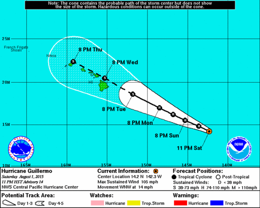
Image: NHC 11 p.m. updated track
By Meteorologist Malika Dudley / Email: [email protected]
11 p.m. UPDATE
Hurricane Guillermo is now in the Central Pacific and 1035 miles ESE of Kahului, 1090 miles ESE of Kaunakakai and 1065 miles ESE of Lanai City. The entire island chain is now within the forecast cone. Otherwise, speed (WNW at 14 mph) and strength (105 mph) remains relatively constant.
Slow weakening is still expected into early next week but Guillermo is likely to remain at hurricane strength through Monday. Hurricane force winds extend outward up to 10 miles from the center and tropical storm force winds extend up 140 miles from the center.
A high surf advisory for the east facing shores of most islands is slated to go into effect at noon Sunday for a building swell generated by Guillermo. We expect the surf to reach advisory level by Sunday night. This advisory will likely stay in effect through most of the week with Guillermo nearby. The advisory may be raised to warning level depending of the strength of Guillermo.
Guillermo is forecast to be a tropical storm as it nears the islands with further weakening expected as it moves westward. Clouds, showers and wind are expected to spread to the Big Island Tuesday night. Rainy and somewhat windy weather are expected to spread to the other islands through Thursday evening. This is all subject to change based on the eventual track and intensity of Guillermo as it continues to approach.

Image: NHC 5 p.m. updated track
5 P.M. UPDATE – There has not been much change in the forecast reasoning, track and intensity. Guillermo is now 1005 miles ESE of Hilo, 1065 miles ESE of Kailua-Kona and 1030 miles ESE of South Point. Air Force Hurricane Hunters are scheduled to begin reconnaissance missions Sunday morning.
The National Weather Service reminds residents that it’s important not to focus too closely on the exact forecast track of Guillermo. With an average 96 hour track error of just over 200 statute miles and a 120 hour forecast error of nearly 300 miles, it is still too soon to determine with any certainty which islands would be most likely to experience the greatest impacts from Guillermo. It is also important to note that significant impacts from tropical cyclones can extend well away from the center.
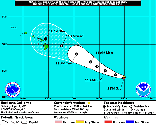
Image: NHC 11 a.m. updated track
11 A.M. UPDATE – Not much has changed with Guillermo’s intensity since the last update. The track has been modified slightly. Guilermo is now moving into the Central Pacific and the the Central Pacific Hurricane Center will take over monitoring the system. The most reliable track models are now in better agreement bringing Guillermo just north or very near the Hawaiian Islands.
GUILLERMO STATS (8 a.m. 8/1/15)
Category 2 Hurricane
Maximum sustained winds: 105 mph
Hurricane force winds extend 25 miles from the center
Tropical storm force winds extend 140 miles from the center
Moving W at 14 mph
1255 miles ESE of Kahului
1310 miles ESE of Kaunakakai
1275 miles ESE of Lanai City
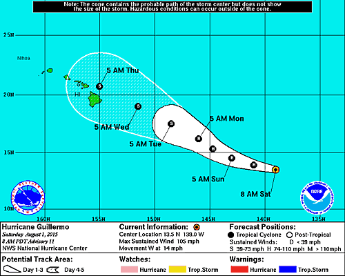
Image: NHC
Storm track and intensity:
Guillermo is not looking as impressive on satellite this morning. Yesterday we had a hint of eye but today it looks like the system has already reached its peak and is on a downward trend with regards to intensity as well as forward motion. The NHC anticipates the storm will remain steady over the next 12 hours or so then begin to gradually weaken. By the time the system gets near the Hawaiian Islands we expect it to be a tropical storm.

Image: NHC
Weather models are not in agreement as to where the system will end up going. One model shows Guillermo going north of the islands and the other brings it to the south or near the islands.Because the track is so uncertain we cannot say for sure what the effects will be to the Hawaiian Islands and will continue to keep a close eye on the situation.
**Remember: Tropical systems like these are very unpredictable. We always hope for the best but prepare for it just in case. It’s always best to prepare now.**
Sponsored Content


