

Hilda Major Hurricane, Track Shifted Toward Islands

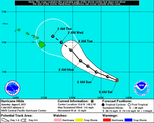
11 p.m. CPHC track Hilda
By Meteorologist Malika Dudley / Email: [email protected]
(11 p.m. Update)
Hilda’s track on days 4 and 5 is now veering west more sharply. Error in the track that far out can still be hundreds of miles but it’s still important to note that the current forecast track does include the Big Island and most of Maui County.
Hilda has weakened a bit since the last update with maximum sustained winds now at 125 mph. However, it is expected to still be a major hurricane for the next 24 hours or so. Strengthening is possible but the forecast isn’t calling for this. A steady weakening trend is expected early Monday. On days 4 and 5 of the forecast the latest models are calling for less aggressive weakening.
The system is moving WNW at 12 mph.
(5 p.m. Update)
Over the last few hours Hilda seems it may have peaked in intensity.
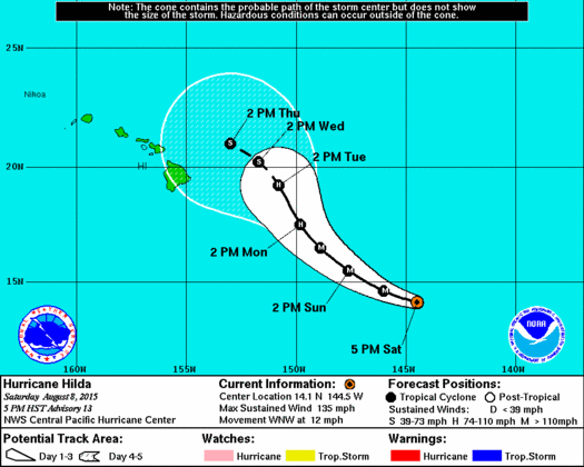
Hilda track 5 p.m. August 8, 2015
The system is still a Category 4 hurricane but maximum sustained winds are a bit lower at 135 mph with higher gusts. Some fluctuations in strength are possible today with a rapid weakening trend to start on Sunday.
The storm, located 915 miles ESE of Kahului, 965 miles ESE of Kaunakakai and 940 miles ESE of Lanai City, continues to move WNW at 12 mph. A gradual turn to the northwest and a decrease in speed are expected through early Monday.
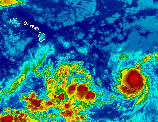
NWS satellite Hilda now Category 3 hurricane – 5 a.m. August 8 2015
Hurricane force winds extend just 25 miles from the center and tropical storm force winds extend outward up to 125 miles.
(11 a.m. Update)
Hilda has rapidly intensified over the last 24 hours and is now a Category 4 system with maximum sustained winds at 140 mph. Hurricane force winds extend 25 miles from the center, and tropical storm force winds extend 125 miles.
(5 a.m. Update)
As of the Central Pacific Hurricane Center’s 5 a.m. update, Hilda has become a Category 3 hurricane. Maximum sustained winds are now at 115 mph with higher gusts. Some strengthening is forecasted through tonight with a weakening trend to start on Sunday. The system crossed into the Central Pacific overnight.
The storm, located 1060 miles ESE of Kahului, 1115 miles ESE of Kaunakakai and 1090 miles ESE of Lanai City, continues to move W at 15 mph.
NWS satellite Hilda now Category 3 hurricane – 5 a.m. August 8 2015
A gradual turn to the northwest and a decrease in speed are expected through early Monday.
Hilda is still quite compact and small, but as the system intensifies it is also growing some in size. Hurricane force winds extend just 25 miles from the center and tropical storm force winds extend outward up to 90 miles.
On satellite, Hilda’s eye is clear to the naked eye. The system is expected to be over warm seas without significant vertical wind shear. This is expected to lead to some additional strengthening over the next 24 hours. After about 48 hours, increasing shear and slightly cooler sea surface temperatures should help to weaken the storm.
Sponsored Content


