Update 5 p.m. Hilda Downgraded to Post-Tropical Remnant Low
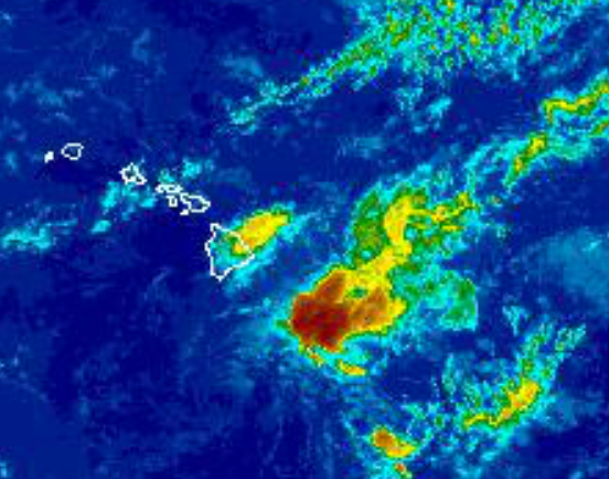
Image: NWS satellite 5 p.m. August 13, 2015
By Meteorologist Malika Dudley / Email: [email protected]
(Updated at 5 p.m.)
A Flood Advisory is still posted for parts of the Big Island at this hour even as Hilda continues to weaken. The smaller islands in Maui County will be somewhat north of the deeper moisture, and north of the best low level convergence, so heavy showers are no longer expected in those areas.
The track continues to shift south and the remnant low is moving west-southwest near 14 mph and this motion is expected to continue through Friday night before dissipation on Saturday. Maximum sustained winds are at 30 mph with higher gusts.
The system is currently 345 miles S of Hana, 355 miles S of Kahului, 375 miles S of Kaunakakai and 350 miles S of Lanai City. This will be the last update from the Central Pacific Hurricane Center on Hilda unless re-generation occurs (which is not likely).
Moisture surrounding tropical depression Hilda will continue to bring a chance of heavy thundershowers to the Big Island tonight and Friday. As Hilda moves away later Friday, showers will diminish.
Trades are expected to keep blowing through Saturday. A trough will pass near the islands late in the weekend and early next week. The trough will weaken our trades again, bringing another spell of uncomfortably warm and humid weather along with a chance of locally heavy mainly afternoon showers.

Image: CPHC 11 a.m. track Tropical Depression Hilda
(Updated at 11 a.m.)
Hilda has been downgraded to a tropical depression, as of the Central Pacific Hurricane Center’s 11 a.m. storm advisory.
Tropical Depression Hilda has picked up forward speed slightly since earlier Thursday advisories, but the increase to 12 mph was expected.
Forecasts predict that Tropical Depression Hilda will continue its weakening through Satuday as the storm continues to the south. As that occurs, a large area of moist air is forecast to bring showers over the islands. All the ingredients seem to be there for a heavy rain event, although not as extreme as what the guidance was suggesting a couple of days ago when it looked like Hilda might stall closer to the state. Heavy thundershowers are within the realm of possibility, especially for the Big Island. A much smaller chance of thunderstorms exists for Maui County.
Tropical Depression Hilda is expected to cause weakened trades that will leave the air feeling humid over the weekend.
Surf swells will continue to produce advisory level surf along east and southeast facing shores on the Big Island, as well as Maui.
A High Surf Advisory is in effect for East facing shores until 6 p.m. Thursday, while a Small Craft Advisory is currently in effect until 6 p.m. Friday.

Image: NWS satellite 5 a.m. August 13, 2015
(Updated at 5 a.m.)
As of 5 a.m. Hilda was located about 325 miles southeast of Kahului, moving west at 9 miles per hour, an increase in forward speed from earlier advisories.
The Central Pacific Hurricane Center reports that the storm has weakened a bit with maximum sustained winds of 40 mph and is barely hanging onto its tropical storm status. The system is expected to continue to weaken Thursday and into Friday and will become a tropical depression once it dips below 39 mph winds. That is expected to occur this afternoon.
Image: CPHC track 5 a.m. August 13, 2015
Rainfall along the north portion of Tropical Storm Hilda is expected, as well as large swells that may produce high surf along east and southeast facing shores. A High Surf Advisory is currently in effect for east facing shores on Maui. A Flash Flood Watch is expected to go into effect Thursday morning at 6 a.m. for the Big Island. The Tropical Storm Warning for offshore waters from 40nm out to 240 nm has been reinstated.
Tropical storm force winds extend outward up to 60 miles. The moisture field reaches far beyond that and 4 to 8 inches of rain with isolated amounts up to 12 inches are still expected in some Big Island locations. Some of that moisture could make it to the smaller islands as well.
Image: CPHC track 5 a.m. August 13, 2015
Hilda will pass far enough to the south of the Hawaiian Islands to avoid direct impacts but the associated moisture plume north through east of the system may trigger heavy rainfall, flash flooding and mudslides across portions of the Aloha State.
Moisture associated with Hilda will clear the state on Saturday. A trough passing near the islands later in the weekend will cause trade winds to weaken and shift out of the east-southeast into early next week.
For today’s full weather forecast click here.
Sponsored Content