

Tropical Storm Conditions Possible This Weekend

Image: Chris Archer
Alerts (as of 1:00 a.m.)
A Tropical Storm Watch is posted for Maui County. A watch is issued 48 hours before the possible arrival of tropical storm force winds.
A Flash Flood Watch has been issued by the National Weather Service. It goes into effect late Friday night and will be posted through Sunday afternoon. Tropical Storm Darby is expected to continue approaching the Hawaiian Islands. The forecast is still highly dependent on the track and intensity of the system, however, there is a possibility for intense rainfall and flash flooding this weekend. East to southeast facing slopes are at greatest risk.
When rainfall episodes of this intensity occur, flooding could occur even outside of normal flood zones. Keep in mind, flooding on roadways can make driving very dangerous and roads impassable. Two feet of water is enough to sweep your car away. Debris can clog waterways. Never try to cross fast-flowing water on foot.
A High Surf Warning is also posted for the east facing shores of Maui from 6 a.m. Friday to 6 a.m. Sunday. Surf is forecast to build to 12 to 20 foot faces Friday with higher sets at the best exposures. Waves this big can cause coastal flooding and lead to dangerous ocean conditions. Powerful currents are also a concern and large breaking waves can impact harbor entrances and channels.
**Click directly on the images below to make them larger. Charts include: Maui County high/low forecasted temperatures, projected winds, projected localized weather conditions and expected wave heights.**
Looking Ahead
Tropical Storm Darby is approaching the Hawaiian Islands from the east over the next couple of days. The system could bring stormy weather this weekend. As Darby gets closer the peripheral moisture will affect windward areas first. More intense rain and wind is expected to follow as the system progresses.
There is still a lot of uncertainty with the forecast. Just slight changes to track and intensity can mean big differences in the forecast philosophy. We will continue to keep an eye on this and bring you firmer forecasts. For now, the Big Island will see the effects first. We will have to see how it interacts with the land, channeling between our islands, gap winds, etc… Keep in mind effects can be felt far from the center of the system. For example, tropical storm force winds extend more than 100 miles from the center and the cloud field is even bigger than that.
Before Darby passes, typical trade wind weather is forecast with clouds and showers for our usual windward and mauka spots, mainly overnight and into the morning. After Darby passes, winds are forecast to turn southeast with hot, humid conditions expected.
Today
Partly cloudy skies with scattered morning showers for windward spots and isolated showers for leeward areas. High temperatures from 84° to 89°. Winds will be out of the northeast from 15 mph to 25 mph.
UV index at 12 (“extreme” exposure level)
Tonight
Northeast winds are expected around 15 to 25 mph tonight. Partly cloudy with scattered showers in windward spots and isolated showers in lee areas. Low temperatures from 72° to 77°.
Our Maui Now Weather homepage always includes daily: Sunrise | Sunset | Moonrise | Moonset | Moon Phase | Live Weather Cams | 5-day Forecast | Current Temperature & Conditions
***Click here for your marine outlook and surf report.***
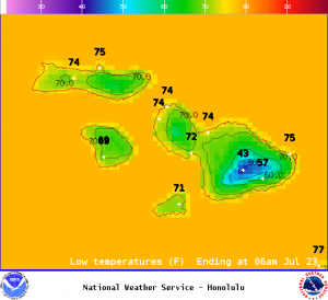
Image: NOAA
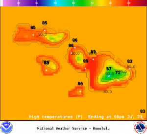
Image: NOAA
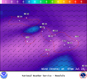
Image: NOAA
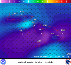
Image: NOAA
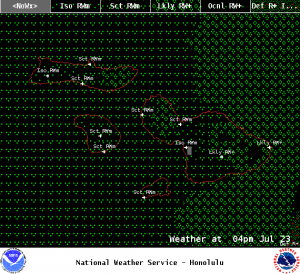
Image: NOAA
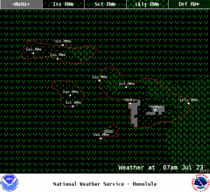
Image: NOAA
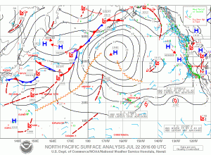
Image: NOAA
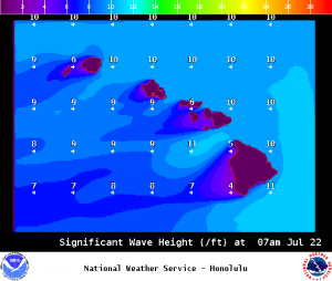
Image: NOAA
Sponsored Content


