How to Prepare if Irma, Harvey Hit Hawaiʻi
Earlier today, Hurricane Jose was upgraded to a Category 3 hurricane, making it the 3rd major hurricane of the 2017 Atlantic hurricane season.
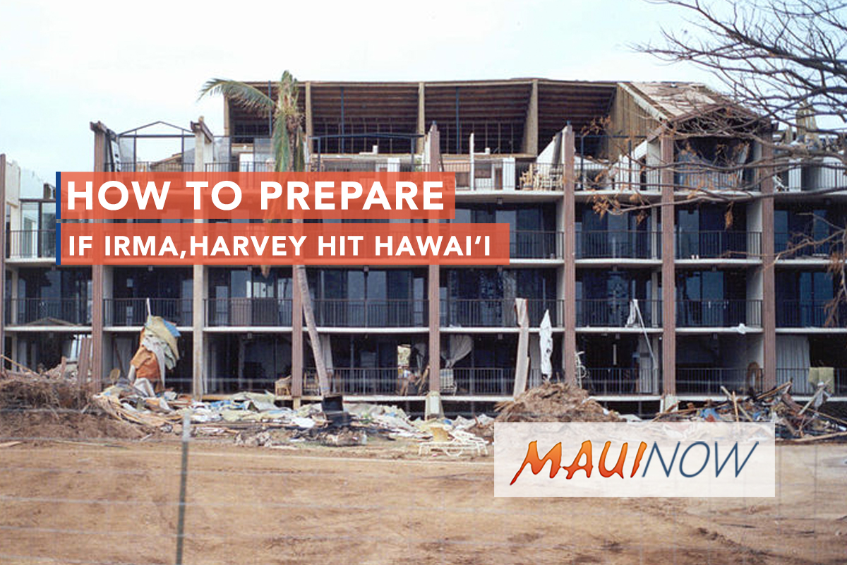
9/01/1992 — Nearly the entire roof has been blown off this multi-story apartment building during Hurricane Iniki. FEMA News Photo
Ahead of Jose, Destructive Hurricane Irma in the Atlantic continues on a path toward the west-northwest near 16 mph and has maximum sustained winds of 175 mph. The already deadly Category 5 hurricane blacked out much of Puerto Rico on Wednesday and is currently very near to Turks and Caicos.
On the forecast track, the eye of Irma should continue on a path towards the southeastern Bahamas by this evening and then be near the central Bahamas by Friday. Forecasters with the National Hurricane Center say some fluctuations in intensity are likely over the next day or two, but the system should remain a powerful Category 4 or 5 over the next couple of days.
NHC says it’s become more likely that Irma will make landfall in southern Florida as a dangerous major hurricane, bringing a life-threatening storm surge and wind impacts to much of the state. A hurricane watch is in effect for South Florida as of 5 p.m. EST, Sept. 7. County officials in Florida have already began mandatory evacuations.
A newly released Hurricane Irma forecast puts Miami in line for a direct hit around 2 p.m. on Sunday.
The forecast shows Jose could directly hit Barbuda late Friday into early Saturday. Barbuda was heavily damaged by Irma, officials in Barbuda say that at least 95% of the properties there were either totally destroyed or damaged.
All of this after Hurricane Harvey ripped through Texas on Aug. 25, leaving an estimated 70 people dead, with millions of families displaced and billions of dollars in damage.
Meantime, the Pacific Disaster Center here in Hawaiʻi has been assisting with analytical products and reports, helping to mitigate threats before they happen, and providing real-time information to emergency managers to protect vulnerable populations affected by Irma.
Sept. 11, 2017, will mark the 25th anniversary of Hurricane Iniki making landfall on Kauaʻi. Iniki hit Kauaʻi as a Category 4 hurricane, leaving six dead, thousands of homes destroyed, and close to $3 billion in damage.
Although hurricanes like Irma, Harvey, and Katrina are rare in Hawaiʻi, we’ve seen that it only takes one, like Iniki, to cause extensive damage to any island.
“Considering the devastation we saw from Iniki, as well as the more recent impacts from Hurricane Iselle and Tropical Storm Darby, make sure you and your family are prepared for hurricane season. Become weather-ready by signing up for weather alerts, developing and practicing a family emergency plan and restocking your emergency kit,” said Chris Brenchley, director of NOAA’s Central Pacific Hurricane Center.
The Hawaiʻi Emergency Management Agency recently updated its Emergency Preparedness Kit, now recommending residents prepare an emergency kit with a minimum of 14 days (previously 7) of food, water and other supplies.
Vern Miyagi, Hawaiʻi Emergency Management Agency Administrator, recommendeds putting together an emergency kit now and maintaining it throughout the hurricane season to avoid long lines at stores and gas stations shortly before and after a potential tropical storm event.
Hurricane season in Hawaiʻi began on June 1 and runs through November 30.
Hurricane Warning vs. Watch
– A hurricane is a tropical cyclone with winds of 74 mph or more. Torrential rains, destructive waves, and high waters known as a storm surge, may create flood conditions in coastal and low-lying areas. More lives are claimed by storm surge and flooding in most parts of the world than by the winds of a hurricane.
– A Hurricane Watch is issued by the NWS if hurricane conditions COULD POSSIBLY reach the islands within 48 hours.
– A Hurricane Warning is issued by NWS when dangerous hurricane conditions are expected to affect the islands WITHIN 36 HOURS OR LESS.
– Assemble an Emergency Kit – Keep family supplies in an easy-to-carry “Emergency Kit” that you can use at home or take with you in case you must evacuate.
UPDATED EMERGENCY KIT CHECKLIST FOR 2017:
– Water: one gallon per person, per day (14-day supply) This is for drinking and hygiene
– Food: non-perishable, easy to prepare items (14-day supply)
– Manual can opener
– Flashlight
– Battery-powered, solar, or hand-crack radio (NOAA weather radio, if possible)
– Extra batteries
– First Aid kit
– Swiss Army knife or multi-purpose tool
– Maps of the area
– Whistle, matches, blankets, tarps, duct tape, scissors
– Water cooler with wheels or a rolling cart
– Two-way radios
– Checkbook and extra cash for small bills (with no power, ATMs and credit cards will not work)
– Extra set of car keys and house keys
– Small backpack per family member with full change of clothes, sturdy shoes
– Sanitation and personal hygiene items
– Medical supplies and specialty items (heading aids with extra batteries, glasses, contacts, solution, syringes, etc.)
– Medications (14-day supply) and copies of prescriptions and dosages
– Baby supplies (bottles, formula, baby food, diapers, wipes, etc.)
– Pet supplies (collar, leash, ID, food, carrier, bowl, etc.)
– Family phone numbers and emergency contact information
– Cell phone with chargers
– Copies of personal documents in a sealed plastic bag (identification, bank account information, proof of address, deed/lease to home, birth certificates, passports, health/home/auto insurance information, etc.)
The Hawaii Red Cross website states “due to our isolation, we encourage all families to be prepared for 14 days instead of 72 hours. It will take time following a disaster for a logistics bridge to be built to Hawaii if our harbors and airports are affected by a major disaster and we may be relying on our own resources longer than other places within the United States.”
More helpful links to prepare:
Maui County Emergency Management Agency
Hawaiian Electric Emergency Preparedness Handbook
Hurricane Plan from National Weather Service
Click here to use the DLNR Flood Hazard Assessment Tool to find out if you are located in a Special Flood Hazard Area.
Sponsored Content