

Hawai‘i Volcano Activity Update: Oct. 12, 2017
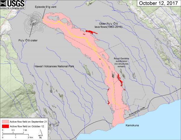
Map of lave flow field. This map shows recent changes to Kīlauea’s East Rift Zone lava flow field. The area of the active flow field as of September 21 is shown in pink, while widening and advancement of the active flow as of October 12 is shown in red. Older Pu‘u ‘Ō‘ō lava flows (1983–2016) are shown in gray. The yellow line is the trace of the active lava tube. USGS/HVO map.
This past week, Kīlauea Volcano’s summit lava lake level fluctuated with summit inflation and deflation, ranging about 105 to 128 feet below the vent rim.
On the East Rift Zone, the 61g flow remained active, with lava entering the ocean near Kamokuna and surface breakouts downslope of Pu‘u ‘Ō‘ō.
The 61g flows do not pose an immediate threat to nearby communities.
Mauna Loa is not erupting. Rates of deformation and seismicity did not change significantly over the past week, but persist above long-term background levels.
GPS measurements continue to show deformation related to inflation of a magma reservoir beneath the summit and upper Southwest Rift Zone.
No significant changes in volcanic gas emissions were measured.
Small-magnitude earthquakes occurred beneath the summit caldera and upper Southwest Rift Zone, primarily at depths less than 3 miles, with some deeper events at depths of 3 to 8 miles.
No earthquakes were reported felt on the Island of Hawaiʻi during the past week.
The Kīlauea Volcano Activity Update is a weekly article written by U.S. Geological Survey Hawaiian Volcano Observatory scientists and affiliates.
Call for summary updates at (808) 967-8862 (Kīlauea) or (808) 967-8866 (Mauna Loa); email questions to [email protected].
FP photo: HVO geologists relocate a time-lapse camera on the rim of the west pit lava pond in the Pu‘u ‘Ō‘ō Crater. Over the past several months, the camera has been slowly tilting downward due to soft, altered ground beneath it, and the general instability of the rim. The new location, about 20 m (yards) to the south, appears to be more stable and less altered. Weak spattering was visible in the west pit lava pond (at the incandescent area near the center of the image) today. USGS/HVO photo.
Sponsored Content


