

OLIVIA WEDNESDAY 9.12.18 FORECAST UPDATES
OLIVIA WEDNESDAY 9.12.18 FORECAST UPDATES: http://mauinow.com/?p=280330
MAUI CLOSURES, CANCELLATIONS: http://mauinow.com/?p
Maui Power Outage Updates: http://mauinow.com/?p
Maui Traffic Advisories, Road Closures: http://mauinow.com/?p
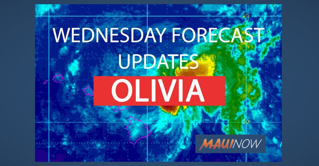
Maui Now graphic. Background image courtesy NOAA/CPHC
*The next full forecast will be released at 5 p.m. The local area forecast will be updated after 5:30 a.m., or as conditions warrant.
UPDATE: 5 p.m. HST 9.12.18
The Tropical Storm Warning has been discontinued for Oʻahu and Maui County including the islands of Maui, Molokaʻi and Lānaʻi as Olivia continues to weaken and move away from the islands.
There are no longer any coastal watches or warnings in effect, however a Flood Warning remained in effect for Maui until 7:15 p.m.
At 5 p.m. HST on Wednesday, Sept. 13, 2018, the center of Tropical Storm Olivia was located 255 miles W of Hilo; 195 miles W of Kailua-Kona; 230 miles WNW of South Point; 200 miles WSW of Hana; 175 miles WSW of Kahului; 145 miles WSW of Kaunakakai; 140 miles WSW of Lanai City; 110 miles SW of Honolulu (near latitude 20.1 North, longitude 159.0 West).
Olivia is moving toward the west-southwest near 20 mph. This motion is expected to continue through tomorrow with a slight decrease in forward speed, followed by a turn toward the west on Friday.
Maximum sustained winds are near 40 mph with higher gusts. Weakening is forecast during the next 48 hours, and Olivia is expected to become a post-tropical remnant low on Thursday night or Friday.
Tropical-storm-force winds extend outward up to 70 miles from the center.
Update: 4:08 p.m., 3:47 p.m., 2 p.m. HST 9.12.18
A Tropical Storm Warning remains in effect for Oʻahu and Maui County.
Active advisories for Maui County at this time include a Tropical Storm Warning, a Flash Flood Warning (until 7:15 p.m on Maui; until 6:15 p.m. on Molokaʻi), and a High Surf Warning for all Northeast and East facing shores until 6 p.m.
A Flash Flood Warning has been extended for the Island of Maui until 7:15 p.m. At 3:59 p.m., radar and rain gages showed that rainfall has diminished across Maui but runoff levels remain high. Maui County Emergency Management reported that the Lower Honoapiʻilani Road has been closed and several homes in the area were evacuated due to flooding. Honolua Gulch also overflowed onto Honoapiʻilani Highway. In east Maui, ʻUlaino Road and Waikoloa Road remain closed near Hāna.
A Flash Flood Warning has been extended for the island of Molokaʻi until 6:15 p.m. on Wednesday, Sept. 12, 2018. At 3 p.m., radar and rain gauges showed that rainfall has eased across Molokaʻi but water levels in Kaunakakai and Kawela Gulches remained high.
Tropical Storm Olivia made brief landfall over Northwest Maui (9:10 a.m. near Kahakuloa) and then over Lānaʻi (at around 9:54 a.m. 6 miles NNE of Lānaʻi City). The system continues on a path W at an increased speed of 20 mph.
At 2 p.m., the center of Tropical Storm Olivia was located 135 miles W of Hāna; 105 miles W of Kahului; 80 miles WSW of Kaunakakai; 75 miles W of Lānaʻi City; 50 miles SSW of Honolulu; 50 miles S of Joint Base PHH; 150 miles SE of Barking Sands; 125 miles SE of Līhue; 155 miles SE of Niʻihau; 795 miles ENE of Johnston Atoll; 1325 miles ESE of Midway (near latitude 20.6 North, longitude 158.1 West).
A turn toward the west-southwest will occur this evening, with a similar west-southwest motion expected through Friday. Maximum sustained winds are near 40 mph with higher gusts. Gradual weakening is forecast during the next 48 hours. Tropical-storm-force winds extend outward up to 90 miles from the center.
UPDATE: 12:20 p.m. HST 9.12.18
The National Weather Service in Honolulu has extended the Flash Flood Warning for the island of Molokai in Maui County until 3:15 p.m. At 11:54 a.m., radar showed that heavy rain has moved over most of Molokaʻi as the center of Tropical Storm Olivia passes to the
south of the island. The gage in Halawa Stream showed a recent increase in water level of 3 feet. Police on Molokaʻi reported that water was flowing across Highway 450 near Kawela.
UPDATE: 11 a.m. HST 9.12.18
Maui is under a Tropical Storm Warning and a Flood Warning as Olivia made historic landfall on the island this morning.
The National Weather Service estimates that the storm made landfall at around 9:10 a.m. near Kahakuloa on the windward coast of the West Maui Mountains, 10 miles NW of Kahului, Maui. Forecasters say the system also made a second landfall on the island of Lānaʻi at around 9:54 a.m.
At 11 a.m. HST 9.12.18, the center of Tropical Storm Olivia was located 70 miles W of Hāna; 40 miles W of Kahului; 15 miles SSW of Kaunakakai; 10 miles NW of Lānaʻi City; 60 miles ESE of Honolulu (near latitude 20.9 North, longitude 157.1 West), which is just west of the island of Lānaʻi.
Olivia is moving toward the west near 15 mph and has maximum sustained winds are near 45 mph with higher gusts.
A turn toward the west-southwest will occur today, with a similar west-southwest motion expected through Friday. Gradual weakening is forecast during the next 48 hours. Tropical-storm-force winds extend outward up to 90 miles from the center.
According to the latest forecast discussion issued by the Central Pacific Hurricane Center, “As strong wind shear persists and Olivia interacts with the high terrain of Molokaʻi and Maui, the system is expected to weaken, which will likely maintain an erratic motion through the afternoon. However, a turn toward the west-southwest is expected as the weaker system becomes increasingly steered by the low-level trade wind flow.”
The Flash Flood Warning for the island of Maui has been extended until 1:30 p.m. At 10:35 a.m., radar indicated heavy rain has moved over the West Maui Mountains with rates estimated at 2 to 3 inches per hour. This rain is expected to spread into the leeward slopes from Lahaina to Kapalua. Heavy rain also continues along the southeastern slope of Haleakalā from ʻUlupalakua to Hāna.
On Molokaʻi, a Flash Flood Warning has been extended until 12:15 p.m. At 856 a.m., radar showed rainfall continuing along the upper slopes of central and east Molokaʻi. Water levels remain high in Kawela and Kaunakakai Gulches. Low water crossings along Highway 450 from Kaunakakai to Pukoʻo likely have flowing water. Rainfall will continue to move over Molokaʻi as the center of Olivia approaches from the East.
The most rain, so far has fallen over the East Maui community. At 10:45 a.m., rain gauges showed new 24 hour totals with 6.74 inches at Puu Kukui; 7.79 at West Wailuaiki; 2.88 at Hāna Airport; 2.03 in Wailuku; 1.10 at Kahakuloa; 2.65 in Pukalani; 1.16 at Waikapū Country Club; 1.27 at Māʻalaea Bay; 2.42 at Mahinahina; and 5.01 at Puʻu Aliʻi on Molokai.
At 7:45 a.m., the USGS rain gauge at West Wailuaiki showed that 7.75 inches of rain had fallen over 24 hours. Over the same period, 4.29 inches had fallen at Puʻu Aliʻi on Molokaʻi. Other locations with significant rainfall amounts include: Hāna Airport (2.53 in); Pukalani (2.42); Mahinahina (2.03); Wailuku (1.81); Māʻalaea Bay (1.19); and Haʻikū (1.07).
This morning, state crews have been dealing with fallen trees and landslides along the Hāna Highway. Power outages were also affecting parts of the Upcountry area, including Makawao, Hāliʻimaile, Olinda, Kula, Haʻikū as well as parts of East Maui.
Overnight, there was a brief power outage affecting an estimated 500 customers in Haʻikū. That was caused by a downed tree on power lines. Also overnight, an estimated 62 people sought shelter across seven evacuation centers in Maui County, with the greatest concentration at Maui High School (30) and the Lahaina Civic Center (16).
LOCAL AREA FORECASTS: (Click here for a drop down menu of your local area forecast)
*The forecast below includes highlights as of 11 a.m. HST from the local area report for specific areas around Maui County: The next local area update is due out at 6 p.m. HST.
WEST MAUI: (Lahaina, Olowalu, Kāʻanapali and Nāpili) Peak Wind Forecast: 35-45 mph with gusts to 60 mph. Window for Tropical Storm force winds: through the next few hours. Peak Rainfall Amounts: Additional 1-3 inches, with locally higher amounts.
WINDWARD WEST MAUI (Including Wailuku) Peak Wind Forecast: 35-45 mph with gusts to 65 mph. Window for Tropical Storm force winds: through the next few hours. Peak Rainfall Amounts: Additional 3-6 inches, with locally higher amounts.
CENTRAL VALLEY: (Kahului, Puʻunēnē and Māʻalaea) Peak Wind Forecast: 20-30 mph with gusts to 40 mph. Peak Rainfall Amounts: Additional 1-3 inches, with locally higher amounts.
WINDWARD HALEAKALA: (Haʻikū, Hāna and Kīpahulu) Peak Wind Forecast: 15-25 mph with gusts to 35 mph. Peak Rainfall Amounts: Additional 4-8 inches, with locally higher amounts.
LEEWARD HALEAKALA (Kīhei and Mākena) Peak Wind Forecast: 15-25 mph with gusts to 35 mph. Peak Rainfall Amounts: Additional 2-4 inches, with locally higher amounts.
HALEAKALA SUMMIT: Peak Wind Forecast: 15-25 mph with gusts to 35 mph. Peak Rainfall Amounts: Additional 2-4 inches, with locally higher amounts.
LANAI MAKAI (Mānele): Peak Wind Forecast: 35-45 mph with gusts to 60 mph. Window for Tropical Storm force winds: through the next few hours. Peak Rainfall Amounts: Additional 1-3 inches, with locally higher amounts.
LANAI MAUKA (Lānaʻi City): Peak Wind Forecast: 30-40 mph with gusts to 60 mph. Window for Tropical Storm force winds: through the next few hours. Peak Rainfall Amounts: Additional 2-4 inches, with locally higher amounts.
MOLOKAI WINDWARD (Kalaupapa): Peak Wind Forecast: 35-45 mph with gusts to 65 mph. Window for Tropical Storm force winds: through the next few hours. Peak Rainfall Amounts: Additional 6-10 inches, with locally higher amounts.
MOLOKAI LEEWARD (Kaunakakai): Peak Wind Forecast: 35-45 mph with gusts to 65 mph. Window for Tropical Storm force winds: through the next few hours. Peak Rainfall Amounts: Additional 3-6 inches, with locally higher amounts.
Tropical Storm – winds 39-73 mph (34-63 kt)
Category 1 – winds 74-95 mph (64-82 kt)
Category 2 – winds 96-110 mph (83-95 kt)
Category 3 – winds 111-129 mph (96-112 kt)
Category 4 – winds 130-156 mph (113-136 kt)
Category 5 – winds 157 mph and up (137+ kt)
____________________________________________
____________________________________________
UPDATE: 10:41 a.m. HST 9.12.18
The Flash Flood Warning for the island of Maui has been extended until 1:30 p.m. At 10:35 a.m., radar indicated heavy rain has moved over the West Maui Mountains with rates estimated at 2 to 3 inches per hour. This rain is expected to spread into the leeward slopes from Lahaina to Kapalua. Heavy rain also continues along the southeastern slope of Haleakalā from ʻUlupalakua to Hāna.
UPDATE: 10:02 a.m. HST 9.12.18
A Flash Flood Warning has been issued for the island of Maui until 1 p.m. At 9:54 a.m., radar showed heavy rainfall over the southeastern slope of Haleakala from ʻUlupalakua to Hāna. Rain rates were estimated to be about 1 to 2 inches per hour. Low water crossings along Piʻilani Highway will become impassable, especially from Waiopae to Kīpahulu and including Pahihi Gulch and Kalepa Gulch.
UPDATE: 7:56 a.m. HST 9.12.18
The Tropical Storm Warning is now limited to Maui County and Oʻahu, as the current path of Olivia takes the system on a direct path over Maui County.
On Molokaʻi, a Flash Flood Warning has been extended until 12:15 p.m. At 856 a.m., radar showed rainfall continuing along the upper slopes of central and east Molokaʻi. Water levels remain high in Kawela and Kaunakakai Gulches. Low water crossings along Highway 450 from Kaunakakai to Pukoʻo likely have flowing water. Rainfall will continue to move over Molokaʻi as the center of Olivia approaches from the East.
The Flood Advisory for the island of Maui has been extended until 9:45 a.m. At around 6:30 a.m., radar showed moderate to heavy rainfall occurring along the windward slopes of Haleakalā and the West Maui Mountains with rates up to one inch per hour. Streams along these windward slopes have been running high. The ongoing rainfall will enhance the risk for landslides, especially along the Hāna and Kahekili Highways.
At 8 a.m. HST on Wednesday, Sept. 12, 2018, the center of Tropical Storm Olivia was located 25 miles NNW of Hāna; 30 miles ENE of Kahului; 60 miles E of Kaunakakai; 60 miles ENE of Lānaʻi City; 120 miles E of Honolulu (near latitude 21.1 North, longitude 156.1 West).
The most rain, so far has fallen over the East Maui community. At 7:45 a.m., the USGS rain gauge at West Wailuaiki showed that 7.75 inches of rain had fallen over 24 hours. Over the same period, 4.29 inches had fallen at Puʻu Aliʻi on Molokaʻi. Other locations with significant rainfall amounts include: Hāna Airport (2.53 in); Pukalani (2.42); Mahinahina (2.03); Wailuku (1.81); Māʻalaea Bay (1.19); and Haʻikū (1.07).
Olivia is moving toward the west near 10 mph. A turn toward the west-southwest is expected today, with an increase in forward speed. This general motion is then expected to continue the next couple of days.
Maximum sustained winds are near 45 mph with higher gusts. Some weakening is forecast during the next 48 hours. Tropical-storm-force winds extend outward up to 90 miles from the center.
This morning, state crews have been dealing with fallen trees and landslides along the Hāna Highway. Power outages were also affecting parts of the Upcountry area, including Makawao, Hāliʻimaile, Olinda, Kula, Haʻikū as well as parts of East Maui.
Overnight, there was a brief power outage affecting an estimated 500 customers in Haʻikū. That was caused by a downed tree on power lines. Also overnight, an estimated 62 people sought shelter across seven evacuation centers in Maui County, with the greatest concentration at Maui High School (30) and the Lahaina Civic Center (16).
LOCAL AREA FORECASTS: (Click here for a drop down menu of your local area forecast)
*The forecast below includes highlights as of 5 a.m. HST from the local area report for specific areas around Maui County: The next local area update is due out at 11:30 a.m. HST.
WEST MAUI: (Lahaina, Olowalu, Kāʻanapali and Nāpili) Peak Wind Forecast: 35-45 mph with gusts to 70 mph. Window for Tropical Storm force winds: until early Thursday morning. Peak Rainfall Amounts: Additional 1-3 inches, with locally higher amounts.
WINDWARD WEST MAUI (Including Wailuku) Peak Wind Forecast: 35-45 mph with gusts to 65 mph. Window for Tropical Storm force winds: until early Thursday morning. Peak Rainfall Amounts: Additional 4-8 inches, with locally higher amounts.
CENTRAL VALLEY: (Kahului, Puʻunēnē and Māʻalaea) Peak Wind Forecast: 35-45 mph with gusts to 70 mph. Window for Tropical Storm force winds: until early Thursday morning. Peak Rainfall Amounts: Additional 1-3 inches, with locally higher amounts.
WINDWARD HALEAKALA: (Haʻikū, Hāna and Kīpahulu) Peak Wind Forecast: 35-45 mph with gusts to 65 mph. Window for Tropical Storm force winds: until early Thursday morning. Peak Rainfall Amounts: Additional 6-10 inches, with locally higher amounts.
LEEWARD HALEAKALA (Kīhei and Mākena) Peak Wind Forecast: 35-45 mph with gusts to 65 mph. Window for Tropical Storm force winds: until early Thursday morning. Peak Rainfall Amounts: Additional 3-6 inches, with locally higher amounts.
HALEAKALA SUMMIT: Peak Wind Forecast: 35-45 mph with gusts to 65 mph. Window for Tropical Storm force winds: until early Thursday morning. Peak Rainfall Amounts: Additional 4-8 inches, with locally higher amounts.
LANAI MAKAI (Mānele): Peak Wind Forecast: 35-45 mph with gusts to 65 mph. Window for Tropical Storm force winds: until early Thursday morning. Peak Rainfall Amounts: Additional 1-3 inches, with locally higher amounts.
LANAI MAUKA (Lānaʻi City): Peak Wind Forecast: 35-45 mph with gusts to 70 mph. Window for Tropical Storm force winds: until early Thursday morning. Peak Rainfall Amounts: Additional 3-6 inches, with locally higher amounts.
MOLOKAI WINDWARD (Kalaupapa): Peak Wind Forecast: 35-45 mph with gusts to 70 mph. Window for Tropical Storm force winds: until early Thursday morning. Peak Rainfall Amounts: Additional 8-12 inches, with locally higher amounts.
MOLOKAI LEEWARD (Kaunakakai): Peak Wind Forecast: 35-45 mph with gusts to 70 mph. Window for Tropical Storm force winds: until early Thursday morning. Peak Rainfall Amounts: Additional 3-6 inches, with locally higher amounts.
Tropical Storm – winds 39-73 mph (34-63 kt)
Category 1 – winds 74-95 mph (64-82 kt)
Category 2 – winds 96-110 mph (83-95 kt)
Category 3 – winds 111-129 mph (96-112 kt)
Category 4 – winds 130-156 mph (113-136 kt)
Category 5 – winds 157 mph and up (137+ kt)
____________________________________________
____________________________________________
PREVIOUS POST:
UPDATE: 6:37 a.m. HST 9.12.18
The Flood Advisory for the island of Maui has been extended until 9:45 a.m. At around 6:30 a.m., radar showed moderate to heavy rainfall occurring along the windward slopes of Haleakalā and the West Maui Mountains with rates up to one inch per hour. Streams along these windward slopes have been running high. The ongoing rainfall will enhance the risk for landslides, especially along the Hāna and Kahekili Highways. Locations in the advisory include but are not limited to: Kahului, Kapalua, Honokōhau, Kahakuloa, Puunene, Hāliʻimaile, Paʻuwela, Waikapu, Lahaina, Pāʻia, Makawao and Wailuku.
UPDATE: 5:58 a.m. HST 9.12.18
The Flash Flood Warning for Molokaʻi has been extended until 9:15 a.m. At 5:46 a.m., stream gauges continue to report very high water levels in Kawela Gulch and Kaunakakai Gulch. Persistent rain has been falling on the higher elevations of Molokaʻi as moisture from Tropical Storm Olivia impacts the island. Maui County emergency management reported very high levels in streams along Highway 450 on the south shore of Molokaʻi. Locations in the warning include but are not limited to: Hoʻolehua, Maunaloa, Kualapuʻu, Kalaupapa National Park, Hālawa Valley, Kepuhi, Kaunakakai, Pukoʻo, Kamalo and Kawela.
UPDATE: 5 A.M. HST 9.12.18
A Tropical Storm Warning has just been dropped for the Big Island. Overnight, Kauaʻi was dropped from the warning. As of right now, Oʻahu and Maui County remained under Tropical Storm Warnings, with the threat of tropical-storm force winds remaining for those communities. That means winds in excess of 39 mph are expected.
The Central Pacific Hurricane Center reported an explosive overnight development of thunderstorms and have called Olivia’s movement over the last 18 hours “erratic” with the storm changing track, intensity and speed. The center of Olivia was just 35 miles offshore to the NNE of Hana in East Maui and 55 miles ENE of Kahului at last report. The current path West near 12 mph takes the system in a direct path over Maui County.
At 5 a.m. HST on Wednesday, Sept. 12, 2018, the center of Tropical Storm Olivia was located 110 miles NNW of Hilo; 105 miles NNE of Kailua-Kona; 160 miles N of South Point; 35 miles NNE of Hana; 55 miles ENE of Kahului; 85 miles E of Kaunakakai; 85 miles ENE of Lanai City; 145 miles E of Honolulu (near latitude 21.2 North, longitude 155.7 West).
Forecasters with the Central Pacific Hurricane Center say Olivia’s current motion is expected to continue through this morning. A motion toward the WSW is expected later today, with an increase in forward speed. Maximum sustained winds are near 45 mph with higher gusts, and some weakening is forecast during the next 48 hours. Tropical-storm-force winds extend outward up to 90 miles from the center.
A Flood Advisory in in place for the island of Maui until 6:45 a.m. There’s also a Flash Flood Warning in effect for Molokaʻi until 6:15 a.m.
At 3:25 a.m., radar and rain gauge data showed persistent moderate rain continuing along the slopes of windward Haleakala and windward west Maui. Rainfall rates up to one inch per hour are occurring, and water levels on Honopou Stream, Honokohau Stream, Hanawi Stream and the Wailuku River remain elevated. Landslides will become increasingly likely as the rain continues, especially on Hana Highway and Kahekili Highway.
At 3:16 a.m. HST, a stream gauge on Kaunakakai Gulch shows a rapid water level rise that will likely overflow the channel and flood Mauna Loa Highway just west of Kaunakakai town. Persistent rain has been falling upslope of this area as moisture from Tropical Storm Olivia impacts the island.
At 2 a.m., radar and satellite imagery showed heavier rain beginning to approach the state. A gust of 47 mph was reported at the Lānaʻi Airport.
Much of Maui is closed for business on today as Maui County stands in the direct path of the approaching storm. Olivia has been described as an “erratic” system, shifting in track, intensity and speed. Heavy thunderstorms have also been popping up on satellite imagery overnight on Olivia’s approach to the islands.
UPDATE 4:49 a.m. HST 9.12.18
A tropical storm warning has just been dropped for the Big Island. Overnight, Kauai was dropped from the warning. As of right now, Oahu and Maui County remained under Tropical Storm Warnings, with the threat of tropical-storm force winds remaining for those communities. That means winds in excess of 39 mph are expected.
At 2 a.m., radar and satellite imagery showed heavier rain beginning to approach the state. A gust of 47 mph was reported at the Lānaʻi Airport.
UPDATE: 3:45 a.m. HST 9.12.18
The National Weather Service has EXTENDED the FLOOD ADVISORY for MAUI ISLAND in effect until 6:45 a.m. There’s also a Flash Flood Warning in effect for Molokai until 6:15 a.m.
At 3:25 a.m., radar and rain gauge data showed persistent moderate rain continuing along the slopes of windward Haleakala and windward west Maui. Rainfall rates up to one inch per hour are occurring, and water levels on Honopou Stream, Honokohau Stream, Hanawi Stream and the Wailuku River remain elevated. Landslides will become increasingly likely as the rain continues, especially on Hana Highway and Kahekili Highway.
At 3:16 a.m. HST, a stream gauge on Kaunakakai Gulch shows a rapid water level rise that will likely overflow the channel and flood Mauna Loa Highway just west of Kaunakakai town. Persistent rain has been falling upslope of this area as moisture from Tropical Storm Olivia impacts the island.
UPDATE: 2 a.m. HST 9.12.18
Olivia continues to creep closer to Maui and was last tracked within 65 miles E of Hāna, Maui and 95 miles East of Kahului at 2 a.m.
The system had slowed yet again to near 7 mph on a path toward the WSW; and maximum sustained winds remained near 45 mph with higher gusts.
At 2 a.m. HST on Wednesday, Sept. 12, 2018, the center of Tropical Storm Olivia was located 75 miles N of Hilo; 100 miles NE of Kailua-Kona; 140 miles NNE of South Point; 65 miles E of Hāna; 95 miles E of Kahului; 130 miles E of Kaunakakai; 125 miles E of Lānaʻi City; and 195 miles ESE of Honolulu (near latitude 20.8 North, longitude 155.0 West).
A general motion toward the WSW, with a gradual increase in forward speed, is expected this morning as the center of Olivia approaches Maui and the Big Island. Forecasters with the Central Pacific Hurricane Center say Olivia will move very close to Maui later this morning. After Olivia moves past the islands, a somewhat faster WSW motion is expected to resume and continue for the next couple of days.
Maximum sustained winds are near 45 mph with higher gusts. Some weakening is forecast during the next 48 hours, but Olivia is expected to remain a tropical storm for the next day or so. Tropical-storm-force winds extend outward up to 90 miles from the center, mainly to the north of the center.
UPDATE: 12:58 a.m. HST 9.12.18
A Flood Advisory is now in effect for the Island of Maui until 3:45 a.m.HST.
At 12:51 a.m. HST, radar and rain gauge data showed persistent moderate rain along the slopes of windward Haleakalā and windward west Maui. Rainfall rates up to one inch per hour are occurring, and water levels on area streams are elevated. Landslides will become increasingly likely as the rain continues, especially on Hāna Highway and Kahekili Highway.
Locations in the advisory include but are not limited to: Kahului, Kapalua, Honokōhau, Kahakuloa, Puʻunēnē, Hāliʻimaile, Paʻuwela, Waikapū, Lahaina, Pāʻia, Makawao and Wailuku.
The public is advised to stay away from streams, drainage ditches and low lying areas prone to
flooding. Rainfall and runoff will also cause hazardous driving conditions due to ponding, reduced visibility and poor braking action. Motorists and pedestrians are reminded not cross fast flowing or rising water in your vehicle, or on foot.
UPDATE: 11 P.M. HST 9.11.18
Kauaʻi was dropped from the Tropical Storm Warning list in the latest forecast update issued at 11 p.m. on Tuesday, Sept. 11, 2018.
Much of Maui is closed for business on Wednesday as Maui County stands to bear the brunt of the incoming storm. Olivia has been described as an “erratic” system, shifting in track, intensity and speed over the past 24 hours. Heavy thunderstorms have also been popping up on satellite imagery this evening on Olivia’s approach to the islands.
At 11 p.m. HST on Tuesday, Sept. 11, 2018, the center of Tropical Storm Olivia was located 80 miles NNE of Hilo; 120 miles NE of Kailua-Kona; 150 miles NNE of South Point; 90 miles E of Hāna; 120 miles E of Kahului; 155 miles E of Kaunakakai; 150 miles E of Lānaʻi City; 220 miles E of Honolulu (near latitude 20.8 North, longitude 154.6 West). Olivia is moving toward the west-southwest near 8 mph.
The Central Pacific Hurricane Center says a general WSW motion and a gradual increase in forward speed is expected overnight as the center of Olivia approaches Maui and the Big Island. After Olivia moves past the islands, a somewhat faster west-southwest motion is expected to resume and continue for the next couple of days.
Maximum sustained winds are near 45 mph with higher gusts with some weakening forecast during the next 48 hour. Despite that, Olivia is expected to remain a tropical storm for the next day or so. Tropical-storm-force winds extend outward up to 90 miles from the center, mainly to the north of the center.
As of 11 p.m., there were a total of 62 people being accommodated at shelters across Maui County with the greatest numbers at Maui High School were 30 people sought shelter and the Lahaina Civic Center were 16 people were spending the night.
LOCAL AREA FORECASTS: (Click here for a drop down menu of your local area forecast)
*The forecast below includes highlights as of 11 p.m. HST from the local area report for specific areas around Maui County: The next local area update is due out at 5:30 a.m. HST.
WEST MAUI: (Lahaina, Olowalu, Kāʻanapali and Nāpili) Peak Wind Forecast: 35-45 mph with gusts to 65 mph. Window for Tropical Storm force winds: until early Thursday morning. Peak Rainfall Amounts: Additional around 1 inch.
WINDWARD WEST MAUI (Including Wailuku) Peak Wind Forecast: 35-45 mph with gusts to 65 mph. Window for Tropical Storm force winds: until early Thursday morning. Peak Rainfall Amounts: Additional 3-6 inches, with locally higher amounts.
CENTRAL VALLEY: (Kahului, Puʻunēnē and Māʻalaea) Peak Wind Forecast: 35-45 mph with gusts to 70 mph. Window for Tropical Storm force winds: until early Thursday morning. Peak Rainfall Amounts: Additional 1-3 inches, with locally higher amounts.
WINDWARD HALEAKALA: (Haʻikū, Hāna and Kīpahulu) Peak Wind Forecast: 35-45 mph with gusts to 65 mph. Window for Tropical Storm force winds: until early Thursday morning. Peak Rainfall Amounts: Additional 6-10 inches, with locally higher amounts.
LEEWARD HALEAKALA (Kīhei and Mākena) Peak Wind Forecast: 35-45 mph with gusts to 65 mph. Window for Tropical Storm force winds: until early Thursday morning. Peak Rainfall Amounts: Additional 2-4 inches, with locally higher amounts.
HALEAKALA SUMMIT: Peak Wind Forecast: 35-45 mph with gusts to 70 mph. Window for Tropical Storm force winds: until early Thursday morning. Peak Rainfall Amounts: Additional 6-10 inches, with locally higher amounts.
LANAI MAKAI (Mānele): Peak Wind Forecast: 35-45 mph with gusts to 65 mph. Window for Tropical Storm force winds: until early Thursday morning. Peak Rainfall Amounts: Additional around 1 inch.
LANAI MAUKA (Lānaʻi City): Peak Wind Forecast: 35-45 mph with gusts to 65 mph.Window for Tropical Storm force winds: until early Thursday morning. Peak Rainfall Amounts: Additional 1-3 inches, with locally higher amounts.
MOLOKAI WINDWARD (Kalaupapa): Peak Wind Forecast: 30-40 mph with gusts to 60 mph. Window for Tropical Storm force winds: until early Thursday morning. Peak Rainfall Amounts: Additional 4-8 inches, with locally higher amounts.
MOLOKAI LEEWARD (Kaunakakai): Peak Wind Forecast: 30-40 mph with gusts to 60 mph. Window for Tropical Storm force winds: until early Thursday morning. Peak Rainfall Amounts: Additional 2-4 inches, with locally higher amounts.
Tropical Storm – winds 39-73 mph (34-63 kt)
Category 1 – winds 74-95 mph (64-82 kt)
Category 2 – winds 96-110 mph (83-95 kt)
Category 3 – winds 111-129 mph (96-112 kt)
Category 4 – winds 130-156 mph (113-136 kt)
Category 5 – winds 157 mph and up (137+ kt)
The following hazard projections were issued by forecasters with the Central Pacific Hurricane Center:
WIND: Tropical storm conditions are expected over portions of Maui County and the Big Island overnight and Wednesday. Tropical storm conditions are expected to begin over Oahu early Wednesday. Remember that wind gusts can be much stronger near higher terrain, and in the upper floors of high-rise buildings. Winds can also be especially gusty through gaps between mountains and where winds blow downslope.
RAINFALL: Showers will continue to increase over portions of the main Hawaiian Islands tonight and Wednesday. Olivia is expected to produce total rainfall accumulations of 5 to 10 inches in some areas, with isolated maximum amounts of 15 inches possible, especially in higher terrain. This rainfall may produce life-threatening flash flooding.
SURF: Large swells generated by Olivia will impact the main Hawaiian Islands over the next couple of days. This will result in dangerously high and potentially damaging surf, mainly along exposed east facing shores.
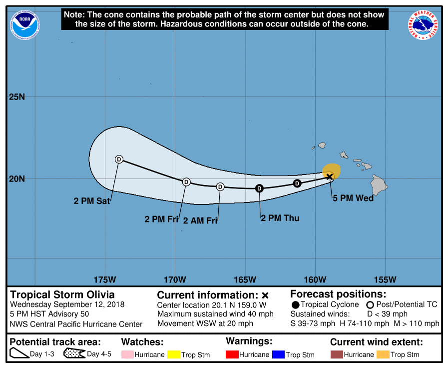
Olivia 5-day cone of uncertainty. PC: (9.12.18, 5 p.m. HST) NOAA/CPHC
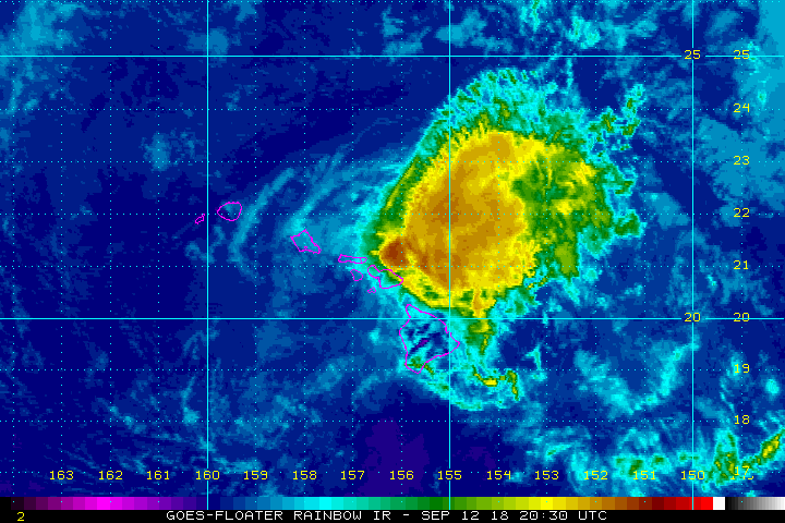
Olivia satellite imagery. PC: (9.12.18, 11 a.m. HST) NOAA/CPHC

Olivia satellite imagery. PC: (9.12.18, 11 a.m. HST) NOAA/CPHC
Olivia satellite imagery. PC: (9.12.18, 11 a.m. HST) NOAA/CPHC
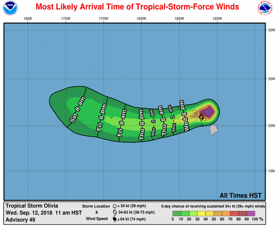
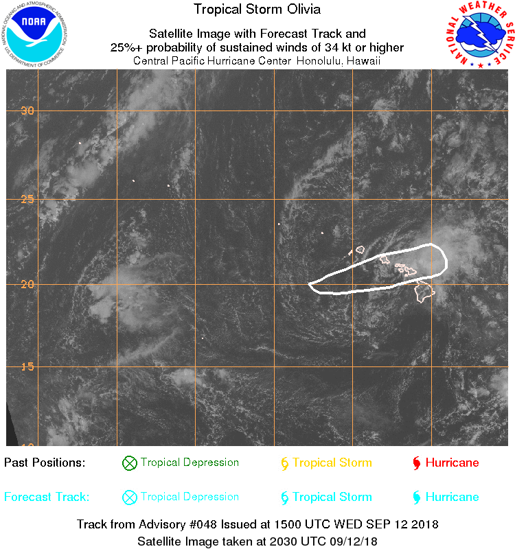
Olivia most likely arrival time of tropical storm force winds. PC: (9.12.18, 11 a.m. HST) NOAA/CPHC
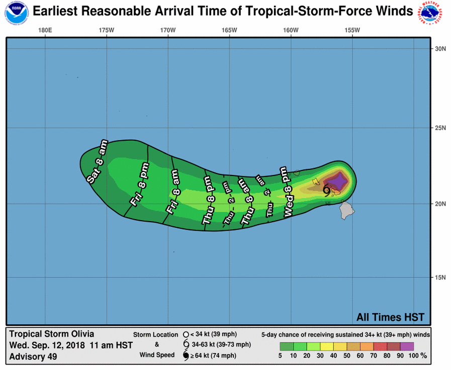
Olivia earliest arrival time of tropical storm force winds. PC: (9.12.18, 11 a.m. HST) NOAA/CPHC
Sponsored Content


