

Why do Some Hawai‘i Quakes Occur so Far Offshore?
Earthquakes in Hawaiʻi are intimately related to the volcanoes. In addition to helping scientists track moving magma, sometimes they happen simply because the earth under the island chain gets bent out of shape.
Earth’s tectonic plates are made of the lithosphere, which is a mostly rigid layer extending from the crust into the upper mantle. As the Hawaiian Islands ride on top of the Pacific Plate, their immense weight bends, or flexes, the lithosphere. Like a bowling ball resting on a soft mattress, this bows the lithosphere downward in a moat-like depression centered on the main loading center under the Island of Hawai‘i. This results in stresses that can lead to earthquakes.
Seismologists call these events “flexural earthquakes” to reflect their cause (plate bending). The massive Island of Hawai‘i produces the largest force on the lithosphere due to its relatively young age, which results in forces on the underlying lithosphere that have not yet evened out.
The zone of maximum bending stress from this load extends about 100 km (62 mi) offshore from the island. As the plate re-adjusts back to a neutral position, it results in a raised bulge in the lithosphere that extends around O‘ahu about 300 km (186 mi) away. This is why earthquakes occasionally happen so far from the main area of seismic and volcanic activity on the Island of Hawai‘i.
There have been two examples of offshore flexural earthquakes in the past month. They include a magnitude-3.7 event on Jan. 21, which occurred about 240 km (149 mi) east of the Island of Hawai‘i, and a magnitude-4.6 event on Feb. 7, about 84 km (52 mi) southwest of the island.
The January event was too small and distant for anyone to feel. But the February earthquake produced shaking intensity up to VI on the Modified Mercalli scale, and was reported by 115 citizens from Hawai‘i, Maui, and O‘ahu, up to 370 km (230 mi) from the epicenter. It was the largest earthquake felt in Hawaiʻi since a magnitude-4.4 earthquake shook theIsland of Hawai‘i on August 9, 2018.
Most earthquakes felt beyond the Island of Hawai‘i are presumed flexural earthquakes based on their estimated locations. Some historical examples include the magnitude-6.8 Lāna‘i earthquake on Feb. 19, 1871; magnitude-6.8 Maui earthquake on Jan. 22, 1938; magnitude-5.2 O‘ahu earthquake on June 28, 1948; magnitude-6.2 Honomū earthquake on April 26, 1973; and magnitude-6.7 Kīholo Bay and 6.1 Māhukona earthquakes on Oct. 15, 2006.
Flexural earthquakes are sometimes called “mantle earthquakes,” reflecting the fact that they often occur at depths within the Earth’s upper mantle rather than within the crust. Seismic waves travel more efficiently through the mantle compared with the crust. This is one reason why mantle earthquakes can have widespread and sometimes damaging effects, especially as their sizes can exceed the magnitude-6 range.
Thankfully, lithospheric flexure produces earthquakes in Hawaiʻi less frequently than those directly related to active volcanism. Each year, the U.S. Geological Survey Hawaiian Volcano Observatory records tens of thousands of earthquakes on and near Hawaiʻi Island’s active volcanoes, compared with only a few hundred offshore flexural events.
The locations and magnitude parameters of earthquakes far offshore are not as well-constrained as events closer to the land-based seismic monitoring network. This is one reason why it’s more difficult for scientists to determine precise locations and depths for earthquakes that happen far from the islands. Nevertheless, any type of earthquake can have hazard implications, so HVO maintains a constant vigil and closely monitors seismic activity in Hawaiʻi.
The next time you feel an earthquake, even if you’re far from it, we encourage you to submit a felt report via the USGS Did You Feel It? website. We also invite you to track earthquakes on HVO’s website.
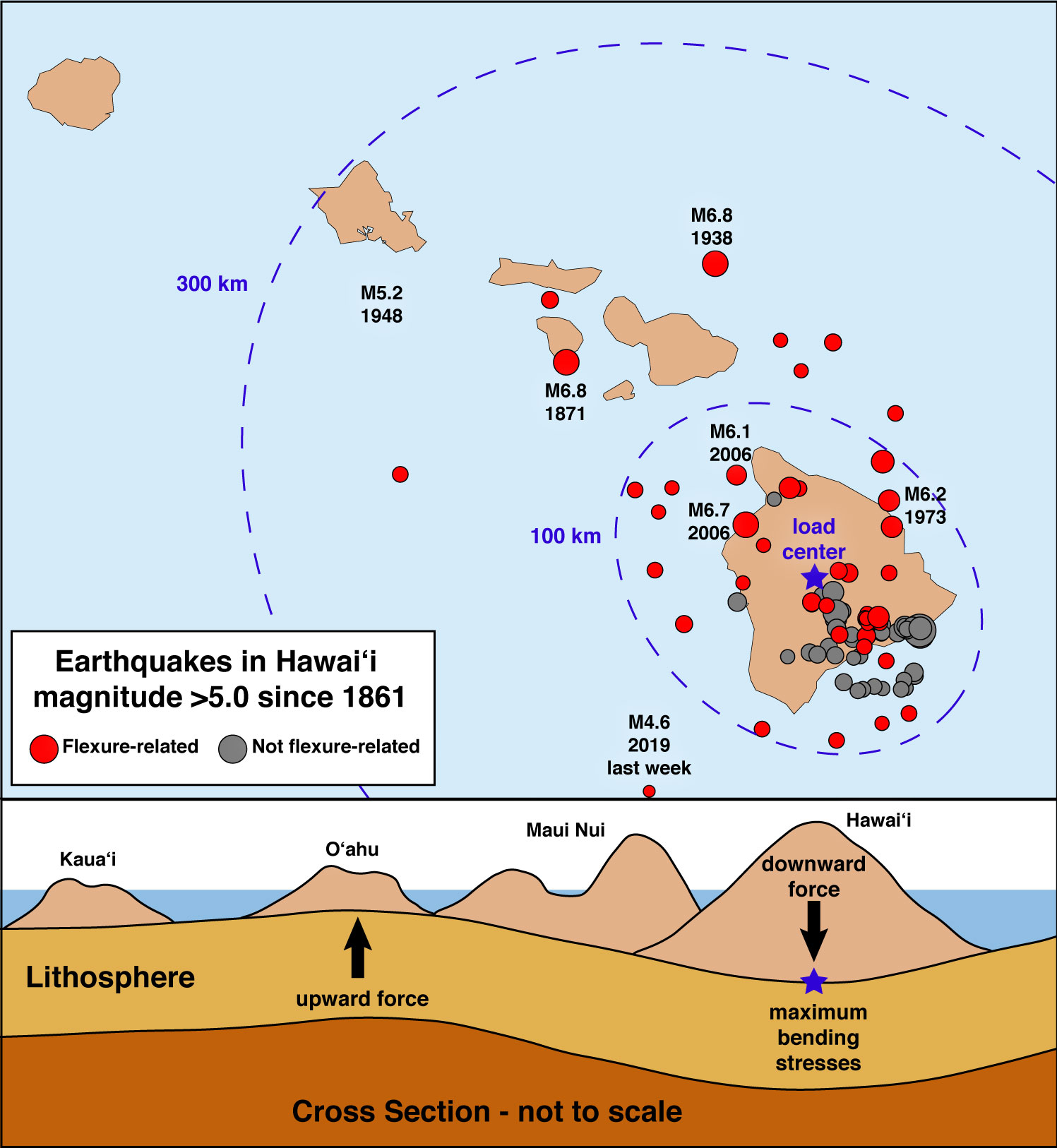
Many of the earthquakes in Hawaiʻi that extend offshore and up the island chain are due to plate bending, or flexure. The upper panel shows magnitude-5 and greater earthquakes since 1861, with some notable events labeled. The area of maximum flexural stress is within about 100 km (62 mi) from where the Island of Hawaiʻi loads the plate, but also extends about 300 km (186 mi) northward, as far as O‘ahu. The lower graphic is a cross-section depicting how the Hawaiian Islands rest on Earth’s lithosphere and cause it to bend. Credit: B. Shiro, USGS HVO.
Volcano Activity Updates
Kīlauea is not erupting. Rates of seismicity, deformation, and gas release have not changed significantly over the past week.
Three earthquakes with three or more felt reports occurred in the Hawaiian Islands during the past week: a magnitude-3.3 quake 13 km (8 mi) east of Honokaʻa at 6 km (4 mi) depth on Feb. 13 at 4:42 p.m. HST; a magnitude-2.1 quake 14 km (9 mi) southwest of Leilani Estates at 3 km (2 mi) depth on Feb. 7 at 9:43 a.m. HST; and a magnitude-4.6 quake 85 km (53 mi) southwest of Hawaiian Ocean View at 27 km (17 mi) depth on Feb. 7 at 9:06 a.m. HST.
Deformation signals are consistent with refilling of Kīlauea Volcano’s deep East Rift Zone (ERZ). Sulfur dioxide emission rates in the lower ERZ have been below detection limits since early September 2018. Sulfur dioxide emission rates at Kīlauea’s summit and middle ERZ remain low, with each generally less than 30 tonnes/day. Occasional sulfur odors detected in some areas of Hawaiʻi Island are explained in a previous Volcano Watch article.
Hazardous conditions still exist at both the lower ERZ and summit of Kīlauea. Residents and visitors in the lower Puna District and Kīlauea summit areas on the Island of Hawaiʻi should stay informed and heed Hawai‘i County Civil Defense closures, warnings, and messages. HVO continues to closely monitor Kīlauea for any sign of increased activity.
The USGS Volcano Alert level for Mauna Loa remains at NORMAL.
*Volcano Watch is a weekly article and activity update written by US Geological Survey Hawaiian Volcano Observatory scientists and affiliates.
Sponsored Content


