

No Tsunami Threat to Hawaiʻi After 7.5 Solomon Islands Quake
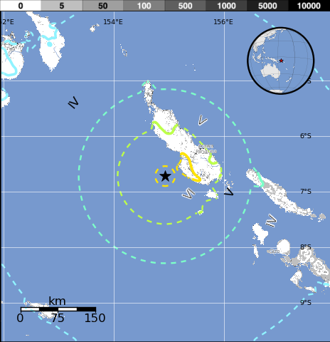
Solomon Islands/Papua New Guinea quake, April 19, 2014. Image courtesy USGS.
By Wendy Osher
(Update: 4:01 a.m. 4/20/14):
Based on all available data, there is no tsunami threat to Hawaiʻi, and no action is required, according to an updated statement from the Pacific Tsunami Warning Center issued at 4:01 a.m. HST, on Saturday, April 19, 2014.
The 7.5 preliminary magnitude earthquake reported at 3:28 a.m. HST on Saturday, April 19, 2014 in the Solomon Islands/Papua New Guinea region.
The quake comes on the heels of a 6.9 earthquake reported at 3:04 p.m. HST yesterday, and less than a week after a 7.6 magnitude quake in the same region reported on Saturday, April 12, 2014. There was also a 7.3 quake reported in the Solomon Islands/Papua New Guinea region on Thursday, April 10, 2014.
(Update 3:40 a.m. 4/19/14):
An evaluation is underway following a 7.5 preliminary magnitude earthquake reported at 3:28 a.m. HST on Saturday, April 19, 2014 in the Solomon Islands/Papua New Guinea region, according to the Pacific Tsunami Warning Center.
The agency says that no action is required at this time; however, a tsunami threat to Hawaiʻi is still being evaluated.
The agency said that based on all available data, there is no destructive tsunami threat to Hawaiʻi; however some coastal areas in the state could experience small non-destructive sea level changes and strong or unusual currents lasting up to several hours.
The estimated time such effects might begin is at 11:56 a.m. HST on Saturday, April 19, 2014, according to the PTWC.
Agency officials said this will be the only statement issued for this event unless additional information is received.
The US Geological Survey reports that the quake occurred at a depth of 19.2 miles and was located: 7 miles SW of Panguna, Papua New Guinea; 54 miles SW of Arawa, Papua New Guinea; 245 miles SE of Kokopo, Papua New Guinea; 339 miles ESE of Kimbe, Papua New Guinea; and 391 miles WNW of Honiara, Solomon Islands.
The quake comes on the heels of a 6.9 earthquake reported at 3:04 p.m. HST yesterday, and less than a week after a 7.6 magnitude quake in the same region reported on Saturday, April 12, 2014. There was also a 7.3 quake reported in the Solomon Islands/Papua New Guinea region on Thursday, April 10, 2014.
Sponsored Content


