

El Niño Upgraded from Moderate to Strong
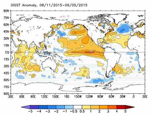
Sea Surface Temperatures – NOAA.
By Wendy Osher
Forecasters with the National Oceanic and Atmospheric Administration say we now have a “strong” El Niño event, upgraded from a “moderate” forecast last month.
During a media teleconference this morning, Mike Halpert, deputy director at NOAA’s Climate Prediction Center said, “There is now a 95% chance that El Niño will last through the winter. Whether it remains strong through the winter, is not at a 95% chance, but we certainly do favor that.”
The latest update forecasts gradual weakening through spring 2016.
In terms of the seasonal rankings for the months of June through August, Halpert says, “2015 is actually ranked third right now, behind 1997, which is not unexpected; and 1987, which probably is unexpected.”
But Halpert described the 1987 El Niño as, “a much different type of event,” saying the ’87 event peaked at this time of year, and was on its way down by this point. “Really, if you look at the ones that peaked in winter, this one is number two,” said Halpert.
Forecasters refrained from making any broader ranking predictions beyond the June to August period saying, “That’s really not something that we forecast, and I suspect we wouldn’t have all that much success in doing it. We’re favoring a strong event. It could potentially be in the top three, but saying any more than that is really just hazarding a guess, and it’s not one that I’m willing to make,” said Halpert.
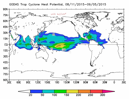
Tropical Cyclone Heat Potential. Image credit: NOAA.
El Niño Impacts in Hawaiʻi Favor Wet Conditions:
In response to our questions about Hawaiʻi impacts, Halpert said, “We’ve seen that El Niño in Hawaiʻi favors wet conditions. I think you’ve actually seen that. Sometimes it has to do with enhanced threat of tropical activity.”
“When you get into the winter though, the signal actually reverses and so it favors drier than average conditions. In the canonical El Niño sense, it also typically favors cooler than average weather–I won’t call it cold since it is Hawaiʻi–but this year we’re still favoring, at least on the Big Island, a warmer than average winter, mainly because the ocean has been so warm around Hawaiʻi that we just don’t expect it to cool significantly by the winter,” he said.
Halpert says El Niño activity certainly plays a role in contributing to an enhanced cyclone season in both the Eastern and Central Pacific.
“We’ve seen that so far, and we would expect it to continue though the typical end of the hurricane season. Whether or not it makes the hurricane season extend longer than it typically does, there’s not any real way to say much about that.”
“El Niño is not a storm; El Niño doesn’t create a storm. It kind of creates the background conditions that become more favorable for, in this case a tropical cyclone, to develop in the Pacific.”
This year’s El Niño conditions developed in March, and continues to strengthen to this point.
In NOAA’s August update, forecasters announced that this El Niño could become among the strongest on record and will likely last into early spring of 2016.
Strong El Niño events are characterized by ocean temperatures in the Pacific Ocean at the Equator at least 1.5 degrees Celsius above normal for three months. Strong El Niños can result in an increase in tropical cyclones in the Pacific.
Sponsored Content


