

Storm Warning Cancelled: Rain Bands Dump 40″ on Hawaii Island
POST STORM ASSESSMENT: http://mauinow.com/?p=278167
Maui Now graphic
UPDATE: 11 A.M. 8.25.18
TROPICAL STORM WARNING CANCELLED
(Courtesy Central Pacific Hurricane Center)
All tropical storms watches and warnings have been discontinued for land areas. That means the Tropical Storm Warnings that were in place for Oʻahu and Maui have since been lifted.
Lane is expected to continue moving to the west and increase in forward speed through tomorrow. This track will keep Lane south of Kauaʻi and Niʻihau tonight.
Flash flooding will continue to be a concern through the weekend. Slow moving rain bands continue to impact the islands primarily from Oʻahu through the Big Island. Lane is expected to produce additional rain of 5 to 10 inches over windward Big Island, and Maui, and 3 to 5 inches elsewhere through the weekend. 20 to 30 inches of rain has already fallen over some parts of windward Big Island, with over 40 inches of rain recorded at a few locations.
A High Surf Advisory remains in effect through today for the south and east facing shores of all islands.
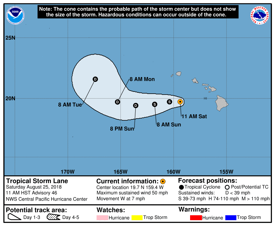
PC: NOAA/CPHC 11 a.m. 8.25.18
At 11 a.m. HST on Saturday, Aug. 25, the center of Tropical Storm Lane was located near latitude 19.7 North, longitude 159.4 West. Lane is moving toward the west near 7 mph and this motion is expected to continue this afternoon through Monday with an increase in forward speed. On the forecast track, Lane is expected to pass about 150 miles south of Kauaʻi later today.
Maximum sustained winds are near 50 mph with higher gusts. Some weakening is forecast during the next 48 hours. Tropical-storm-force winds extend outward up to 100 miles from the center.
___________________________________________________________
PREVIOUS POST: (5 a.m. HST 8.25.18)
A Tropical Storm Warning remains in place for Maui County as the outer rain bands of Lane continue to dump showers over the Hawaiian Islands.
The Central Pacific Hurricane Center reports that the thunderstorms associated with Tropical Storm Lane “are now far removed from the exposed low-level circulation center,” with most of this deep convection affecting the eastern and central Hawaiian Islands in outer rain bands. “Needless to say, severe flooding is occurring due to this, especially over the Big Island where over 40 inches of rain have fallen along parts of the windward sections,” according to the CPHC’s 5 a.m. Forecast Discussion.
The Tropical Storm Warning has since been discontinued for Hawaii County. A Tropical Storm Warning remains in effect for Oahu and Maui County. A Tropical Storm Watch is in effect for Kauai and Niihau
A Tropical Storm Warning means that tropical storm conditions are expected somewhere within the warning area. A Tropical Storm Watch means that tropical storm conditions are possible within the watch area.
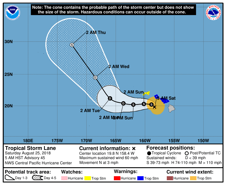
Lane 8.25.18, 5 a.m. 5-day forecast. PC: NOAA/CPHC
SITUATION OVERVIEW
(Courtesy Central Pacific Hurricane Center)
Lane remains a tropical storm early this morning, with maximum
sustained winds of 60 mph. As of 5 a.m. HST on Saturday, Aug. 25, Tropical Storm Lane was located about 110 miles south-southwest of Honolulu and about 165 miles south-southeast of Lihue. Lane is moving slowly to the north at 3 mph.
Lane is expected to continue moving slowly northward this morning, followed by a turn to the west with an increase in forward speed starting later today or tonight. This forecast track takes south of Kauai and Niihau later today and tonight. However, regardless of the storm’s track, life threatening flash flooding and gusty winds will continue to extend far beyond the center’s location. Do not focus on the exact forecast track or intensity of Lane.
Tropical storm conditions are expected in and near outer rain bands across Maui County and Oahu today. Kauai County remains under a Tropical Storm Watch, and tropical storm conditions are possible there starting later today.
Slow moving rain bands associated with Lane continue to affect the island chain from Oahu eastward to the Big Island early this morning. Rains have decreased over Maui County and most of the Big Island during the late night hours, however the potential for additional excessive rainfall remains high, which would lead to life threatening flash flooding, as well as landslides. Flooding will be possible in areas that are typically not prone to flooding. Lane is expected to produce additional rain of 5 to 10 inches in some areas through the weekend. 20 to 30 inches of rain has already fallen over some parts of the windward Big Island, with over 40 inches of rain recorded at a few locations.
A High Surf Advisory remains in effect through today for the south and east facing shores of all islands.
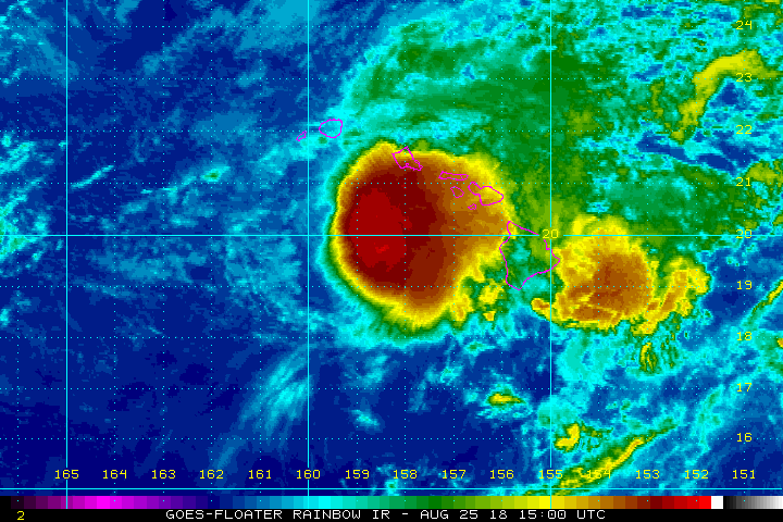
Lane, satellite imagery 8.25.18, 5 a.m. PC: NOAA/CPHC
HAZARDS AFFECTING LAND
(Courtesy: Central Pacific Hurricane Center)
WIND: Tropical storm conditions are still expected in and near outer rain bands that will affect Oahu and Maui County today. Tropical storm conditions are possible on Kauai starting later today.
RAINFALL: Lane’s outer rain bands will produce excessive rainfall this weekend, which could lead to additional flash flooding and landslides. Lane is expected to produce additional rain accumulations of 5 to 10 inches in some areas. Localized storm total amounts well in excess of 40 inches have already been observed along the windward side of the Big Island.
SURF: Large swells generated by Lane will impact the Hawaiian Islands. These swells will produce high surf along exposed south and east shorelines today.
The CPHC notes, “Effects from tropical storms can and do extend well from the center. Rain bands around the northern and eastern periphery of Lane are still bringing persistent flooding rainfall across parts of the state. In addition, damaging winds and isolated tornados are also possible in these rain bands. Winds will be accelerated over higher terrain, through gaps, and where winds blow downslope. Winds will also be stronger at the upper floors of high rise buildings.”
Sponsored Content


