

How is Lava Flow Thickness Measured and Why Does it Matter?
Eruption rate (how much lava comes out of the ground per unit time) is probably the best measure of volcanic activity, and the first step in that calculation is to measure lava flow thickness and area.
During the first few years of Kīlauea Volcano’s Puʻu ʻŌʻō eruption, episodic high lava fountains produced multiple lava flows. After each event, Hawaiian Volcano Observatory scientists measured thicknesses using hand levels at multiple locations along the edges of each lava flow.
The flow volume was then calculated as the product of the flow area multiplied by the average flow thickness. The eruption rate equaled this volume divided by the duration of the eruption in seconds.
For the first year of Puʻu ʻŌʻō activity, calculated eruption rates were 15-65 cubic meters (4,000-17,000 gallons) per second.
But this method didn’t capture all the variations of lava flow thicknesses across flows. For example, many ʻaʻā flows, like Kīlauea’s fissure 8 lava flow in 2018, host an empty lava channel. If we assumed that the flow was uniformly as thick as the height of its edges, we would overestimate the lava flow volume as well as the eruption rate.
It gets better.
In 1993, scientists used an airborne radar flown over Kīlauea at an altitude of just under 8 km (26,000 ft). The radar could image a lava flow with accuracies of 1-2 m (1-2 yds) and determine thousands of surface elevations for each lava flow, not just a few thicknesses along its edge. Flow volumes calculated this way (pre-eruption elevations of the ground surface subtracted from the 1993 elevations of a lava flow) were slightly higher than those calculated with the simpler method of measuring thicknesses along flow edges.
The eruption rates calculated for the continuous lava eruption after 1986 were much lower than for the episodic high fountaining phase—3-5 cubic meters (800-1,300 gallons) per second.
The next improvement in measuring flow thickness was the development and use of Light Detection and Ranging (lidar). Specialized equipment was flown over an area by airplane or helicopter, from which billions of laser pulses showered down to the ground. This produced details on lava flow surface elevations accurate to a few centimeters (an inch or less).
Over the last few years, similar results have been obtained by geologists in helicopters snapping overlapping digital photos of the ground, each tagged with the camera’s GPS coordinates. Computer software, using the “Surface-from-Motion” technique, can automatically identify common locations in adjacent photos and assemble a 3-dimensional image of ground elevations from hundreds of photos. A bonus is that the photos can be stitched together to produce a single, high-resolution, photo mosaic map of the area.
During Kīlauea’s 2018 lower East Rift Zone eruption, cameras on Unmanned Aerial Systems did the photography. Using about 2,800 aerial photographs, the SfM software calculated 1.5 billion common points that were connected to create a centimeter-scale digital elevation model of the Puna lava flow. A pre-eruption lidar digital elevation model was subtracted from the drone SfM digital elevation model of the erupted flows to produce a lava flow thickness map. A preliminary version of this map was posted on the HVO website on Feb. 19, 2019.
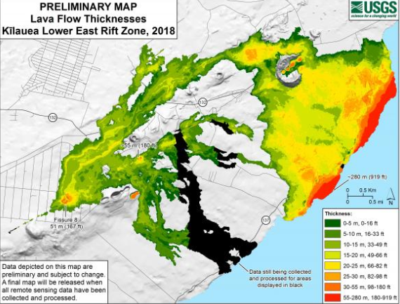
This preliminary thickness map of Kīlauea Volcano’s 2018 lower East Rift Zone lava flows was calculated by subtracting pre-eruption ground surface elevations from post-eruption ground surface elevations mapped with USGS Unmanned Aerial System (drone) flights. The drones acquired 2,800 aerial photos from which 1.5 billion common points were automatically selected by Surface-from-Motion software. It is still preliminary because additional ground control points are needed to finalize the map. PC: USGS.
The posted map is preliminary for two reasons: 1) It is missing coverage of some earlier lava flows to the south, and 2) we need more carefully surveyed ground control points to match the areas unaffected by the 2018 lava flows in the pre- and post-eruption elevation models.
Using the preliminary map, we can calculate a rough estimate of the total volume of lava erupted and added to the land surface—about 0.8 cubic kilometers (over a million cubic yards). When corrected for voids in the lava and divided by the duration of the eruption, this yields a minimum eruption rate of about 50-200 cubic meters (13,000-53,000 gallons) per second. This eruption rate is significantly larger than most, if not all, known Kīlauea eruption rates.
Kīlauea Volcano’s 2018 lower East Rift Zone eruption was a truly remarkable, but very destructive, event that has prompted much discussion and rethinking in various fields, from volcanology to emergency management and land use planning. HVO scientists will be working to better understand the eruption and its significance for years to come.
Volcano Watch is a weekly article and activity update written by US Geological Survey Hawaiian Volcano Observatory scientists and affiliates.
Volcano Activity Updates
Kīlauea is not erupting. Rates of seismicity, deformation, and gas release have not changed significantly over the past week.
Two earthquakes with three or more felt reports occurred in Hawaiʻi during the past week: a magnitude-2.6 quake 11 km (7 mi) southeast of Leilani Estates at 6 km (4 mi) depth on March 3 at 8:50 a.m. HST, and a magnitude-2.7 quake 4 km (2 mi) northeast of Waikoloa at 9 km (6 mi) depth on March 2 at 6:12 p.m. HST.
Deformation signals are consistent with refilling of Kīlauea Volcano’s deep East Rift Zone magma reservoir. Sulfur dioxide emission rates on the ERZ and at Kīlauea’s summit remain low.
Hazards still exist at the lower ERZ and summit of Kīlauea. Residents and visitors near the 2018 fissures, lava flows, and summit collapse area should heed Hawai‘i County Civil Defense and Hawaiʻi Volcanoes National Park closures and warnings. HVO continues to closely monitor Kīlauea for any sign of increased activity.
The USGS Volcano Alert level for Mauna Loa remains at NORMAL.
Sponsored Content


