Recent Collapses at Lava Delta Underscore On-Going Hazard
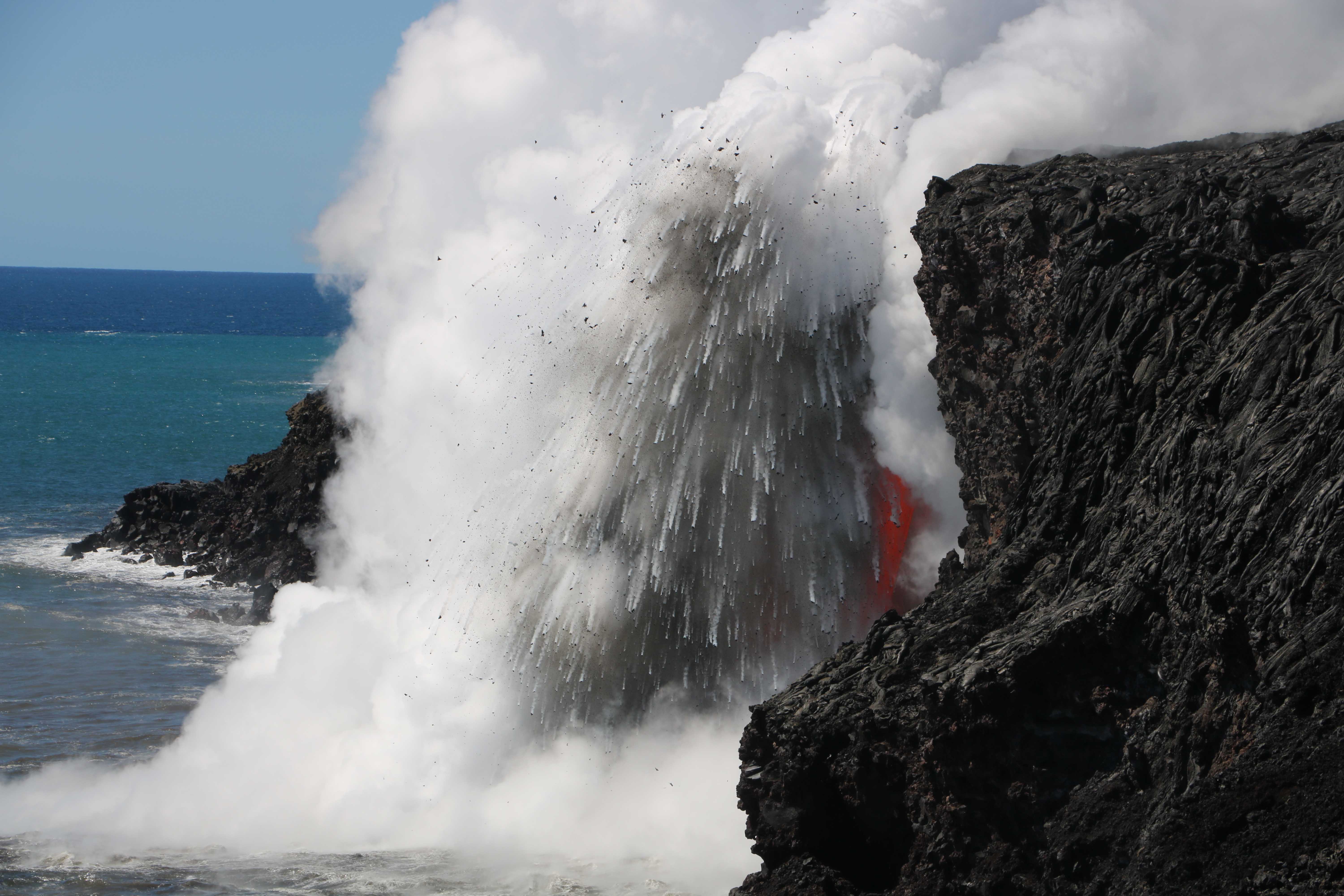
As seen in late January, the interaction of molten lava and cold seawater at the Kamokuna ocean entry produces an explosion, sending hot fragments and steam high into the air. The sea cliff in this image is about 15 meters (50 feet) high. USGS photo.
Since its initiation on July 26, 2016, the Kamokuna ocean entry has drawn thousands of visitors eager to witness the creation of new land.
The interaction of hot lava and cold seawater produces beautiful and powerful displays that can only be observed on Hawai`i Island.
But the ocean entry also represents a unique set of hazards including explosions that send debris and molten spatter into the air, toxic gases in the steam plume, and collapse of the newly created land and adjacent sea cliff. Repeated collapses around the ocean entry since New Year’s Eve of 2016 have underscored the danger of this last hazard.
As soon as the 61g lava flow entered the ocean last summer, it began forming new land, called a lava delta. The lava delta grew seaward, forming a broad, flat shelf. By the end of the year, it had grown to cover an area roughly the size of 18 football fields.
Lava deltas are inherently unstable. They are typically built on top of loose rock fragments that form when the incoming lava hits cold ocean water and shatters. As the lava delta grows, this poor foundation cannot support the added weight, and partial or wholesale collapse sends chunks sliding into the sea.
This was the process at work on Dec. 31, 2016, when almost the entire 23 acre lava delta and 4 acres of the older sea cliff slid into the ocean piece by piece over the course of the afternoon and into the evening.
Small explosions accompanied many of these collapses when newly exposed hot rock came into contact with cold seawater. These sent rocks, steam, and molten lava fragments flying into the air. Large waves were also generated when sections of the lava delta and adjacent sea cliff crashed into the water; some were reported to have splashed as much as 30 feet above the 50-foot cliffs east of the delta.
Since the events of New Year’s Eve, the area has continued to be unstable and large cracks have been observed on top of the cliff behind the ocean entry. In early February, USGS Hawaiian Volcano Observatory staff working in the area noted gentle swaying of the ground – similar to standing in a treehouse on a gusty day – at a distance of up to 650 feet away from the entry.
The exact cause of this ground motion felt so far away is not known, but it was a clear warning of instability. Sure enough, on Feb, 2, 2017, HVO geologists witnessed a large section of the sea cliff behind the ocean entry falling into the ocean.
They had entered the closed area to deploy equipment for monitoring the ocean entry and the gradually widening crack on the sea cliff. Within a minute of HVO geologists reaching the site and just after setting up a camera, the sea cliff seaward of the crack collapsed with no warning. Fortunately, they were far enough away to be unharmed.
The newly placed camera recorded dramatic video of the collapse.
Afterwards, in the video, a remaining section of the surrounding sea cliff sways back and forth for several seconds before coming to a rest. Several hours later, most of this piece of the sea cliff also collapsed.
While the most hazardous sections of the sea cliff are no longer standing as of this writing in early March, the sea cliff near the ocean entry remains unstable and further collapses could occur at any time. Visitors should heed the rope line established by Hawaiʻi Volcanoes National Park at all times and maintain a safe distance when viewing by boat. More information about the hazards associated with ocean entries is available on the USGS Hawaiian Volcano Observatory website.
Volcano Activity Updates
Kīlauea continues to erupt at its summit and East Rift Zone. This past week, the summit lava lake level varied between about 13 and 34 m (43-112 ft) below the vent rim. The 61g flow was still active, with lava entering the ocean near Kamokuna and surface breakouts downslope of Puʻu ʻŌʻō on the pali and the coastal plain. The 61g flows do not pose an immediate threat to nearby communities.
Mauna Loa is not erupting. During the past week, small-magnitude earthquakes continued to occur beneath the volcano, primarily beneath the east flank and upper Southwest Rift Zone. GPS measurements continue to show deformation related to inflation of a magma reservoir beneath the summit and upper Southwest Rift Zone. No significant change in the summit fumarole temperature or gas output was noted this past week.
Five earthquakes were reported felt in Hawaiʻi in the past week. On Sunday, March 5, four earthquakes were felt in the span of 11 minutes between 6:06 and 6:17 a.m. HST. These earthquakes, ranging in magnitude from 3.8 to 3.1 occurred in Kīlauea’s Upper East Rift Zone between 3.6 miles and 2.6 miles southeast of the Kīlauea summit at depths of 1.7 miles to 1.3 miles. On Thursday, March 9 at 3:03 a.m. HST a magnitude 4.2 earthquake occurred 40.2 miles northeast of Kaunakakai, Molokaʻi at a depth of 10.6 miles.
Sponsored Content