

FELICIA 445 MILES ENE OF HILO, WINDS NEAR 50 MPH
(Updated @ 5 p.m. HST Sunday August 9 2009 by Wendy Osher)
TROPICAL STORM FELICIA ADVISORY NUMBERÂ Â 26
Felicia is showing little change in motion and intensity through the afternoon.
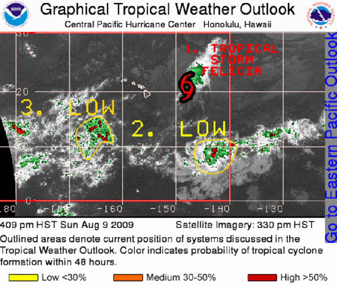
(Click to enlarge image. Satellite graphic created at 4:09 p.m. HST 8/9/09 by NOAA & NWS)
At 5 p.m. Sunday, August 9, 2009, a Tropical storm watch was expanded to include the island of Oahu. A tropical storm watch is now in effect for the Big Island of Hawaii, and for all of Maui County, including the islands of Maui, Kahoolawe, Lanai and Molokai, and for the island of Oahu.
A Tropical Storm Watch means that tropical storm conditions are possible within the watch area, generally within the next 48 hours.
At 5 p.m., the center of Tropical Storm Felicia was located about 445 miles East-Northeast of Hilo, Hawaii and about 610 miles East of Honolulu, Hawaii (near Latitude 21.2 North and Longitude 148.4 West).
Felicia is moving toward the west at 14 mph, and this motion is expected to continue for the next couple of days. The center of Felicia is expected to be near, or over, the Hawaiian Islands by late Monday or early Tuesday.
Air Force reconnaissance data showed maximum sustained winds near 50 mph, with higher gusts. Gradual weakening is forecast for the next couple of days. Felicia could still reach the Hawaiian Islands either as a tropical depression or a tropical storm.
Tropical storm force winds extend outward up to 115 miles from the center. Estimated minimum central pressure was 1002 mb or 29.59 inches.
Even though Felicia is still east of the Hawaiian Islands, a building swell generated by the tropical cyclone has already reached the east facing shores of the Big Island today and will begin to impact the remaining Hawaiian Islands tonight and tomorrow.
Regardless of the strength of Felicia when it reaches the Hawaiian Islands, heavy rains are still expected to occur and flash flooding remains a possibility.
SUMMARY OF 500 PM HST INFORMATION:
LOCATION…21.2N 148.4W
MAXIMUM SUSTAINED WINDS…50 MPH
PRESENT MOVEMENT…WEST OR 280 DEGREES AT 14 MPH
MINIMUM CENTRAL PRESSURE…1002 MB
AN INTERMEDIATE ADVISORY WILL BE ISSUED BY THE CENTRAL PACIFIC HURRICANE CENTER AT 800 PM HST FOLLOWED BY THE NEXT COMPLETE ADVISORY AT 1100 PM HST.
(Updated at 5 p.m. HST Sunday August 9 2009 by Wendy Osher; information provided by FORECASTER KODAMA/KNABB with the NWS & the Central Pacific Hurricane Center)
Sponsored Content


