

AT 5 A.M. 8/10/09: FELICIA 325 MILES E OF HILO, WINDS 45 MPH
(Updated @ 5 a.m. Monday August 10, 2009)
TROPICAL STORM FELICIA ADVISORY NUMBERÂ 28
Felicia weakens slightly as it continues to approach the Hawaiian Islands.
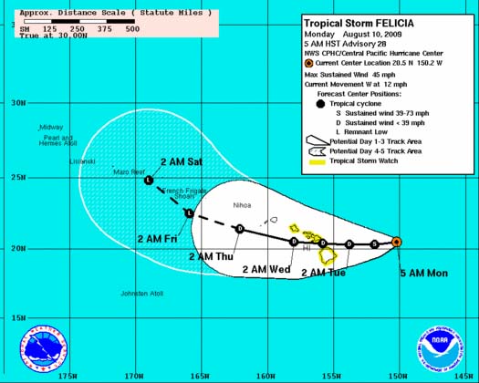
(Click to enlarge image. Cone graphic courtesy NOAA & The National Hurricane Center)
A tropical storm watch remains in effect for Oahu, the Big Island of Hawaii, and for all of Maui County, including the islands of Maui, Kahoolawe, Lanai, and Molokai. A tropical storm watch means that tropical storm conditions are possible within the watch area.
At 500 am HST, the center of tropical storm Felicia was located about 325 miles east of Hilo, Hawaii and about 500 miles east of Honolulu, Hawaii (near latitude 20.5 north…longitude 150.2 west).
Felicia is moving toward the west near 12 mph, and this motion is expected to continue through Tuesday night. On this track…the outer winds from Felicia are expected to reach the easternmost Hawaiian Islands later tonight, before spreading across the central Hawaiian Islands on Tuesday.
Maximum sustained winds are now near 45 mph with higher gusts.
Additional weakening is forecast during the next couple of days.
Felicia is expected to reach the main Hawaiian Islands as either a tropical depression, or possibly a tropical storm if the expected weakening does not occur.
Tropical storm force winds extend outward up to 125 miles from the center.
The latest minimum central pressure reported by the U.S. air force reserves reconnaissance aircraft was 1005 MB, or 29.68 inches.
A large swell generated by Felicia is already affecting the main Hawaiian Islands. This swell will continue to build across the state today and tonight. Also, regardless of the intensity of Felicia when it reaches the Hawaiian Islands, locally heavy rainfall is still expected to occur and flash flooding remains a possibility.
SUMMARY OF 500 AM HST INFORMATION:
Location…20.5n 150.2w
Maximum sustained winds…45 mph
Present movement…west or 260 degrees at 12 mph minimum central pressure…1005 mb
An intermediate advisory will be issued by the central pacific hurricane center at 800 am HST followed by the next complete advisory at 1100 am HST.
(Updated @ 5 a.m. Monday August 10, 2009; information provided by FORECASTER HOUSTON with the NWS, Central Pacific Hurricane Center)
Sponsored Content


