

COUNTY TO DEACTIVATE EOC AT NOON; FELICIA 140 MILES E OF KAHULUI
OVERVIEW 8/11/09 Monday 8 a.m. HST:
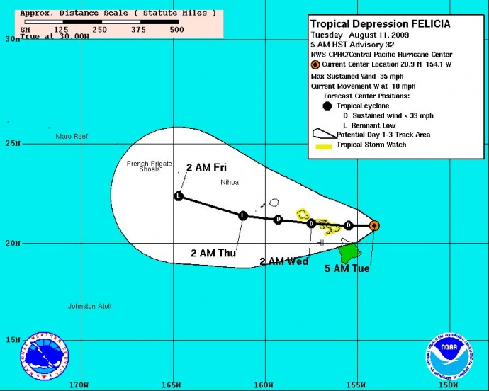
Felicia was downgraded from a Tropical Storm to a Tropical Depression early this morning. The system is now centered just east of the Hawaiian Islands.  With the effects of Felicia diminishing considerably, the County of Maui expects to deactivate its Civil Defense emergency operations at 12 noon today.
(Click to enlarge image. Cone imagery courtesy NWS, NOAA & The National Hurricane Center)
A tropical storm watch remains in effect for Oahu and for all of Maui county, including the islands of Maui, Kahoolawe, Lanai, and Molokai. A tropical storm watch means that tropical storm conditions remain possible within the watch area…in this case within the next 12 to 24 hours.
At 8:00 am HST, the center of tropical depression Felicia was located near latitude 20.8 north…longitude 154.3 west or about 140 miles east of Kahului, Hawaii and about 235 miles east of Honolulu, Hawaii.
The depression is moving toward the west near 10 mph, and this general motion is expected to continue for the next couple of days. The center of Felicia will pass from east to west over the Hawaiian Islands later today and Wednesday. Rain and wind bands began sweeping across the county overnight and the center of the storm is expected to pass near Maui this (Tuesday) afternoon.
Maximum sustained winds are near 35 mph with higher gusts. Felicia is expected to weaken over the next 48 hours.
Estimated minimum central pressure is 1009 mb…29.80 inches.
A large swell generated by Felicia will persist across the state through today and gradually decrease tonight Wednesday. Also, locally heavy rainfall and flash flooding remains a possibility.
Summary of 8:00 am HST information:
Location…20.8n 154.3w
Maximum sustained winds…35 mph
Present movement…west or 270 degrees at 10 mph minimum central pressure…1009 mb
The next advisory will be issued by the central pacific hurricane center at 11:00 am HST.
(Updated @ 8:00 a.m. Tuesday, August 11, 2009 by Wendy Osher; information provided by Forecaster KNABB with the NWS, National Weather Service, Central Pacific Hurricane Center)
Sponsored Content


