

UPDATE: Flossie Maintains Strength, WARNING remains, up to 15 Inches of Rain Possible
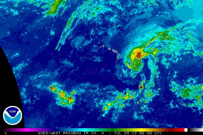
Flossie rb satellite imagery, evening July 28, 2013. Image courtesy NWS, CPHC, NOAA.
By Wendy Osher
(Update: 8 p.m. 7/28/13)
At 8 p.m., on Sunday, July 28, Tropical Storm Flossie was located at about 265 miles E of Hilo, Hawaiʻi; 325 miles E of Kailua-Kona; 310 miles E of South Point
360 miles E SE of Kahului; 415 miles E SE of Kaunakakai; 390 miles E SE of Lanai City; 465 miles E SE of Honolulu; 560 miles E SE of Lihue; and 610 miles E SE of Niʻihau, according to an update from the Central Pacific Hurricane Center.
The system had maximum sustained winds of 60 mph, with movement towards the west at 18 mph.
The system was last tracked at latitude 19.5 N and longitude 151.0 W, according to CPHC reports.
Minimum central pressure remained at 996 mb or 29.41 inches.
A Tropical Storm Warning remains in effect for Maui, Oʻahu, and Hawaiʻi Counties; and a Tropical Storm Watch is in effect for Kauaʻi and Niʻihau.
The National Weather Service says Tropical Storm wind conditions are expected to reach the Big Island of Hawaiʻi by late tonight, Maui County by Monday morning, and Oʻahu by Monday Night.
Heavy rain is expected to begin as early as Monday morning over Hawaiʻi County and Monday afternoon over Maui County, according to the NWS.
NWS forecasters maintain rainfall projections at 6 to 10 inches over Maui and Hawaiʻi Counties, with isolated maximum rainfall amounts of 15 inches possible in isolated windward areas.
Rainfall amounts of 4 to 8 inches are possible over Oʻahu with isolated maximum amounts of 12 inches possible, according to the National Weather Service.
Authorities advise that this rainfall could cause life-threatening flash floods and mud slides, especially in the mountain areas.
The NWS forecast notes that, “dangerously high surf is starting to hammer east facing shores of the Big Island.”
The forecast calls for surf to build overnight, with the largest surf expected Monday into Tuesday.
The NWS notes that the large surf has the potential to cause coastal road closures, even before the storm arrives.
(Update: 2 p.m. Sun., July 28, 2013)
At 2 p.m., Tropical Storm Flossie was last tracked at 370 miles E of Hilo; 465 miles E of Kahului; 520 miles E SE of Kaunakakai; 495 miles E of Lanai City; and 565 miles E SE of Honolulu, according to updated information released by the Central Pacific Hurricane Center.
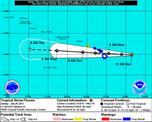
Flossie 5-day track, 11 a.m. Sun., July 28, 2013. NWS officials say model consistency continues, with a slight shift to north in track of the system since the last briefing. Image courtesy NWS/NOAA/CPHC.
The system was last tracked at latitude 19.8 N and longitude 149.3 W, with maximum sustained winds of 60 mph, forecasters with the National Weather Service said. The system continued on a westerly path at last report, traveling at 20 mph.
Minimum central pressure was 996 mb or 29.41 inches.
NWS officials say model consistency continues, with a slight shift to north in track of the system since the last briefing.
(Update: 12 p.m. 7/28/13)
At last report Flossie was located about 430 miles E of Hilo, Hawaii; and 615 miles E of Honolulu. Maximum sustained winds decreased slightly to 60 mph, with the system continuing on a westward path at 20 mph. Minimum central pressure is 996 mb or 29.41 inches.
In addition to Maui and Hawaii Counties, Oahu was also added to the list of areas now under a Tropical Storm Warning.
Maui is expected to sustain the impacts of storm winds (40-45 mph with gusts up to 60 mph) as early as Monday morning, and heavy rains by Monday afternoon. Kauai and Niihau are now under a Tropical Storm Watch.
(Update: 8 a.m. Sun. July 28, 2013)
Forecasters with the National Weather Service say Flossie has maintained its strength as it continues to move toward the Hawaiian Islands. A Tropical Storm Warning remains in effect for Maui and Hawaiʻi Counties; and a Tropical Storm Watch is in effect for Oʻahu. The Warning means tropical storm conditions are expected within 36 hours.
According to the Central Pacific Hurricane Center, the system was last tracked at 8 a.m. at between latitude 19.8 N and longitude 147.5 W and was: 490 miles E of Hilo; 580 miles E of Kahului; 635 miles E of Kaunakakai; 610 miles E of Lanai City; and 680 miles E of Honolulu.
The system was moving west at 20 mph, and had maximum sustained winds near 65 mph. The storm force winds extend outward up to 175 miles from the center, authorities said. Forecasters say a slight slowing if forward speed is projected over the next 48 hours. Minimum central pressure was 996 mb or 29.41 inches.
The first impacts will be in the storm winds which are expected to reach Maui and Hawaiʻi Counties by Monday morning, with possible impacts to O’ahu by Monday night.
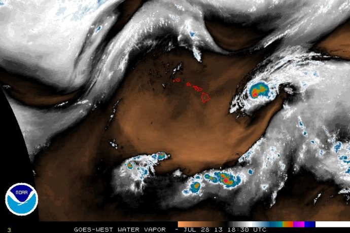
Flossie rb satellite imagery, 8:30 a.m. July 28, 2013. Image courtesy NWS, CPHC, NOAA.
Heavy rainfall is expected as early as Monday morning over Hawaiʻi County and Monday afternoon over Maui County, spreading to Oʻahu by Monday night.
According to NWS forecasters, rainfall of over 6 to 10 inches is expected on Hawaiʻi Island and Maui Counties, and up to 15 inches possible in isolated areas, mainly over the windward slopes. On Oʻahu, forecasters say rainfall is expected to be slightly less with 4 to 8 inches across the island and 12 inches on the windward slopes.
The NWS reminds the public that this kind of rainfall could cause life-threatening flash floods and mudslides, especially in mountain areas.
On the water, surf will begin impacting east-facing shores of all islands as early as tonight, with the largest surf expected on Monday into Tuesday, the NWS said. The agency advises the public to be aware that large surf can cause coastal road closures, even before the storm arrives.
Officials issued an announcement today saying all county facilities will be closed on Monday, July 29, in anticipation of the storm.
Maui Mayor Alan Arakawa also issued a statement as the storm approaches, saying:
“Please stay tuned to this radio station, television news and other media sources of information for the latest developments. In the meantime prepare your emergency kits and secure your home and property against heavy rains and high winds. Make sure you have enough food and water and fuel for several days in case you are unable to leave your home during the storm. The U-S Coast Guard also asks boat owners to check your moorings and secure your vessel.”
Today’s weather is overcast as the storm approaches. The NWS issued a message to explain satellite imagery saying, “Over the state, trade winds are pushing low clouds into windward slopes bringing overcast skies with embedded showers. Higher elevations of the Big Island and Haleakala have clear skies. Leeward locations are mostly sunny this morning with a few patches of cloud cover clinging to the coastline.”
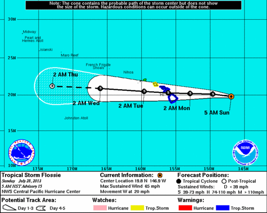
Flossie 5-day Track issued at 5 a.m. 7/28/13. Courtesy NOAA, NWS, CPHC.
Preparedness Tips from the Central Pacific Hurricane Center:
When a hurricane or tropical storm watch is issued some tips that could be useful include:
- Fuel and service family vehicles
- Prepare to cover all windows and door openings with boards, shutters or other shielding materials
- Store and secure outdoor lawn furniture and other loose, lightweight objects, such as garbage cans and garden tools
- Check and replenish disaster supply kits
- Have an extra supply of cash on hand
Watches/Warnings/Advisories Currently in effect include:
- Flash flood watch from Monday morning through late Tuesday night for all Hawaiian islands.
- Tropical storm watch for Oʻahu.
- Tropical storm warning for Molokaʻi, Lānaʻi, Kahoʻolawe, Maui, and Hawaiʻi Island.
- Tropical storm watch for Kauaʻi channel, Oʻahu windward waters, Oʻahu leeward waters.
- Tropical storm warning for Kaiwi Channel (separating Oʻahu from Molokaʻi); Maui county windward and leeward waters; Māʻalaea Bay; Pailolo Channel (between Maui and Molokaʻi); ʻAlenuihāhā Channel (between Hawaiʻi and Maui); Hawaiʻi Island windward, leeward, and southeast waters.
- Small craft advisory until 6 a.m. HST Monday for Māʻalaea Bay; Pailolo Channel; ʻAlenuihāhā Channel; Hawaiʻi Island leeward and southeast waters.
***Supporting information courtesy: National Weather Service, Central Pacific Hurrican Center, and the National Oceanic and Atmospheric Administration.
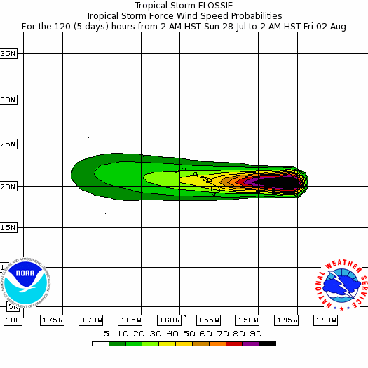
Flossie Wind Speeds issued at 2 a.m. 7/28/13. Courtesy NOAA, NWS, CPHC.
Sponsored Content


