

UPDATE: 2 p.m. 10/16/14 Central Pacific Hurricane Center ANA Briefing
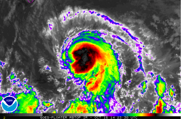
Satellite imagery, 2:15 p.m. HST, Thursday, Oct. 16, 2014, courtesy NOAA/NWS.
By Meteorologist Malika Dudley
***An update as of 5 p.m. on Thursday, Oct. 16, 2014, is now available at the following LINK.
The Central Pacific Hurricane Center conducted a press briefing at 2 p.m. Thursday, Oct. 16, 2014. Warning Coordination Meteorologist Chris Brenchley presented the latest information on Tropical Storm ANA including potential impacts as the system continues to approach the state.
Below are some highlights from the briefing including timing, forecast probability, and anticipated impacts.
Summary of Alerts:
TROPICAL STORM WATCH – Hawaiʻi County / Maui County Leeward Waters & Parts of ʻAlenuihāhā Channel.
FLASH FLOOD WATCH – Entire state / Beginning Friday at noon
HURRICANE WARNING – All Hawaiian Offshore Waters / Starting Friday PM
TROPICAL STORM WARNING – All Hawaiian Offshore Waters / Starting tonight
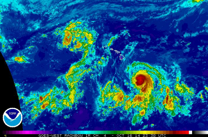
Satellite imagery, 2:15 p.m. HST, Thursday, Oct. 16, 2014, courtesy NOAA/NWS.
Current Situation:
Tropical Storm with 60 mph Maximum Sustained Winds, Gusting to 70 mph
Tropical storm force winds extend 60 miles from the center
Moving W at 8 mph
Tropical Storm Ana was last located near 14.3 N and 150.9 W, about 465 miles SE of Hilo, Hawaiʻi; 505 miles SE of Kailua-Kona, 450 miles SE of South Point, 580 miles SE of Kahului, Maui; 625 miles SE of Kaunakakai, Molokaʻi; 595 miles SE of Lānaʻi City; and 665 miles SE of Honolulu, Oʻahu on Thursday, Oct. 17, 2014 at 11:00am.
A weak high pressure ridge to the north of the state that has been steering the storm is weakening and Ana is expected to turn west-northwest and then northwest. The timing of the northwest turn is integral to the forecast. We’ll keep watching this closely.
ANA is still expected to be a hurricane late Friday. Saturday and Sunday increased wind shear will weaken ANA back down to tropical storm status.
Forecast & Uncertainty:
The current track has not changed much with ANA passing 85 miles southwest of the island of Hawaiʻi Friday night. The timing of possible wind impacts is as follows… Big Island Friday, Maui County Saturday, nearing Oʻahu Saturday night and Kauaʻi on Sunday. Rainfall and cloud cover will occur ahead of the winds.
The probability of tropical storm conditions over Big Island & Maui County leeward and southeast coastal waters is 50 – 60%; 26% in Hilo; 43% in Kailua-Kona and 54% near South Point.
Remember, these systems are notoriously difficult to predict and the center of the storm has a 66% chance of landing anywhere within the cone of uncertainty. The margin of error going out 48 hours is still a whopping 80 miles. Even small shifts in the track can mean major differences in where the worst conditions will occur. Damaging effects can extend far from the center so it’s important that residents prepare just in case.
The Big Island Civil Defense is already reporting surf of 5 to 10 feet at Isaac Hale Park.
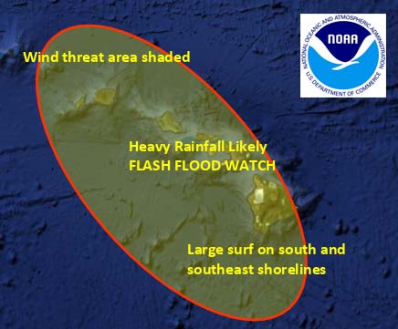
Potential impacts released during Thursday, Oct. 16, 2014 briefing, image courtesy NOAA/NWS.
Potential Impacts (if the track holds):
Heavy rain may reach the Big Island late Friday potentially causing dangerous flash flooding with excessive runoff causing possible mud slides and rock slides. Flooding is possible statewide.
Large dangerous surf conditions are expected to begin impacting the eastern end of the Hawaiian islands spreading westward through the weekend. Additional storm surge of 1 to 2 feet for southeastern shores.
Increasing winds to 30 mph. Gusts could reach 70 mph as the center of ANA passes.
Big Island –
10 to 15 inches with locally up to 20 inches along southeast facing slopes beginning Friday afternoon.
Winds of 25 to 40mph, gusting to 55 mph are possible Friday/Saturday
Seas of 15 to 25 feet. Surf heights up to 20 feet are possible late Friday along the Puna & Kaʻū coastlines during the closest approach. Elevated surf of up to 15 feet is possible along the Kona coasts Saturday.
Maui County –
Seas of up to 15 feet are possible for leeward coastal waters Saturday / Saturday night
Winds of 25 – 45 mph winds are possible starting Saturday afternoon & evening / Strongest winds on southwest side of Maui County, particularly Lānaʻi and Molokaʻi
Locally heavy rainfall, frequent scattered showers, thunderstorms possible Friday – 5 to 10 inches with higher amounts possible.
Tropical Storm conditions possible Saturday / Sunday
Oʻahu –
Tropical Storm conditions possible late Saturday
Locally heavy rainfall, frequent scattered showers, thunderstorms – 5 to 10 inches with higher amounts possible
Winds 30 – 45 mph gradually building Saturday
Kauaʻi –
Effects felt generally about 18 hours after Oʻahu
Possibility of locally heavy rainfall, frequent scattered showers, thunderstorms – 5 to 10 inches with higher amounts possible
Winds 30 – 45 mph gradually building Sunday
Sponsored Content


