

8 a.m. UPDATE: 10/18/14, Tropical Storm Watch Cancelled for Maui
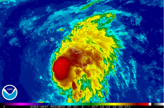
Satellite Image 8 a.m. HST, Saturday, Oct. 18, 2014, courtesy NOAA/NWS.
By Meteorologist Malika Dudley
(Update: 8 a.m., Saturday, Oct. 18, 2014; Update: 5 a.m., Saturday, Oct. 18, 2014)
The National Weather Service cancelled the Tropical Storm Watch that was in effect for Maui County at around 5 a.m. on Saturday, Oct. 18, 2014.
As of 8 a.m., the system was located: 235 miles WSW of Hilo, Hawaiʻi; 170 miles WSW of Kailua-Kona; 185 miles W of South Point; 190 miles SW of Kahului, Maui; 170 miles SSW of Kaunakakai, Molokaʻi; 160 miles SW of Lānaʻi City; 165 miles SSW of Honolulu, Oʻahu; 205 miles SSE of Līhue, Kauaʻi; and 225 miles SSE of Niʻihau.
The agency issued a High Surf Advisory for the south facing shores of Maui saying large swells produced by Ana are expected to impact most of the main Hawaiian Islands today and Sunday.
Although the watch was cancelled, meteorologists advise that bands of heavy rainfall associated with Ana will periodically move over the main Hawaiian Island chain this weekend.
As of 8 a.m., Ana was moving toward the northwest near 13 mph, and had maximum sustained winds near 80 mph.
The Central Pacific Hurricane Center advises that tropical storm conditions are possible over Oʻahu and Kauaʻi county tonight and Sunday.
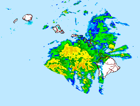
Radar, 8 a.m. HST, Saturday, Oct. 18, 2014, courtesy NOAA/NWS.
(Original Post: 2 a.m. 10/18/14)
Ana has now passed its closest point to the Big Island at this time, and is expected to move to the northwest overnight with little change in forward motion. Ana weakened slightly to 80mph maximum sustained winds. A decrease in forward speed is expected Saturday night and Sunday. The center of Ana is expected to pass within 175 miles southwest of the rest of the main Hawaiian islands this weekend.
Summary of Alerts
FLOOD ADVISORY – Posted for Island of Hawai’i through 4:30 a.m. Posted for the Island of Oahu through 3:45am.
HURRICANE WARNING – In effect for all Hawaiian offshore waters.
TROPICAL STORM WARNING – Still listed for all Hawaiian offshore waters, Big Island leeward coastal waters, and Big Island southeast waters.
TROPICAL STORM WATCH – No longer in effect for Maui County. Still posted for Oahu and Kauai **As of 5am update**
HIGH SURF WARNING – West shores of Big Island through 6:00pm.
HIGH SURF ADVISORY – South shores of Big Island until 6:00pm.
SMALL CRAFT ADVISORY – Big Island windward waters through 6:00pm.
Current Situation
At 2:00am on Saturday October 18, 2014 the center of Hurricane Ana was located 220 miles SSW of Kahului, 215 miles SSW of Kaunakakai and 200 miles SSW of Lanai City. Ana is still a Category 1 hurricane with 80 mph maximum sustained winds. The system is moving northwest at 13 mph. Hurricane force winds extend outward 25 miles from the center, and tropical storm force winds extend 115 miles.
A decrease in forward speed is expected later today and Sunday, with a turn toward the west. On the forecast track, the center of Ana will pass about 175 miles southwest of the rest of the main Hawaiian islands this weekend. Ana is expected to maintain hurricane status through Saturday and slowly weaken Sunday.
As the strongest winds associated with Ana move away from the Big Island, the tropical storm watch has been cancelled for the Big Island and windward Big Island waters. While tropical storm conditions are not expected to occur in these mentioned areas, surf and seas generated from the storm continue to be elevated.
Outer rain bands of hurricane Ana continue to bring showers and thunderstorms to the Big Island. Rainfall has been slowly increasing across Maui county and Oahu, and should expect this trend towards increasing winds and showers over the smaller islands.
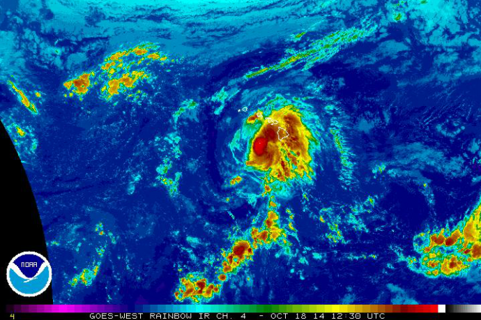
Satellite Image 2 a.m. HST, Saturday, Oct. 18, 2014, courtesy NOAA/NWS.
Potential Impacts to Maui County
Strong gusty winds are possible in any heavier showers or thunderstorms overnight, Saturday, and Saturday night.
Chance of tropical storm conditions is 67% or lower for windward waters, 25% or lower for leeward waters, 6% for Kahului, 8% for Lanai and at 8% for Kaunakakai.
Timing: We expect to start seeing some effects, mainly surf and rain through Saturday morning. Conditions will gradually deteriorate. Tropical storm conditions are possible Saturday into Sunday. Maui County could be under the effects of ANA for about 24 hours.
Wind: For Haleakala wind predictions are at 35 – 45 mph, gusting to 60 mph. Lower elevations of all islands are not expected to get winds above 39 mph at this time however there is still a small chance that could occur. Winds of 20 – 30 mph winds, gusting to 35 mph are possible Saturday afternoon & evening with the strongest winds on the southwest side of Maui County, particularly Lanai and Molokai.
Rain: Rainfall of 2 to 8 inches is possible across Maui County. Higher amounts are expected for mountainous terrain and along slopes where there is lift.
Surf: Ana will produce warning level surf of 10-15 ft along south facing shores Saturday and remain elevated through Sunday.
Seas: Ana is expected to produce winds at 30 – 40 mph and seas up to 20 ft across leeward coastal waters Saturday through Sunday. An incoming northwest swell combined with strengthening winds will produce hazardous seas across the remainder of the coastal waters Saturday night and Sunday.
***Maui Now News Director Wendy Osher contributed to this report.
Sponsored Content


