

5 p.m. Tropical System Update: Guillermo and Hilda

Image: CPHC 5 p.m. Guillermo track
By Meteorologist Malika Dudley / Email: [email protected]
(Update: 5 p.m. 8/6/15)
Guillermo is now a tropical depression as of the 5:00 p.m. Central Pacific Hurricane Center update.
As a result, all Tropical Storm Watches and Warnings have been dropped. The High Surf Warning has been extended through 6:00 a.m. Friday morning. A less urgent Small Craft Advisory replaces the tropical storm alerts that were posted for coastal waters.
The system has maximum sustained winds of 35 mph and is moving west at 9 mph. A gradual turn to the west-northwest is expected tonight with this forward movement continuing through dissipation of the system expected on Saturday.
Guillermo is currently located 65 miles NE of Kahului, 100 miles ENE of Kaunakakai and 95 miles NE of Lanai City. The system is forecasted to pass 60 miles north of Maui tonight and within 30 miles north of Oahu and Kauai late tonight and Friday.
Guillermo will bring scattered showers over the state mostly to the windward slopes. East southeast winds will build behind the system on Friday, and shift to trade winds Saturday into early next week.
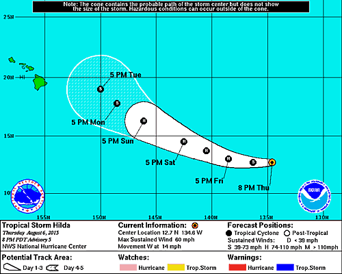
Image: NHC 5 p.m. track Hilda
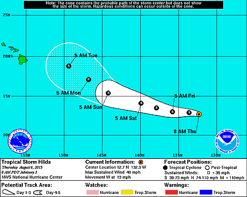
Hilda is holding steady with maximum sustained winds of 60 mph as of the 5 p.m National Hurricane Center update.
The storm, located 1540 miles ESE of Kahului, 1600 miles ESE of Kaunakakai and 1575 miles ESE of Lanai City, continues to move W at 14 mph. This motion should continue through early tomorrow before the system veers west-northwest late Friday evening and slows down.
Hilda is still quite compact and small however tropical storm force winds extend twice as far as they did on the last update, now 60 miles from the center.
The system is expected to be over warm seas without significant vertical wind shear. This is expected to lead to strengthening with Hilda becoming a hurricane in the next 24 hours.
TS Hilda / Image: NHC 2 p.m. August 6, 2015
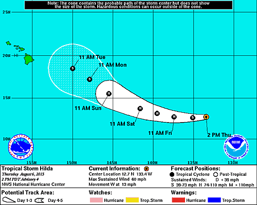
(Update: 2 p.m. 8/6/15)
Hilda is holding steady with maximum sustained winds of 60 mph with higher gusts. The storm, located less than 1500 miles ESE of Hilo rapidly increased in strength and organization over the last 12 hours as it continues to move W at 13 mph. This motion should continue through early tomorrow before the system veers west-northwest late Friday evening.
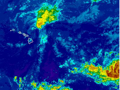
NWS Satellite Guillermo and Hilda / August 6, 2015
Hilda is quite compact and small especially compared to our last system, Guillermo. Tropical storm force winds extend just 35 miles from the center.
The track has been shifted left compared to the previous forecast track. In the short term, Hilda is expected to gain strength becoming a hurricane by Friday. Two to three days from now Hilda is expected to begin a weakening trend as it encounters unfavorable conditions for further development.
(Update: 11 a.m. 8/6/15)
The Central Pacific Hurricane center is forecasting Guillermo or its remnant center to pass about 60 miles north of Maui late today, 20 miles north of Oʻahu tonight, and near Kauaʻi on Friday morning.
At 11 a.m., the center of the Guillermo was located 140 miles N of Hilo and 90 miles NE of Kahului, Maui.

Guillermo and Hilda wind probabilities – Image: NHC 2 p.m. August 6, 2015
Maximum sustained winds remain near 40 mph with tropical storm force winds extending outward up to 115 miles from the center.
The CPHC forecast continues to advise the public of large, life-threatening surf along the east facing shores today.
Waiʻānapanapa State Park on Maui remains still closed today due to dangerous surf conditions and is expected to reopen tomorrow.
Meantime in the East Pacific, Tropical Storm Hilda strengthened and now has maximum sustained winds at around 60 mph. The system is forecast to become a hurricane by Friday. It’s current movement is to the west near 13 mph.
***Pacific Media Group News Director Wendy Osher contributed to this report.
—-
(Update: 5 a.m. 8/6/15)
Guillermo is rapidly weakening and should become a tropical depression some time later today.
As of the Central Pacific Hurricane Center’s 5 a.m. Guillermo update, the center was located 140 miles ENE of Kahului, 185 miles ENE of Kaunakakai and 175 miles ENE of Lanai City. Guillermo is currently classified as weak tropical storm with maximum sustained winds at 40 mph. The system is moving west at 12 mph and tropical storm force winds extend 150 miles from the center mainly in the northeastern quadrant.
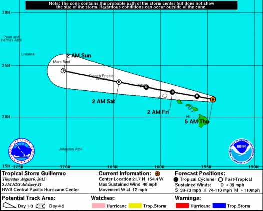
Image: CPHC 5 a.m. August 6, 2015
The current track has been nudged south and is left of the previous forecast track (closer to the islands). As a result, a Tropical Storm Warning has been issued for windward waters in Maui County. However, the primary threat remains on the northeastern side and given the current rapid rate of decay, Guillermo is expected to weaken to a depression by later this morning or afternoon.
CURRENT ALERTS:
A Tropical Storm Warning is now in effect for the windward waters of Maui County. If you live on a boat, safely secure your craft and make plans to seek shelter on shore. This warning replaces the watch that was previously posted for this area.
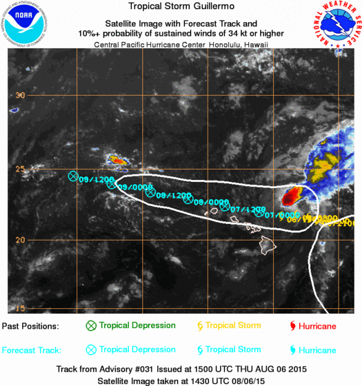
Image: CPHC 5 a.m. August 6, 2015
A High Surf Warning has been issued through 6:00 p.m. Thursday for east-facing shores of Maui and Moloka’i. Wave heights of 10 to 15 foot faces are expected today and tonight. Expect ocean water occasionally sweeping across portions of beaches. Very strong breaking waves and strong longshore rip currents. Breaking waves may occasionally impact harbors making navigating the harbor channel dangerous.
A Tropical Storm Warning is also in effect for offshore waters beyond 40 nm and out to 240 nm.
We are also now tracking a tropical storm in the Eastern Pacific. Overnight Hilda strengthened from a tropical depression to a weak tropical storm with maximum sustained winds currently at 40 mph. According to the National Hurricane Center, the system is forecasted to become a hurricane Saturday or Sunday.
TS Hilda / Image: NHC 5 a.m. August 6, 2015
Hilda is currently moving west near 13 mph. Tropical storm force winds extend 35 miles from the center. The track currently has the system eventually moving northwest and toward the Hawaiian Islands.
Sponsored Content


