8:00 p.m. UPDATE: Hilda Slows Down to a Crawl
Weather forecast by NWS for 4 p.m. tomorrow afternoon
By Meteorologist Malika Dudley / Email: [email protected]
(Updated at 8:00 p.m.)
Tropical Storm Hilda has maintained its strength with 65 mph maximum sustained winds. However, the system has slowed down to a crawl and is moving just 1 mph in a westerly direction.
With the broad moisture field associated with Hilda, the slower it passes by the state, the more moisture we could potentially get. Hilda is expected to speed up some tonight and continue the next couple of days. But the system is still expected to be moving rather slowly.
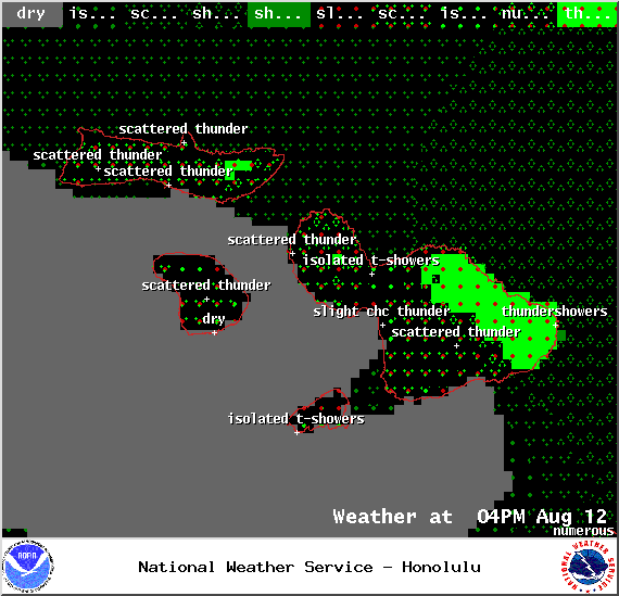
The rainfall and other forecasts remain the same and all weather alerts remain posted at this time. The image above shows the National Weather Service’s forecast for tomorrow afternoon.
(Updated at 5:00 p.m.)
As of the 5:00 p.m. Central Pacific Hurricane Center update, Hilda has maximum sustained winds near 65 mph and continues its weakening trend.
Our strong westerly winds are really taking their toll on Hilda and tearing the system apart. Hilda should weaken to a tropical depression Wednesday night or Thursday and become a remnant low by Friday afternoon.
The system, located 360 miles SE of Hana, 385 miles SE of Kahului, 420 miles SE of Kaunakakai and 405 miles SE of Lanai City, is moving west near 5 mph and this general motion is expected to continue over the next couple of days.
Gentle to moderate trade winds are expected to continue as tropical storm Hilda slowly nears the Big Island over the next 24 to 30 hours. An upper low remains north of the state and will enhance some of the low level moisture over the area producing some localized heavy rain and a slight chance of thunderstorms Wednesday. Hilda is expected to bring widespread rain across the Big Island, with some rain expected for the smaller islands.
The forecast for Maui County still calls for mostly cloudy skies, scattered showers and the chance of heavy rain and thunderstorms on Thursday and Friday.
(Updated at 2:00 p.m.)
Hilda has weakened to a tropical storm. Maximum sustained winds are now at 70 mph, making it a strong tropical storm at this time. The system is moving W at 6 mph and tropical storm force winds now extend 85 miles from the center.
All forecast guidance remains unchanged and all weather alerts listed below are still in effect. The Hurricane Warning is now a Tropical Storm Warning.
Heavy rain, thunderstorms and possible flooding conditions are still possible along Hilda’s track and to the north of it. We will keep an eye on Hilda and bring you the latest.
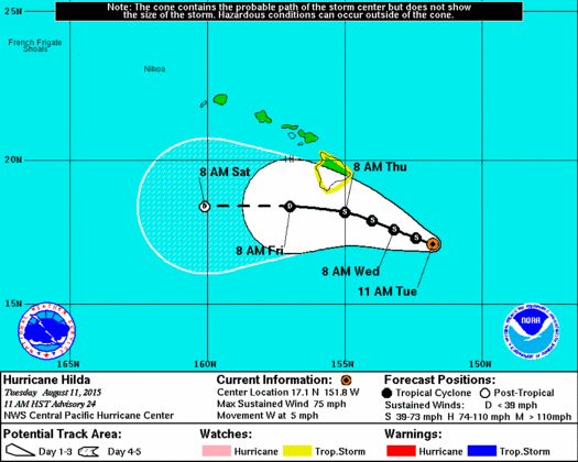
11 am CPHC Hilda track
(Updated at 11:00 a.m.)
The latest report from the CPHC shows Hilda moving south of the islands. Hilda remains a low-grade hurricane with 75 mph winds. The weakening trend is expected to continue and with a shallower, weaker system trades will likely steer it onto the current forecast track.
The system is currently 375 miles SE of Hana, 400 miles SE of Kahului, 435 miles SE of Kaunakakai
and 420 miles SE of Lanai City. It is moving west at 5 mph.
All weather alerts remain in place however due to the unpredictable nature of these systems. Heavy rain is still possible for Maui later this week. Will keep an eye on it and bring you the latest.
For the Big Island, the cumulative chance for tropical storm conditions at this time ranges from 8 to 22 percent. This represents a general downward trend since the last forecast. Rainfall chances remain elevated with 6 – 12 inches still possible. Up to 18 inches are possible in mountainous terrain.
Although changes are still possible, the latest forecast is for sustained winds on the Big Island to remain below tropical storm force of 39 mph. Strongest winds will accompany Hilda’s closest approach to the Big Island from Wednesday night through Thursday night. There is the possibility of minor wind damage.
[flashvideo file=http://www.youtube.com/watch?v=WMY3x3nd2y0 /]
(Updated at 9:30 a.m.)
A Flash Flood Watch has been issued for the Big Island. This watch goes into effect at 6:00 p.m. on Wednesday through 6:00 a.m. Saturday. Abundant moisture from weakening Hilda is expected to produce the potential for excessive runoff, rock/mudslides and fast-moving water that could create life-threatening situations.
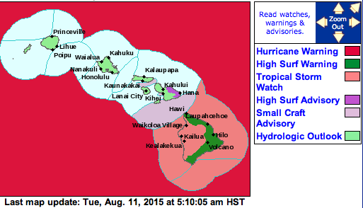
NWS 5 a.m. Hilda alerts
The National Weather Service has released it’s current rainfall projections for the Big Island. Total rainfall projections are currently between 6 to 12 inches with possible maximum totals up to a foot and a half. Very heavy rain is expected to arrive Thursday and continue into Friday. This type of rain can cause flash flooding and mudslides.
If the latest track and intensity remains true, the forecast calls for a 16 to 29 percent chance of tropical storm conditions. Portions of the island could also see tropical storm force winds of 39 mph or more from Thursday morning to Thursday afternoon.
The possibility of this moisture extending to Maui remains. Especially when you take into account the uncertainty of the track and the fact that on the current track we are exposed to the wetter, northeast side of the system.
For now, the forecast for Maui County calls for mostly cloudy skies and scattered windward showers Thursday and Friday with the possibility of heavy rain. There is also a slight chance of thunderstorms. This is highly dependent on the eventual track and intensity of Hilda so we will update the forecast as we learn more.
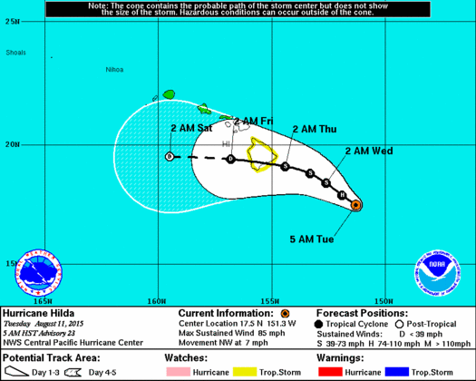
CPHC 5 a.m. Hilda track
(Updated at 8:00 a.m.)
Forecast guidance remains unchanged. Maximum sustained winds are now near 75 mph, making Hilda a weak Category 1 hurricane. Slow weakening is expected to continue today.
Hilda is now 385 miles SE of Hana, 415 miles SE of Kahului, 455 miles SE of Kaunakakai and 435 miles SE of Lanai City. The exact location of Hilda’s center is hard to determine but Hurricane Hunters will be flying into the system later today and will give us a better idea.
(Updated at 5:00 a.m.)
As of the 5:00 a.m. Central Pacific Hurricane Center update, Hilda has maximum sustained winds at 85 mph and remains a Category 1 hurricane. The system is weakening and expected to become a tropical storm by tonight as winds dip below 75 mph. A slew of new weather alerts have been posted by the National Weather Service. See the link at the bottom of this post for your daily weather report and a list of those alerts.
NWS Meteorologist, Bob Ballard, in a social media post Monday night stated, “Very concerned about the 5 day total rainfall amounts the guidance is showing for the Big Island from Hilda. If they’re right, it could be BIG problems. It’s not a guarantee yet, but Big Islanders, you should seriously be getting ready for the possibility of major rains later this week. We could be measuring the rainfall in feet rather than inches.”
On satellite Hilda looks a little more ragged and you can actually see how strong westerly winds are beginning to slowly shred it apart.
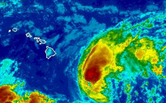
NWS 5 a.m. Hilda satellite
Models are having a hard time with regard to Hilda’s track and intensity largely driven by a disagreement between the models on the amount of convection (the strength) Hilda will still have as it continues to approach. Uncertainty on that front has led to the issuance of a Tropical Storm Watch for the Big Island (details at link below). The strength of the system is also a driving factor for the systems track. If the system goes against current guidance and retains its strength it will be steered north of the current track and if it continues to weaken it is expected to veer westward.
The storm, located 380 miles SE of Hana, 410 miles SE of Kahului, 455 miles SE of Kaunakakai and 435 miles ESE of Lanai City, is moving NW near 7 mph and this general motion is expected to continue into Thursday.
Hurricane force winds extend 25 miles from the center and tropical storm force winds extend up to 70 miles from the center.
Although Hilda is a compact tropical cyclone, the low level moisture field surrounding the system is pretty broad. This means islands to the east of the track could see an increase in shower activity even if Hilda is several hundred miles away. In fact, we could start to see moisture on the edge of the system begin to affect the Big Island as early as Tuesday. The latest Hydrologic Outlook released by the National Weather Service warns of heavy rain, thunderstorms and flooding conditions possible as early as Wednesday night.
The National Weather Service also warns that regardless of the system’s strength, the potential for very heavy rainfall exists for the entire state. Details on timing, location and amount of rainfall are highly dependent on the eventual track Hilda takes. If the system continues on its current track, the entire state will be exposed to the wetter northeast side of the system (as compared with Guillermo which went north and exposed the islands to the less wet southern side of the storm).
***Click here for your ocean and surf condition report for today.***
Sponsored Content