

5 p.m. UPDATE: Kilo Track Shifts Away From Islands
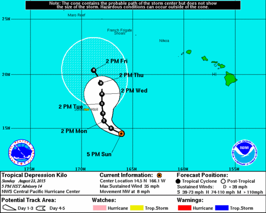
5 pm CPHC Kilo track
(Updated at 5 p.m.)
By Meteorologist Malika Dudley
As of the 5 p.m. CPHC update, Kilo has held maximum sustained winds near 35 mph with higher gusts. Gradual strengthening is expected with Kilo becoming a tropical storm Monday.
The system is moving west-northwest at 8 mph and expected to move northwest Monday and eventually north Monday night and Tuesday. The latest track reflects this and has been nudged even farther to the left of the previous track.
 WEATHER FORECAST
Although tropical cyclone Kilo is centered well SW of the islands, southerly flow to the E of the system has dragged a very moist and unstable air mass over the islands and surrounding waters. Heavy showers and thunderstorms are popping up because of this. It’s also extremely muggy outside so sweat does not evaporate as quickly, preventing the body from releasing heat quickly. If participating in strenuous outdoor activities the the next couple of days, the National Weather Service advises you “to be sure to drink plenty of non-alcoholic fluids.” Also if venturing outdoors, be aware of the dangers posed by cloud to surface lightning strikes, and remember that lightning can strike even if it is not raining at your location.
Heavy showers and thunderstorms will remain possible through about mid-week. Although the official forecast from the Central Pacific Hurricane Center brings Kilo closer to the W end of the chain late in the week, for now it is not expected to lead to increased winds over the area. Moisture over the area is expected to diminish somewhat around Thursday and Friday. Light trade winds should begin filling in for the second half of the work week.
(Updated at 11 a.m.)
By Meteorologist Malika Dudley
As of the 11 a.m. CPHC update, Kilo has held maximum sustained winds near 35 mph with higher gusts. Most forecast guidance listed in the 5 am update holds true.
Kilo is looking a little more organized on satellite. The latest track has been nudged even farther to the left of the previous track (see 5 am track).
A Tropical Storm Watch has been issued for Johnston Atoll since the system is now forecast to pass closely to the east of there Monday night and Tuesday.
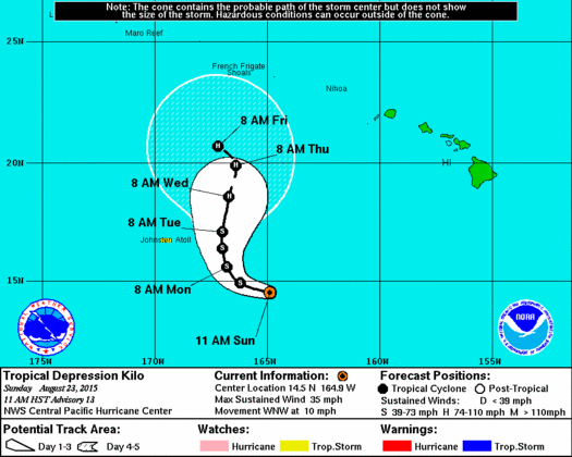
11 am CPHC Kilo track
The Central Pacific Hurricane center continues to advise those living or visiting the Hawaiian Islands in the next several days to monitor the progress of Kilo as these systems can sometimes behave unpredictably.
WEATHER FORECAST –
Deep tropical moisture will remain over the islands for the next several days, thereby fueling locally heavy showers and thunderstorms, and a flash flood watch remains in effect for all islands. Light winds will favor a southeasterly direction for the next several days, with light to moderate trade winds expected to return during the second part of the week. Even when trade winds return, the atmosphere will remain quite moist. Although the latest forecast from the Central Pacific Hurricane Center keeps the center of Kilo several hundred miles west of Kauai later this week, the National Weather Service says you should continue to monitor the latest forecasts.

CPHC 5am track for Kilo
(Updated with information from the CPHC’s 5 a.m. update)
By Meteorologist Malika Dudley
As of the 5 a.m. CPHC update, Kilo has maximum sustained winds near 35 mph with higher gusts. Some strengthening is expected through Monday night and Kilo is forecast to become a tropical storm again later today or tonight when it reaches maximum sustained winds of 39 mph.
The system is located 570 miles SW of Honolulu.
The system is moving west near 15 mph and this general motion should continue today followed by a gradual turn to the northwest with a gradual decrease in forward speed from tonight through Monday.
[flashvideo file=http://www.youtube.com/watch?v=2UfDvkW0FQA /] **Video update shot Saturday 8/22, information is still important and relevant.**
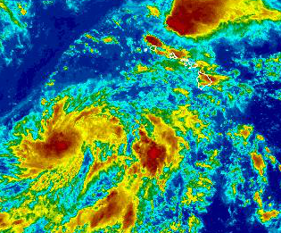
Kilo continues to look ragged on satellite. The center location is a bit iffy based on the disorganized nature of the system on satellite. The ridge that is expected to weaken and steer the system northwest back toward the islands is still forecast to do so.
The biggest change with this update is the track curving north and then northeast near the end of the forecast period. A trough high in the atmosphere is expected to help steer Kilo in that direction. Just how sharp this turn could be depends on how strong the trough gets. We will keep an eye on it and bring you the latest.

Kilo satellite imagery. 9 a.m. 8/23/15. Image credit: NOAA/NWS.
The system is over very warm sea surface temperatures that are expected to help fuel the storm and make it stronger. Vertical wind shear is is not very strong. Assuming Kilo can become better organized, we expect strengthening.
A military aircraft is expected to fly through the system late this morning to collect data on Kilo’s location, strength and size. This will give us valuable information in determining whether or not Kilo has been slowly becoming better organized.
WEATHER FORECAST –
A Flood Watch remains in effect until 6 p.m. Monday for all islands. An unstable and very moist air mass on the back side of the tropical system is lingering across the state. This moisture interacting with the land is expected to produce periods of heavy rain and slow-moving downpours that could lead to flash flooding. If that occurs a more urgent Flood Advisory (flooding is imminent) or Flood Warning (flooding is occurring) will be posted by the National Weather Service.
Additionally, a Marine Weather Alert is posted for mariners. The NWS says to be prepared to encounter visibility near zero in very heavy showers and to be alert for dangerous cloud to surface lightning strikes. If caught on the open water during a thunderstorm, stay below deck. Thunderstorms also have the ability to produce sudden waterspouts which can easily overturn small boats and create locally hazardous seas.

Tropical storm wind speed probabilities as of 5 a.m. August 23, 2015
Information from the latest NWS forecast discussion: The surface winds have switched to a more southeast direction overnight, allowing weak land breezes to develop over the islands. As little change is expected on the overall weather pattern for at least the next couple of days, expect the unsettled weather to prevail across the state, with potential for heavy showers and thunderstorm activity persisting. Possible rainfall totals of 2 to 4 inches with isolated higher amounts are expected. Therefore a flash flood watch remains in effect for all islands until Monday afternoon.
The overall forecast scenario for this week will still greatly depend on where and how strong Kilo would wound up to be, but at the very least, expect generally cloudy skies with localized heavy downpours possible due to the lingering tropical moisture.
All interests in the state of Hawaii should closely follow the progress of Kilo.
Regardless of the final outcome of Kilo, now is the time to revise your emergency response plans and determine what supplies you may need in case of a tropical cyclone event.
Sponsored Content


