11 p.m. UPDATE: Jimena Eighth Hurricane of E. Pacific Season
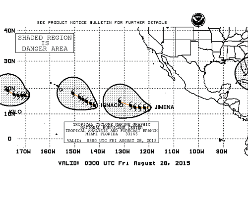
Image: NHC 11 p.m.
***Updated with information from the Central Pacific Hurricane Center and National Huricane Center’s 11 p.m. updates.***
By Meteorologist Malika Dudley
As of the 11 p.m. NHC update, Jimena has held maximum sustained winds near 80 mph with higher gusts.
The system is now the eighth hurricane of the East Pacific hurricane season. Additional strengthening is expected with Jimena becoming a major hurricane by Saturday.

Image: CPHC 11 p.m. Ignacio
The system is moving west at 14 mph and expected to move west-northwest on Saturday.
Hurricane Ignacio has not changed much in intensity, track or forecast guidance since the 5 p.m. update. See details below.
***Updated at 5 p.m.***
By Meteorologist Malika Dudley
Hurricane Ignacio crossed into the Central Pacific this morning making it the eighth tropical cyclone in the Central Pacific basin for the 2015 hurricane season. The system looks a bit more ragged on satellite as compared to this morning but the strength of the system remains unchanged since the last update.
As of the 5 p.m. Central Pacific Hurricane Center advisory Ignacio is a category 1 hurricane with maximum sustained winds near 90 mph. The system is moving west near 13 mph. This general motion is expected to continue during the next couple of days with a slight decrease in forward speed tonight.
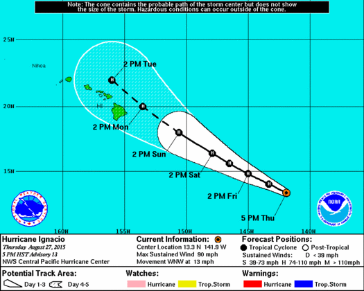
Image: CPHC 5 p.m.
Gradual strengthening is forecast during the next 48 hours, then a weakening trend is expected to begin as the system passes over cooler sea surface temperatures and encounters vertical wind shear. Hurricane force winds extend 25 miles from the center and tropical storm force winds extend 80 miles from the center
The system has been nudged southward of the previous track in this update. The general track remains unchanged with the system traveling in the direction of the Hawaiian Islands.
Meanwhile, tropical storm Jimena is quickly strengthening in the Eastern Pacific. Maximum sustained winds are near 70 mph with additional strengthening expected. Jimena is forecasted to become a hurricane tonight or Friday and a major hurricane on Saturday.
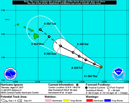
Image: CPHC track at 11 a.m.
(Updated with information from the 11 a.m. NHC advisory)
By Meteorologist Malika Dudley
Hurricane Ignacio crossed into the Central Pacific this morning making it the eighth tropical cyclone in the Central Pacific basin for the 2015 hurricane season.
As of the 11:00 a.m. Central Pacific Hurricane Center advisory Ignacio is a category 1 hurricane with maximum sustained winds near 90 mph. The system is moving west near 13 mph. This general motion is expected to continue during the next couple of days.
Gradual strengthening is forecast during the next 48 hours and could become a major hurricane on Friday. Weak vertical wind shear and warm sea surface temperatures will put the system in an environment that is favorable for strengthening.
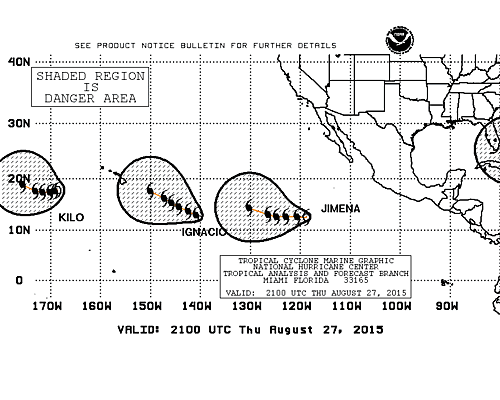
Image: 11 a.m. NHC tracks
After 72 hours, the system is expected to encounter more shear and begin to weaken. Hurricane force winds extend 25 miles from the center and tropical storm force winds extend 90 miles from the center.
The system has been nudged left of the previous track in this update. The general track remains unchanged with the system traveling in the direction of the Hawaiian Islands.
Meanwhile, tropical storm Jimena is quickly strengthening in the Eastern Pacific. Maximum sustained winds are near 60 mph with additional strengthening expected. Jimena is forecasted to become a hurricane tonight or Friday.

Image: NHC
(Updated with information from the 5 a.m. NHC advisory)
By MauiNOW Staff
Hurricane Ignacio is expected to enter the Central Pacific at some point Thursday, according to the National Hurricane Center’s 5 a.m. advisory.
Ignacio was 1,135 miles east-southeast of Hilo, moving in a west-northwest direction at about 13 miles per hour with growing strength.
Maximum sustained winds have increased to 90 mph with expected strengthening in the forecast over the next 48 hours. It has the potential to become a major hurricane on Friday.
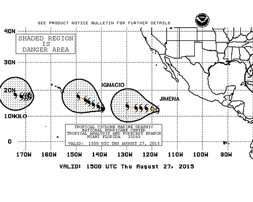
Image: NHC
Following the next 48 hours, the storm is expected to encounter increasing western shear and move to slightly cooler water that will be conducive to gradual weakening.
NHC continues to monitor Tropical Storm Jimena, located just off the coast of Mexico and about 890 miles southwest of the southern tip of Baja, Calif., traveling at 17 mph in a west-northwest direction.
Maximum sustained winds for the storm were 45 mph, as of 5 a.m.
Forecasts predict that the storm will take a turn toward the west at some point Thursday and decrease in forward speed.
The storm is expected to strengthen and become a hurricane on Friday.
Sponsored Content