

UPDATE: T.S. Oho to Become Hurricane, T.D. 8-C Forms Overnight
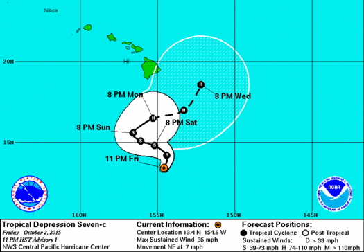
Image: CPHC 5 a.m. track Tropical Storm Oho
***Updated with information from the CPHC’s 5 a.m. update on 10/3/15***
By Meteorologist Malika Dudley
We have set a record for the number of tropical cyclones in the Central Pacific with 13 systems having formed within the basin this season.
Tropical Depression 7-C has strengthened and is now Tropical Storm Oho. The system is now 340 miles south of South Point. At 5 a.m. the system was moving northeast at about 6 mph. Forward motion is forecast to be slow, around 5 mph for the next few days. This motion should continue through today with a turn to the west-northwest expected tonight and Sunday.
The track itself is very dynamic and complex relying on a series of events happening in the atmosphere that will steer the system back and forth. We’ll have to keep an eye on this one with uncertainty being higher than usual with regard to the track because of all the different potential influences.
Maximum sustained winds are near 40 mph at this hour and expected to increase with significant intensification forecast over the next couple of days. Oho should become a hurricane by early Monday as satellite is showing the system continuing to organize. Light shear and warm ocean waters are expected to surround Oho for the next couple of days.
Tropical storm force winds extend 35 miles from the center. There are no coastal alerts posted at this time however, a Tropical Storm Warning is posted for our offshore waters at this time.
Hurricane hunters are scheduled to fly through the system Sunday evening and Monday morning. This will give us valuable information about Oho that we will be sure to pass on to you.
The National Weather Service posted this weather forecast based on the current track.
Increasing moisture and even a few thunderstorms associated with Seven-C could reach the Big Island this evening. Better chances of rain will reside over the E half of the island chain. The forecast will also continue to carry a slight chance of thunderstorms for the Big Island from tonight and through late Sun, and could be expanded into Maui county as new model data becomes available today.
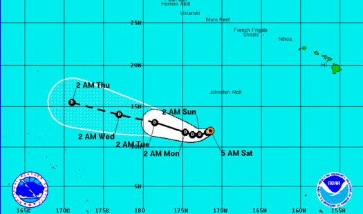
Image: CPHC 5 a.m. track T.D.8C
Tropical Depression 8-C has also formed in the Central Pacific. The track of this system is not expected to affect the Hawaiian islands.
***Posted at 11 p.m. on 10/2/15***
We have set a record for the number of tropical cyclones in the Central Pacific in the 2015 season.
Tropical Depression 7-C has formed 395 miles south of South Point. At 11 p.m. the system was moving northeast at about 7 mph. This motion should continue through early Saturday with a turn to the west-northwest expected that night.

Image: CPHC 11 p.m. track T.D.7C
Maximum sustained winds are near 35 mph at this hour and expected to increase with significant intensification forecast over the next couple of days becoming a hurricane sometime on Monday.
As we’ve seen throughout hurricane season, a lot can change as the system develops. We will continue to monitor the changes and bring you the latest.
Sponsored Content


