

LESTER UPDATES: Lester Continues Weakening
Click here for: MAUI CLOSURE UPDATES
Click here for: 5 a.m. 9.3.16 Video Update with Meteorologist Malika Dudley
Click here for: Maui Potential Impacts
Click here for STORM PREP TIPS
Hurricane Lester has cleared the Hawaiian Islands and all of the related surf and flood warnings and advisories have been lifted. As of 8 a.m. on Sunday, Sept. 4, 2016, Acting Mayor Keith Regan issued a Termination of Emergency Proclamation. Click here for Sunday’s Weather Update from Meteorologist Malika Dudley.
Previous Post:
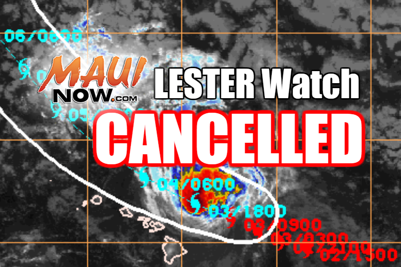
The Hurricane watch that was in effect was cancelled as of 5 a.m. on Saturday, Sept. 3, 2016.
HURRICANE WATCH CANCELLED
(5 p.m.; 11 a.m.; 5 a.m. Update 9.3.16 by Wendy Osher)
The hurricane watch that was in effect for Maui and Oʻahu has since been cancelled as of 5 a.m.
At 5 p.m. on Saturday, Sept. 3, 2016, the center of Hurricane Lester was 150 miles NNW of Hāna; 135 miles N of Kahului; 120 miles N of Kaunakakai; and 140 miles N of Lānaʻi City.
The system maintained maximum sustained winds near 75 mph and continued on a WNW path at 17 mph.
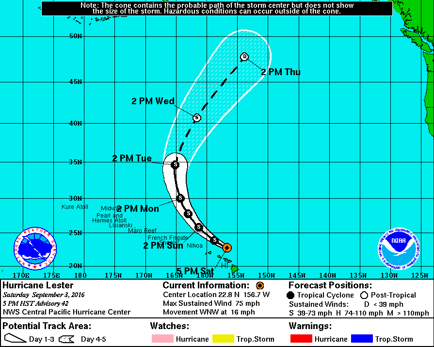
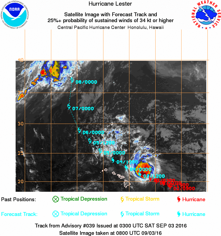
Lester is now a Category 1 Hurricane. Imagery shows the system’s projected track as of 5 p.m. HST on 9.3.16. Background imagery courtesy NOAA/CPH/NWS.
Lester is considered a Category 1 (74-95 mph winds) Hurricane. Forecasters say Lester should change course to a more northwesterly track over the next 72 hour period and continue to weaken.
The CPHC says the forecast calls for Lester to weaken into a tropical storm on by Sunday, with a transition expected early next week as Lester becomes absorbed into a large trough.
Hurricane-force winds extend outward up to 10 miles from the center and tropical-storm-force winds extend outward up to 125 miles.
“Despite the expectation that hurricane or tropical storm conditions will remain just north of the Islands, large and dangerous surf is expected through the weekend,” the agency reported. The CPHC is reporting that surf of 15-25 feet is peaking with higher sets along the east facing shores today. The surf is expected to drop back down tonight through Sunday. In the meantime, a High Surf Warning remains in effect for the East facing shores through 6 a.m. on Sunday for Maui and Molokaʻi.
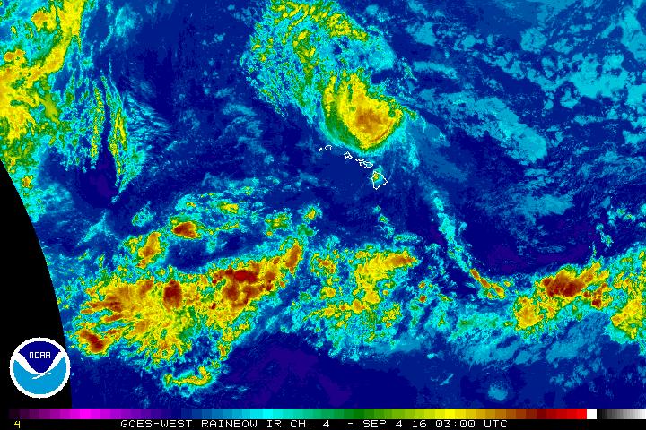
The National Weather Service says locally heavy showers or thunderstorms are possible this weekend as Lester passes north of the Hawaiian Islands, but at this time, there are no watches or warnings in effect.
“Although Lester appears to have spared the islands any major impacts, we are still in hurricane season,” agency officials said. The public is encouraged to be prepared.
As of 5p.m., Lester was located: 220 miles NNW of Bradshaw AAF; 235 miles NNW of Hilo; 215 miles NNW of Kailua-Kona; 275 miles NNW of South Point; 150 miles NNW of Hāna; 135 miles N of Kahului; 120 miles N of Kaunakakai; 140 miles N of Lānaʻi City; 130 miles NE of Honolulu; 130 miles NE of Joint Base PHH; 205 miles ENE of Barking Sands; 180 miles ENE of Līhue; 225 miles ENE of Niʻihau; 930 miles ENE of Johnston Atoll; and 1335 miles ESE of Midway.
Below are updates provided by the Central Pacific Hurricane Center and the National Weather Service:
Lester remains a Category 1 Hurricane. Satellite imagery shows the system at 5 p.m. HST on 9.3.16. Imagery courtesy NOAA/CPH/NWS.
DISCUSSION AND 48-HOUR OUTLOOK
(Update provided by Forecaster Powell with the Central Pacific Hurricane Center)
At 5 p.m.HST on Saturday, Sept 3, 2016 (0300 UTC), the center of Hurricane Lester was located near latitude 22.8 North, longitude 156.7 West. Lester is moving toward the west-northwest near 17 mph (28 km/h) and this motion is expected to gradually become northwesterly tonight through Monday afternoon.
Maximum sustained winds are near 75 mph (120 km/h) with higher gusts. Some weakening is forecast through Monday afternoon.
Hurricane-force winds extend outward up to 10 miles (20 km) from the center and tropical-storm-force winds extend outward up to 125 miles (205 km).
The estimated minimum central pressure is 991 mb (29.27 inches).
HAZARDS AFFECTING LAND
(Update provided by Forecaster Powell with the Central Pacific Hurricane Center)
SURF: Swells generated by Lester will cause large and dangerous surf across exposed shorelines of the Hawaiian Islands through tonight.
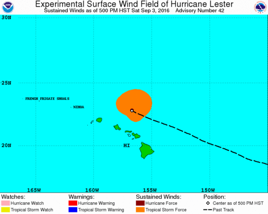
Lester remains a Category 1 Hurricane. Wind probability imagery shows the system at 5 p.m. HST on 9.3.16. Imagery courtesy NOAA/CPH/NWS.
HURRICANE LESTER DISCUSSION NUMBER 40
NWS CENTRAL PACIFIC HURRICANE CENTER HONOLULU HI
(Update provided by Forecaster Powell with the Central Pacific Hurricane Center)
5 p.m. HST SAT SEP 03 2016
Shear continues to take its toll on Lester’s satellite presentation this afternoon, with the southern portion of the LLCC briefly becoming exposed around 0000 UTC. Deep convection persists across the northern semicircle, with warmer convective tops noted in the -58 to -65 degrees Celsius range. Subjective Dvorak satellite intensity estimates range from 3.5/55 kt from SAB, to 4.0/65 kt from PHFO to 4.5/77 kt from JTWC. U.S. Air Force reconnaissance aircraft finished their last mission this morning, so we will assign Lester an initial intensity of 65 kt based on an average of the Dvorak estimates and the overall degraded satellite appearance.
Initial motion is unchanged at 295/15 kt. Track guidance remains tightly packed, taking Lester along a recurving path generally northwestward through day 2, followed by a turn northward on day 3, then northeastward on days 4 and 5. The subtropical ridge north of 30N provides most of the steering needed to keep Lester moving west northwestward, while an upper trough northwest of the main Hawaiian Islands allows this system to slip northward. This upper trough merges with a larger longwave upper trough near the dateline by the end of day 2, subjecting Lester to the strong southwest to northeast steering needed for recurvature. The forecast track closely follows the last one along the TVCN consensus path. The Ocean Prediction Center coordinated with the days 4 and 5 positions.
All intensity guidance show Lester weakening through day 5 as this system passes over cooler water and the current 15 to 20 kt of southwesterly shear increases. Like last time, the global models, notably GFS, keep Lester stronger at all tau than HWRF of GFDL. The forecast calls for Lester to weaken at a steady rate between LGEM and IVCN consensus guidance.
Large and dangerous surf is expected through tonight across exposed shores in the main Hawaiian Islands. Refer to the latest coastal hazard message (CFWHFO) from the National Weather Service in Honolulu, HI for additional information.
_______________________________________
Previous Post:
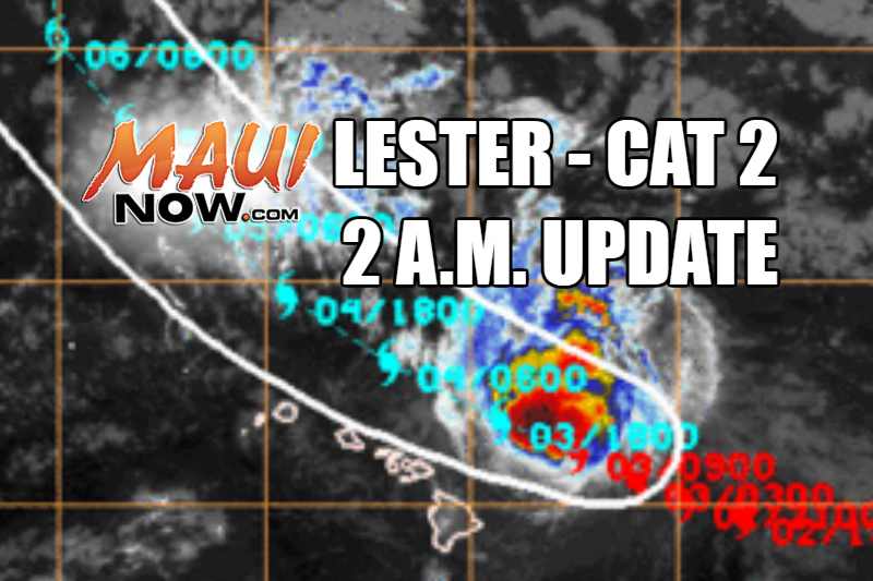
Lester. 2 a.m. on 9.3.16. Image credit: NOAA/NWS/CPHC
HURRICANE WATCH ISSUED FOR LESTER: (By Wendy Osher)
Hurricane Lester remains a Category 2 system as of the 2 a.m. (Saturday, Sept. 3, 2016) advisory issued by the Central Pacific Hurricane Center. The official forecast keeps the center northeast of the islands; however forecasters say any move to the west of the current track, could bring dangerous impacts to the state AND impacts from hurricanes can occur well away from the center.
This morning, the Central Pacific Hurricane Center discontinued the Hurricane Watch that was in place for the Big Island. Watches remain in place for Maui and Oʻahu.
According to the latest forecast, Lester has already reached its peak intensity as a Category 3 hurricane on Thursday. It remains a Category 2 (96-110 mph winds) system. Forecasters say continued weakening trend is forecast due in part to increasing vertical wind shear.
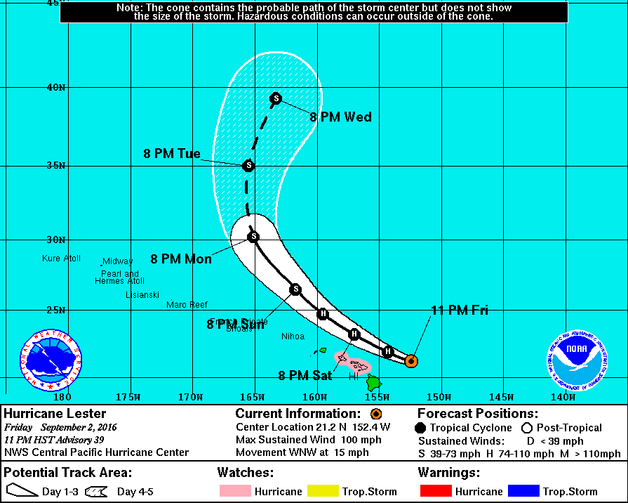
Lester is a Category 2 Hurricane. Imagery shows the system’s projected track as of 11 p.m. HST on 9.2.16. Background imagery courtesy NOAA/CPH/NWS.
At 2 a.m. on Saturday, Sept. 3, the system had maximum sustained winds near 100 miles per hour and was moving to the WNW at 15 mph. Lester was last located about 185 miles ENE of Hāna and
215 miles E of Kahului, Maui. Heavy rain associated with Lester may impact Maui and Oʻahu late tonight into Sunday.
Many businesses closed early on Friday in preparation for potential impacts. All non-essential employees with the county were released at noon on Friday. A full list of closures and postponed and cancelled events due to the inclement weather is available on our website.
At 11:49 p.m., the CPHC said the probability of Tropical Storm Conditions is at 11% in Kahului and Hāna, 8% in Lānaʻi City, and 13% in Kaunakakai. *This represents a general downward trend since the last forecast. Forecasters with the CPHC say “probabilities for tropical storm and hurricane conditions have been dropping slowly. If this trend continues, the Hurricane Watch may be cancelled with the next advisory package.” The next full forecast update will be issued at 5 a.m. Right now Watches remain in effect for Maui County and Oʻahu.
The National Weather Service says that although the latest forecast is for sustained winds to remain below tropical storm force of 39 mph, “only a small change in the track of Lester could result in higher winds during the time Lester will make its closest approach.”
The CPHC says the most significant impact from Lester is expected to be “very large and damaging surf” along east facing shores. Surf is expected to peak at 20 to 25 feet along east facing shores Friday night into Saturday and diminishing on Sunday.
As of 2 a.m., Lester was located: 195 miles NE of Bradshaw AAF; 170 miles NE of Hilo; 220 miles ENE of Kailua-Kona; 240 miles NE of South Point; 185 miles ENE of Hāna; 215 miles E of Kahului; 245 miles E of Kaunakakai; 245 miles E of Lānaʻi City; 305 miles E of Honolulu; 305 miles E of Joint Base PHH; 425 miles E of Barking Sands; 395 miles E of Līhue; 445 miles E of Niʻihau; 1115 miles ENE of Johnston Atoll; and 1575 miles ESE of Midway.
Forecast Track Info: The CPHC says Lester is forecast to pass approximately 125 miles to the NE of the islands this weekend, with a pass above Maui County on Saturday. Gradual weakening is forecast over the next several days. The agency says there’s still a possibility that Lester could drift west of the current track. “Although the forecast currently keeps the stronger winds and heaviest rains offshore, our local weather will be highly dependent on the exact track that Lester takes as it passes by this weekend. Only a small error on the left side of the forecast track would bring a significantly greater threat of damaging winds and flooding rains to the islands.”
Below are updates provided by the Central Pacific Hurricane Center and the National Weather Service:
Lester is a Category 2 Hurricane. Satellite imagery shows the system at 1 a.m. HST on 9.3.16. Background imagery courtesy NOAA/CPH/NWS.
WATCHES AND WARNINGS: (Update provided by Forecaster Jelsema/R Ballard with the CPHC/NWS)
A Hurricane Watch is in effect for: Maui County including the islands of Maui, Molokaʻi, Lānaʻi and
Kahoʻolawe; and Oʻahu. A Hurricane Watch means that hurricane conditions are possible within the watch area. In this case, conditions are possible in the next 18 to 36 hours.
DISCUSSION AND 48-HOUR OUTLOOK: (Update provided by Forecaster Jelsema/R Ballard with the CPHC/NWS)
At 2 a.m. HST (1200 UTC), the center of Hurricane Lester was located by US Air Force Reserve Hurricane Hunter aircraft near near latitude 21.5 North, longitude 153.2 West. Lester is moving toward the west-northwest near 15 mph (24 km/h). This general motion is expected to continue through Saturday night with a gradual turn toward the northwest expected on Sunday.
Maximum sustained winds are near 100 mph (155 km/h) with higher gusts. Gradual weakening is forecast during the next 48 hours.
Hurricane-force winds extend outward up to 45 miles (75 km) from the center and tropical-storm-force winds extend outward up to 150 miles (240 km).
The estimated minimum central pressure is 982 mb (29.00 inches).
HAZARDS AFFECTING LAND: (Updated provided by Forecaster Jelsema/R Ballard with the CPHC/NWS)
WIND: Hurricane conditions are possible over Maui County and Oʻahu late Saturday or Saturday night, and tropical storm conditions are possible as early as Saturday afternoon.
SURF: Large swells generated by Lester will build across Hawaiian waters tonight and Saturday. Surf generated by these swells will peak during the weekend across the main Hawaiian Islands, becoming very large and possibly damaging along exposed shorelines.
RAIN: Heavy rains associated with Lester may impact Maui county and Oʻahu Saturday and Sunday. (*Forecasters deep tropical moisture around hurricane Lester will result in increasing showers tonight for Maui county, with the possibility of localized heavier downpours or thundershowers developing this weekend. However, the threat of heavy rain and flooding would be greater if Lester moves farther to the west than currently forecast.)
Lester. 10 p.m. on 9.2.16. Image credit: NOAA/NWS/CPHC
DISCUSSION AND 48-HOUR OUTLOOK (Updated by Forecaster Jelsema/R Ballard with the CPHC/NWS)
11 p.m.HST FRI SEP 02 2016
The satellite presentation of Lester has degraded since the previous advisory, with the eye no longer visible. US Air Force reconnaissance aircraft was very helpful in determining the center location of the system as it becomes increasingly tilted due to southwesterly vertical wind shear. The hurricane hunters found SFMR winds of 82 knots in the southwest quadrant and 79 knots in the northwest quadrant. Due to sampling considerations, the initial intensity will be set to 85 knots for this advisory.
The initial motion is toward the west-northwest at 13 knots. This motion is expected to continue through Saturday as Lester continues to be steered by deep layered ridging to the north of the system and an upper level trough near 160W. Beginning Saturday night, Lester will begin to round the southwestern periphery of the deep layered ridge, while an upper level trough approaches Midway Atoll. As a result, Lester should change course to a more northwesterly track through 72 hours, then move toward the north through 120 hours in between the deep layered ridge to the east and the upper trough to the west. The official CPHC track is very close to the previous advisory through 72 hours and then to the right of the previous track through 120 hours. This adjustment to the track is a result of a guidance shift and is very close to the multi-model consensus TVCN and GFS/ECMWF consensus (GFEX).
Lester is expected to gradually weaken over the next couple days it begins to experience increasing southwesterly vertical wind shear while moving over marginal 26 to 27C sea surface temperatures. The official intensity forecast is very close to the previous advisory and is closely aligned with SHIPS and IVCN guidance. The forecast calls for Lester to weaken into a Tropical Storm on Sunday, with an extra-tropical transition expected to occur early next week.
A Hurricane Watch remains in place for Oahu and Maui County, as the official forecast still brings the system close to portions of the main Hawaiian Islands. Model guidance has been stable for the past couple of days, and probabilities for tropical storm and hurricane conditions have been dropping slowly. If this trend continues, the Hurricane Watch may be cancelled with the next advisory package.
Sponsored Content


