

Friday Weather Forecast, Potential Lester Impacts
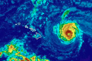
Image: NWS satellite at 8 a.m.
Here is a summary of the expected weather conditions for Maui County as Madeline departs and Lester approaches. Meteorologist Malika Dudley will be doing LIVE weather updates on our MauiNow.com Facebook page. Here is a link to the 5 a.m. video forecast.
Click here for a list of continually updated closures and cancellations due to Lester.
Latest on Lester – updated throughout the day.
Today’s Weather
Partly sunny skies today with scattered windward showers and isolated leeward showers. Winds out of the northeast from 15 – 25 mph and gusting to 35 mph. Tonight we expect mostly cloudy skies with showers likely in windward areas and scattered showers for leeward spots. Northeasterly winds are forecast from 15 to 25 mph with gusts up to 40 mph for our windier spots.
Labor Day Weekend
Based on our current forecast track for Lester, Saturday we expect mostly cloudy skies with showers likely. Winds should be out of the southwest from 15 to 30 mph with gusts up to 45 mph. Sunday cloudy skies and some haze are in the forecast for Maui County with showers likely in windward spots and scattered leeward showers. Winds will be out of the east around 15 mph. Improving conditions are expected Sunday with weather getting back to typical trade wind weather on Monday.
Lester Weather Effects
According to the Central Pacific Hurricane Center, on our current forecast track, hurricane Lester is forecast to pass approximately 125 miles to the northeast of the islands this weekend. Lester will pass Maui county on Saturday. The hurricane is expected to gradually weaken during the next couple of days.
The most significant impact from Lester is expected to be very large and damaging surf along east facing shores.
There is still a possibility that Lester could drift west of the current forecast track. Although the forecast currently keeps the stronger winds and heaviest rains offshore, our local weather will be highly dependent on the exact track that Lester takes as it passes by this weekend. Only a small error on the left side of the forecast track would bring a significantly greater threat of damaging winds and flooding rains to the islands. A hurricane watch remains in effect for Maui, Molokai, Lāna’i, Kahoolawe.
WIND:
HURRICANE WATCH – Maui, Molokai, Lāna’i, Kaho’olawe, all coastal waters
Tropical storm conditions (39 mph +) are possible as early as late Friday. The chance for tropical storm conditions at Kahului is 30%, Hāna is 33%, Lāna’i City is 23% and Kaunakakai is 29%. This is significantly lower than yesterday’s forecast.
Although the latest forecast is for sustained winds to remain below tropical storm force of 39 mph, only a small change in the track of Lester could result in higher winds during the time Lester will make its closest approach.
RAIN:
Deep tropical moisture around hurricane Lester will result in increasing showers tonight for Maui county, with the possibility of localized heavier downpours or thundershowers developing this weekend. However, the threat of heavy rain and flooding would be greater if Lester moves farther to the west than currently forecast and lesser if Lester moves farther east and away from the islands.
SURF:
A High Surf Advisory is posted through 6 p.m. Friday.
A High Surf Warning is posted from 6 p.m. Friday through Saturday at 6 p.m.
Very large and damaging surf, with peak waves of 20 to 35 feet, is expected along east facing shores Friday night into Saturday and diminishing on Sunday. These waves, in combination with a possible storm surge of 1 to 2 feet, may cause significant wave runup or damage to coastal properties and infrastructure, including roadways. Powerful longshore and rip currents will be present at most beaches. Large breaking waves and strong currents may impact harbor entrances and channels causing challenging marine navigation.
Sponsored Content


