

Surf Report: NNW Building, SSW Swell Continues

Image: Asa Ellison
Alerts (as of 1:00 a.m.)
High Surf Advisory: East facing shores of Molokai and Maui until 6 p.m. Wednesday.
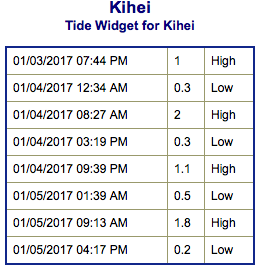
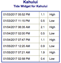
**Click directly on the images below to make them larger. Charts include: Maui County projected winds, tides, swell direction & period and expected wave heights.**
 Maui Surf Forecast
North: Surf is overhead with the best breaks getting up to double overhead on the sets.
West: Surf is pretty knee/waist high today for most westerly exposures with the best breaks up to chest high on the sets.
South: Surf is pretty knee/waist high today for most westerly exposures with the best breaks up to chest high on the sets.
 A north-northwest builds in through early Wednesday and peaks in the middle of the day before fading through Thursday. A smaller west-northwest is also filtering in on Wednesday and peaking Thursday. The north-northwest swell will shift from the northeast first will fill in for the second half of the work week and the second is forecast for the first half of next week.
Our current south-southwest swell will peak on Wednesday but hold much of its size through Thursday morning before fading Thursday afternoon and Friday. Another swell is lining up for the 11th through 13th.
Keep in mind, surf heights are measured on the face of the wave from trough to crest. Heights vary from beach to beach, and at the same beach, from break to break.
**Click here for your detailed Maui County weather report.**
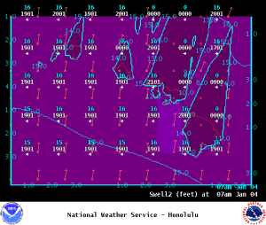
Image: NOAA
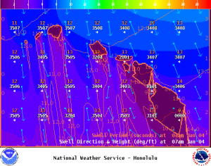
Image: NOAA
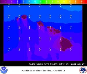
Image: NOAA
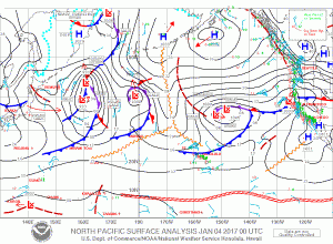
Image: NOAA
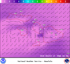
Image: NOAA

Image: NOAA
Sponsored Content


