

Pedestrian Plan Identifies 7 Maui Areas of Concern
By Wendy Osher
The state Department of Transportation has identified seven areas of concern in Maui County for pedestrians.
The findings were released in the department’s Draft Statewide Pedestrian Master Plan, which is available for public viewing and comment through the end of this month.
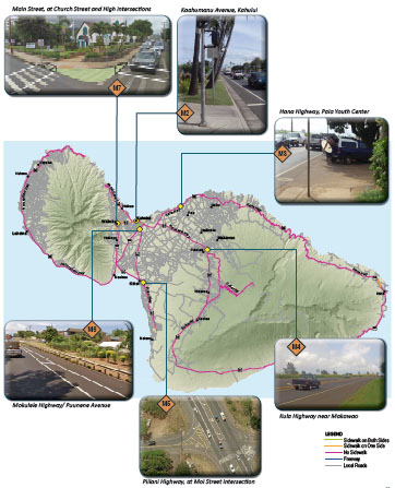
Mapped areas of concern on Maui Island, image courtesy State of Hawaii, Department of Transporation, Draft Statewide Pedestrian Master Plan.
The areas of concern on Maui include the following:
Paia, Hana Highway, Paia Youth Center:
- Concern: A high number of pedestrian-related accidents were reported in this particular area outlined by the state Department of Transportation. Authorities say that between 2004 and 2008, there have been four pedestrian-related accidents in this study area, primarily at the intersection of Hana Highway and Baldwin Avenue. Another concern raised was the use of the Hana Highway shoulder for parking, which results in blocked access for pedestrians near the Paia Youth Center.
- Recommendation: Proposals call for a connection between the end of the existing sidewalk on Hana Highway near Paia Town to the multi-use trail at Paia Youth Center’s parking entrance, as well as the installation of pedestrian signs at the existing crosswalk.
Wailuku: Main Street Intersections with Church and High Streets
- Concern: Transportation officials say the design of the intersections allows for vehicles to turn onto or off of Main Street at relatively high speeds. This feature also reduces the amount of time that pedestrians and drivers have to react to the presence of one another. In addition, the high level of turning movements at the Main and High Street intersection can be confusing for pedestrians, according to the draft report.
- Recommendation: Perform possible traffic signal modification at Main Street and High Street intersection and possible reduction of the curb radii at the Main Street and Church Street intersection to reduce vehicle speeds.
Kahului: Ka’ahumanu Avenue near Kahului Harbor
- Concern: The transportation report also identified an area along Ka’ahumanu Avenue where the sidewalk is discontinuous, creating a gap for pedestrians. Because of the gap, pedestrians end up walking along a private parking lot, in the bike lane, in the landscaping, or cross to the other side of the road. The report also notes that the landscaped areas are not well lit and contain trees and highway signage.
- Recommendation: Add sidewalks or walkways along Kaahumanu Avenue between Wharf Street and Kainani Street, and develop signage for visitors in the area.
Pu’unene: Pu’unene Avenue between Ho’okele and Pu’ukane
- Concern: The report also found a gap in pedestrian connectivity on Pu’unene Avenue between Ho’okele and Pu’ukane Streets. There is currently a two-way bike lane that runs along the makai side Pu’unene Avenue, ending at the Ho’okele Street intersection. There is also an existing shared use path along Pu’unene starting at the Pu’ukani Street intersection. The gap is between the two intersections.
- Recommendation: Connect the pedestrian gap between Hookele and Puukane Street.
Kihei, Piilani Highway, at Moi Street intersection:
- Concern: Another area of concern is a crosswalk that does not have a signal, and lacks advance signage warning drivers of the potential presence of pedestrians. The marked crosswalk walk is located on the south side of the intersection of Piilani Highway (Highway 31) and Moi Place.
- Recommendation: Install advance signage and stop bars to warn drivers of the potential pedestrian presence.
Makawao/Pukalani, Kula Highway, near Makawao Avenue:
- Concern: The plan suggests the creation of a biking and walking path separated from vehicle traffic along the Kula Highway. The concern raised involves the lack of a dedicated path for students to walk and bike to schools serving the Makawao and Pukalani communities.
- Recommendation: Construct a shared use path or sidewalk along Kula Highway and Halealaka Highway between Aapueo Parkway and Makawao Avenue.
Molokai, Farrington Avenue, Molokai High School:
- Concern: On the Friendly Isle, state Transportation officials say improved pedestrian accommodations would benefit the community and enhance pedestrian connectivity near Molokai High School. The report states that students currently lack dedicated pedestrian facilities to walk to school, as sidewalks transition into shoulders just past the high school.
- Recommendation: Construct a dedicated pedestrian facility for kids to walk to school, from Kalae Highway to Molokai High School.
As part of the solution for the areas of concern, Transportation officials have suggested the incorporation of education an enforcement to support recommended improvements.
Sponsored Content


