

Island forecast
Kahului, Maui Weather
Clear daily guidance, radar access and the latest regional weather reporting in one place.
Multi-day outlook
Forecast timeline
Scroll for the full forecast
Tonight
Thursday
Thursday Night
Friday
Friday Night
Saturday
Saturday Night
Sunday
Sunday Night
Monday
Monday Night
Tuesday
Tuesday Night
Wednesday
Latest Weather News

Governor submits request for Presidential Disaster Declaration following devastating kona low storms
Flood Watch through this afternoon
Flood Warning for Big Island through 3:45 p.m.; Flood Watch for Hawaiʻi Island through this afternoon

County of Maui kona storm 2 recap: Midday update on March 23, 2026
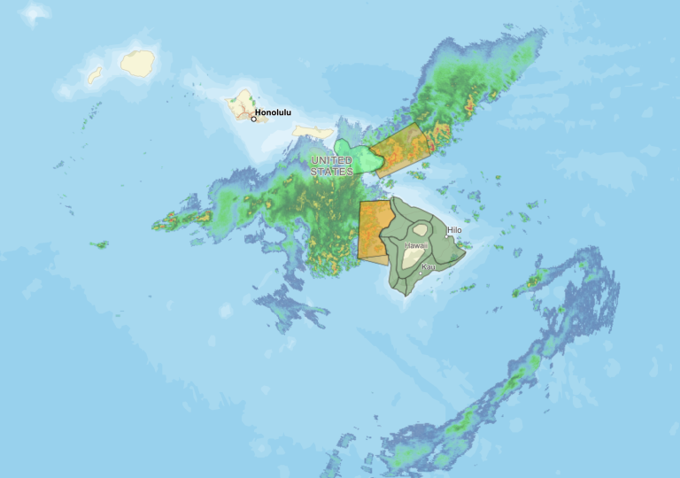
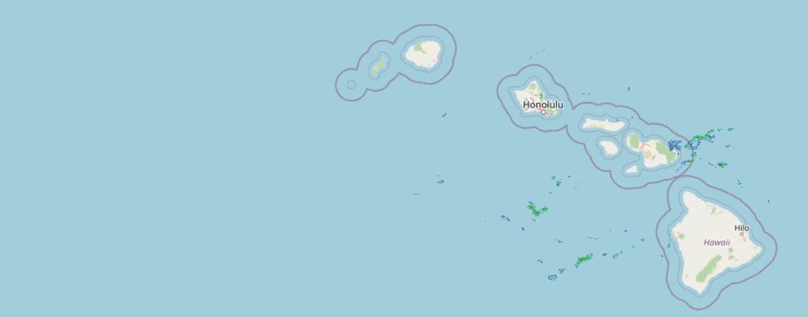 Weather Radar
Regional forecast
Regional Maui Weather Forecast March 25, 2026

West Side
Today: Mostly sunny. Breezy. Scattered showers in the morning, then isolated showers in the afternoon. Highs 71 to 77. Northeast winds 10 to 20 mph. Chance of rain 40 percent.
Tonight: Partly cloudy. Breezy. Scattered showers in the evening, then isolated showers after midnight. Lows 62 to 68. Northeast winds 10 to 20 mph. Chance of rain 40 percent.
Thursday: Sunny. Isolated showers in the morning. Highs 72 to 77. Northeast winds up to 15 mph. Chance of rain 20 percent.
South Side
Today: Sunny and breezy. Highs around 78. Northeast winds 15 to 25 mph.
Tonight: Mostly clear. Breezy. Lows 62 to 70. Northeast winds 10 to 20 mph.
Thursday: Sunny and breezy. Highs around 79. North winds 10 to 20 mph.
North Shore
Today: Breezy. Showers in the morning, then showers likely in the afternoon. Highs around 75 near the shore to around 61 near 5000 feet. East winds up to 20 mph. Chance of rain near 100 percent.
Tonight: Mostly cloudy. Showers likely in the evening, then scattered showers after midnight. Lows around 67 near the shore to around 49 near 5000 feet. East winds up to 15 mph. Chance of rain 70 percent.
Thursday: Mostly cloudy with showers likely in the morning, then mostly sunny with scattered showers in the afternoon. Highs around 76 near the shore to around 61 near 5000 feet. East winds up to 15 mph shifting to the northeast in the afternoon. Chance of rain 70 percent.
Central Maui
Today: Mostly sunny. Breezy. Scattered showers in the morning, then isolated showers in the afternoon. Highs around 76. Northeast winds 15 to 20 mph. Chance of rain 40 percent.
Tonight: Breezy. Partly cloudy with isolated showers. Lows around 65. Northeast winds 10 to 20 mph. Chance of rain 20 percent.
Thursday: Sunny. Isolated showers in the morning. Highs 75 to 80. Northeast winds 10 to 15 mph. Chance of rain 20 percent.
Upcountry
Today: Mostly sunny with scattered showers. Highs around 56 at the visitor center to around 64 at the summit. Northeast winds up to 10 mph. Chance of rain 50 percent.
Tonight: Mostly clear with scattered showers. Lows 38 to 52. East winds up to 10 mph. Chance of rain 50 percent.
Thursday: Sunny. Scattered showers in the morning, then isolated showers in the afternoon. Highs around 57 at the visitor center to around 64 at the summit. Light winds. Chance of rain 50 percent.
East Maui
Today: Breezy. Showers in the morning, then showers likely in the afternoon. Highs around 75 near the shore to around 61 near 5000 feet. East winds up to 20 mph. Chance of rain near 100 percent.
Tonight: Mostly cloudy. Showers likely in the evening, then scattered showers after midnight. Lows around 67 near the shore to around 49 near 5000 feet. East winds up to 15 mph. Chance of rain 70 percent.
Thursday: Mostly cloudy with showers likely in the morning, then mostly sunny with scattered showers in the afternoon. Highs around 76 near the shore to around 61 near 5000 feet. East winds up to 15 mph shifting to the northeast in the afternoon. Chance of rain 70 percent.
Lanai City
Today: Sunny and windy. Isolated showers in the afternoon. Highs 66 to 74. Northeast winds 25 to 30 mph. Chance of rain 20 percent.
Tonight: Clear and breezy. Lows around 61. Northeast winds 20 to 25 mph.
Thursday: Sunny and breezy. Highs 67 to 75. Northeast winds 15 to 25 mph.
Kaunakakai
Today: Breezy. Mostly sunny with isolated showers. Highs 63 to 79. Northeast winds 10 to 25 mph. Chance of rain 20 percent.
Tonight: Mostly clear. Breezy. Isolated showers in the evening, then scattered showers after midnight. Lows 54 to 68. Northeast winds 10 to 25 mph. Chance of rain 40 percent.
Thursday: Sunny and breezy. Isolated showers in the morning. Highs 64 to 80. Northeast winds 10 to 20 mph. Chance of rain 20 percent.
Detailed Forecast
Synopsis
A drier and more stable trade wind pattern is expected through the weekend and into early next week. Showers should be mostly focused along windward and mauka locations through the period.
Discussion
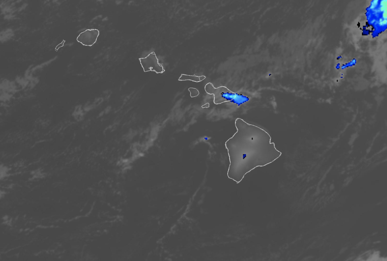
Looking at radar and satellite, typical trade wind clouds are streaming in from the east-northeast. Expect scattered windward and mauka showers across all islands for the next several days especially in the late evening and overnight hours. Northeast winds will remain elevated and gusty through tonight but should begin to ease some tomorrow into tomorrow evening.
An upper low will swing by to the northeast and push a fairly dry cold front through Thursday night through Saturday night, bringing even more drier air to the state. At this time, the forecast is for dewpoints in the mid 50s Saturday night, with upper 50s both Friday and Sunday nights. Looks like a cool weekend in store.
Aviation
Mostly dry and breezy northeast trade wind conditions will prevail across the island chain over the next 24 h. As a result, AIRMET Tango continues for low-level turbulence across leeward areas of all islands. Brief periods with MVFR CIGS/VSBYS are possible in passing showers, mostly through the early morning hours today.
Marine
A low pressure system north-northeast of the islands and a high pressure system to the north-northwest of the Hawaii region will keep northeasterly trade winds in the forecast through the week.A Small Craft Advisory (SCA) has decreased in coverage to most eastern coastal waters through early Thursday morning for winds. Winds will briefly ease on Thursday and Friday, likely falling below SCA thresholds. A new high pressure develops far northwest of Hawaii by Friday night, strengthening trade winds into the fresh to strong range this weekend with returning SCA conditions from Saturday into the first half of next week.
A short to medium period north-northeast swell will slowly decline today. The forerunners of another small northwest swell will arrive at the buoys later today, with the medium period swell peaking around 3 feet on Thursday, before gradually declining through the weekend. For east facing shores, short period wind wave energy from northeasterly trade winds will hold into the weekend. Strengthening northeasterly winds this weekend and potential gales associated with a low around one thousand miles northeast of the islands will lead to the potential for high surf advisories along north and east facing shores from Sunday into early next week.
For south facing shores, small background energy pulses will keep surf heights just above flat conditions into early next week.
HFO Watches/Warnings/Advisories
Small Craft Advisory until 6 AM HST early this morning for Kauai Northwest Waters, Kauai Windward Waters, Kauai Leeward Waters, Kauai Channel, Oahu Windward Waters, Oahu Leeward Waters, Kaiwi Channel, Maui County Windward Waters.
Small Craft Advisory until 6 AM HST Thursday for Maui County Leeward Waters, Maalaea Bay, Pailolo Channel, Alenuihaha Channel, Big Island Windward Waters, Big Island Leeward Waters, Big Island Southeast Waters.
Check out their Maui Helicopter Tours today!
Data Courtesy of NOAA.gov


