

New NW Sunday, Possible XL Swell Wednesday

image: Chris Archer
Alerts (as of 1:00 a.m.)
A Small Craft Advisory is expected for all Maui County waters from 2 p.m. this afternoon to 6 p.m. Sunday with winds from 25 to 30 mph and seas up to 12 feet.
A Wind Advisory may be posted later tonight or tomorrow.
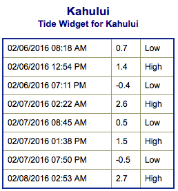
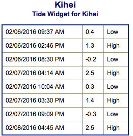
**Click directly on the images below to make them larger. Charts include: Maui County projected winds, tides, swell direction & period and expected wave heights.**
 Maui Surf Forecast
North: Wave heights are waist/shoulder high at the best spots and easing through the day. The best breaks could get up to head high on the best tides.
West: Wrap from the northwest swell affecting some western shores today will continue to taper off. Spots with northern exposure could get up to waist/shoulder high.
South: Wave heights are waist high or less today out of the south-southwest. Many spots will be flat.
 Another northwest swell is expected to quickly fill in Sunday and hold through early next week up to well overhead. A solid large northwest swell is expected to build Wednesday into Thursday. It has potential to be XL or even XXL, will keep an eye on the models.
Not much expected out of the SPAC the next few days. A small swell could fill in starting Monday/Tuesday, peak Tuesday before fading back down.
Keep in mind, surf heights are measured on the face of the wave from trough to crest. Heights vary from beach to beach, and at the same beach, from break to break.
**Click here for your detailed Maui County weather report.**
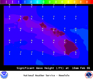
Image: NOAA /NWS
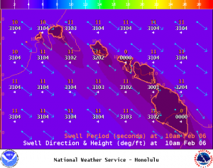
Image: NOAA /NWS
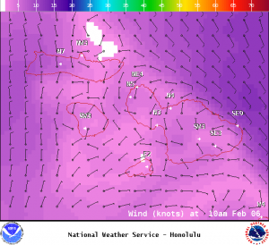
Image: NOAA /NWS

Image: NOAA /NWS
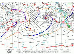
Image: NOAA /NWS
Sponsored Content


