

TROPICAL STORM FELICIA WEAKENING RAPIDLY, 555 MILES EAST OF HILO
INTERMEDIATE ADVISORY #24A
(Updated @ 8 a.m. Sun. August 9, 2009 by Wendy Osher)
Tropical storm Felicicia is weakening rapidly as it heads toward the Hawaiian islands.
A Tropical Storm Watch remains in effect for the Big Island of Hawaii, and for all of Maui County, which includes the islands of Maui, Molokai, Lanai and Kahoolawe.
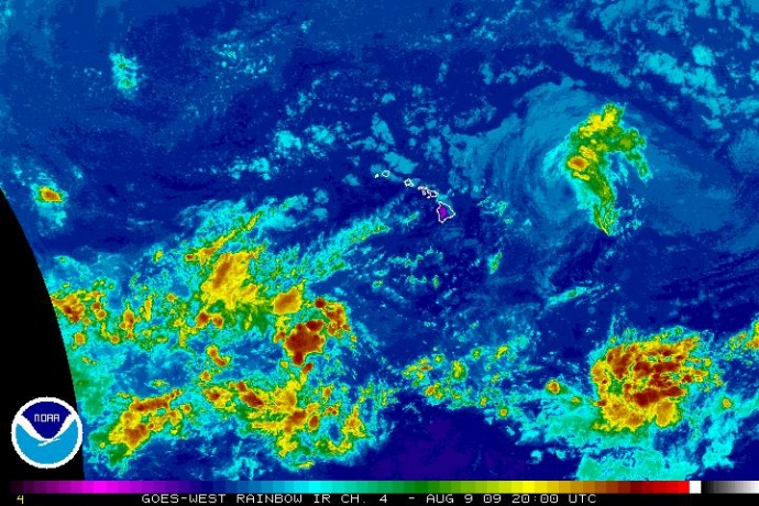
(Click to enlarge Image. Satellite imagery updated at 10 a.m. HST Sunday August 8, 2009. Image courtesy NOAA & the Natioinal Hurricane Center.)
At 8 a.m. HST, the center of Tropical Storm Felicia was located by air force reconnaissance about 555 miles East of Hilo, Hawaii, and about 735 miles East of Honolulu, Hawaii. (Latitude 20.9 North, and Longitude 146.5 West).
Felicia is moving toward the west-northwest near 14 mph, and this general motion is expected to continue for the next couple of days. The center of Felicia is expected to be near, or over the Hawaiian Islands by late Monday.
The maximum sustained winds, based on aircraft data, are near 55 mph with higher gusts. Additional weakening is forecast during the next couple of days.
Tropical Storm force winds extend outward up to 105 miles from the center. The minimum central pressure was 1001 mb or 29.56 inches.
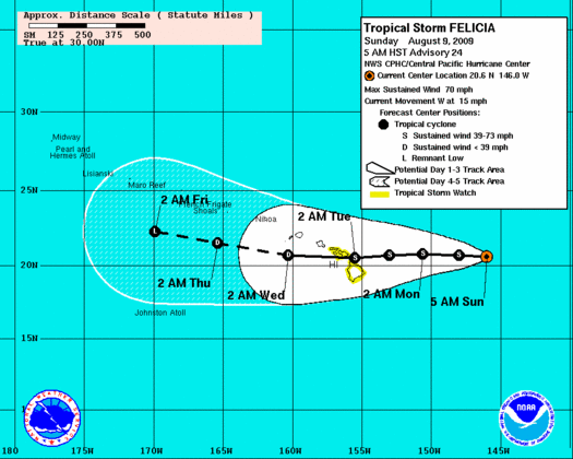
(Click to enlarge image. Image updated at 5 a.m. HST Sunday August 9, 2009. Image courtesy the National Weather Service and NOAA)
Even though Felicia was still east of the Hawaiian Islands this morning, a building swell generated by the tropical cyclone will begin to impact east facing shores of the Eastern Hawaiian Islands later today. Large surf is expected to spread to East Facing shores of all islands tonight and Monday.
8 A.M. SUMMARY INFORMATION:
LOCATION…20.9N 146.5W
MAXIMUM SUSTAINED WINDS…55 MPH
PRESENT MOVEMENT…WEST OR 285 DEGREES AT 14 MPH
MINIMUM CENTRAL PRESSURE…1001 MB
The next advisory will be issued by the Central Pacific Hurricane Center at 11 .m. HST.
(Updated at 8 a.m. HST Sunday August 9 2009 by Wendy Osher, Information provided by Forecasters POWELL/KNABB with the Central Pacific Hurricane Center)
Sponsored Content


