

Volcano Watch: A New Tephra Lab for HVO Eruption Monitoring
From US Geological Survey Hawaiian Volcano Observatory scientists and affiliates. Article written by Dr. Carolyn Parcheta and Dr. Johanne Schmith.
In addition to a new year and a new eruption, the USGS Hawaiian Volcano Observatory is ushering in a new era for processing and studying volcanic samples. The new lab will allow us to better understand physical properties of tephra.
Tephra is any type and size of rock fragment that is forcibly ejected from a volcano and travels an airborne path during an eruption. Examples include ash, bombs, scoria, and shards of volcanic glass such as Pele’s hair and Pele’s tears).
The tephra lab will help HVO geologists streamline quantitative measurements of physical characteristics such as density, size, and shape of individual tephra particles along with types of tephra. Using this information, HVO geologists can address a range of topics—from magma ascent and eruption processes to broader ash fall deposition from past explosive eruptions. It is important to get these measurements as accurately and quickly as possible during an eruption.
HVO’s new lab is unique in its ability to analyze a wide size range of samples, from one meter (3 ft) to one micron (0.00004 in). The sample processing is non-destructive and analysis is fast with each type of measurement taking only minutes, and all measurements are estimated to take 1–2 hours total. The non-destructive nature of these new instruments and methods is revolutionary and allows us to perform a full suite of analyses on the same sample (instead of different samples of the same material) for a more integrated understanding of eruptions, and allows samples to be fully preserved.
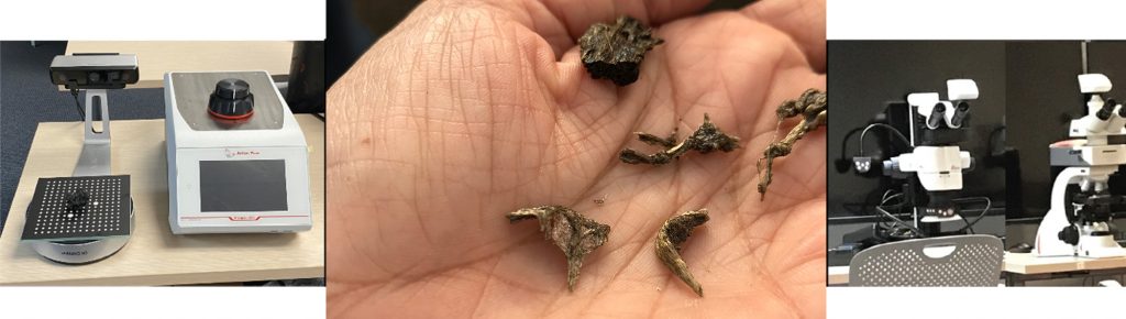
So, what are the new machines? How does a sample travel through our new lab and what can we learn from it?
First, we need to know what the sample is made of—its components. Componentry helps us understand what type of eruption we are dealing with.
For tephra samples straight from the field, HVO has two new stereoscopes that use reflected light. Looking through them, geologists can manually separate the different components that might make up the sample, such as fresh glassy lava, crystals, and small pieces of the crater wall.
Next, we measure density. For pieces of lava, measuring density helps us understand how frothy (or buoyant) the magma was when it erupted, which tells us about eruption dynamics.
We determine sample density by measuring its mass and volume. For pieces of tephra larger than 5 cm (2 in), the volume is calculated using a 3D scanner, and then the sample is weighed. Smaller grains from gravel to powdery ash sizes will be placed in a pycnometer—a machine that calculates density directly using Archemides principle of volume displacement with nitrogen gas. The pycnometers work with foams (scoria and pumice) as well as ash and helps us understand eruption dynamics.
Then, the samples will be measured for size, which informs us about how magma gets ripped apart to produce tephra from lava fountains and explosions.
Fragments larger than 3 cm (1.2 in) are sieved in the traditional (manual) way, while smaller grains will run through one of the new Camsizers—a machine that photographs each fragment and converts the image to a size measurement. The Camsizers can measure tens of thousands of fragments in as little as 5 minutes! Additionally, they use the images to measure the 2D shape of fragments using established mathematical parameters. Size information is essential for models of lava fountaining and ash fall.
A final, longer-term step (weeks to months) might occur for fragments from any sample. Those pieces will be turned into a thin section (rock epoxied to a glass plate and cut thin enough to see through it) for final analysis on a petrographic microscope. HVO has two new petrographic microscopes with different sets of lenses: one can assess bubble sizes, bubble textures, and magma-mixing textures, while the other can focus on crystals and melt inclusions within them.
HVO’s new tephra lab instruments are here, installed, and currently being calibrated. Samples from the December 20, 2020, eruption in Halema‘uma‘u at Kīlauea’s summit will be the first analyzed. The HVO tephra lab brings physical volcanology monitoring of eruptions to near-real time analysis.
Volcano Activity Updates
Kīlauea Volcano is erupting. Its USGS Volcano Alert level is at WATCH.
Lava activity is confined to Halemaʻumaʻu with lava erupting from vents on the northwest side of the crater. Wednesday afternoon (Jan. 6), the lava lake was 194 m (636 ft) deep and perched 1-2 m (1-2 yds) above its edge. Sulfur dioxide emission rate measurements made on Sunday (Jan. 3) were in the range of 3,000–6,500 t/d, this range of values was common for emissions from the pre-2018 lava lake. Summit tiltmeters recorded weak deflationary tilt since Jan. 1; at 3:00 p.m. yesterday (Jan. 6), rapid deflationary tilt started similar to the beginning of a possible deflation-inflation (DI) event. Seismicity remained elevated but stable, with steady elevated tremor and a few minor earthquakes.
Mauna Loa is not erupting and remains at Volcano Alert Level ADVISORY. This alert level does not mean that an eruption is imminent or that progression to eruption from current level of unrest is certain.
This past week, about 40 small-magnitude earthquakes were recorded beneath the upper-elevations of Mauna Loa; most of these occurred at depths of less than 8 kilometers (about 5 miles). The largest recorded earthquake was a M2.1 beneath the volcano’s northwest flank on January 4 at 6:42 p.m. HST. The earthquake activity on Mauna Loa’s northwest flank, which began on December 4, 2020, has subsided to average long-term trends. Global Positioning System (GPS) measurements recorded contraction across the summit caldera since mid-October with extension (summit inflation) resuming in the past few weeks, consistent with magma supply to the volcano’s shallow storage system. Gas concentrations and fumarole temperatures at both the summit and Sulphur Cone on the Southwest Rift Zone remain stable. Webcam views have revealed no changes to the landscape over the past week.
There were 0 events with 3 or more felt reports in the Hawaiian Islands during the past week.
HVO continues to closely monitor both Kīlauea’s ongoing eruption and Mauna Loa for any signs of increased activity.
Volcano Watch is a weekly article and activity update written by US Geological Survey Hawaiian Volcano Observatory scientists and affiliates.
Sponsored Content


