

Darby weakens to a tropical storm, will pass south of the Big Island on Saturday

Posted: (5 a.m. 7.15.22)
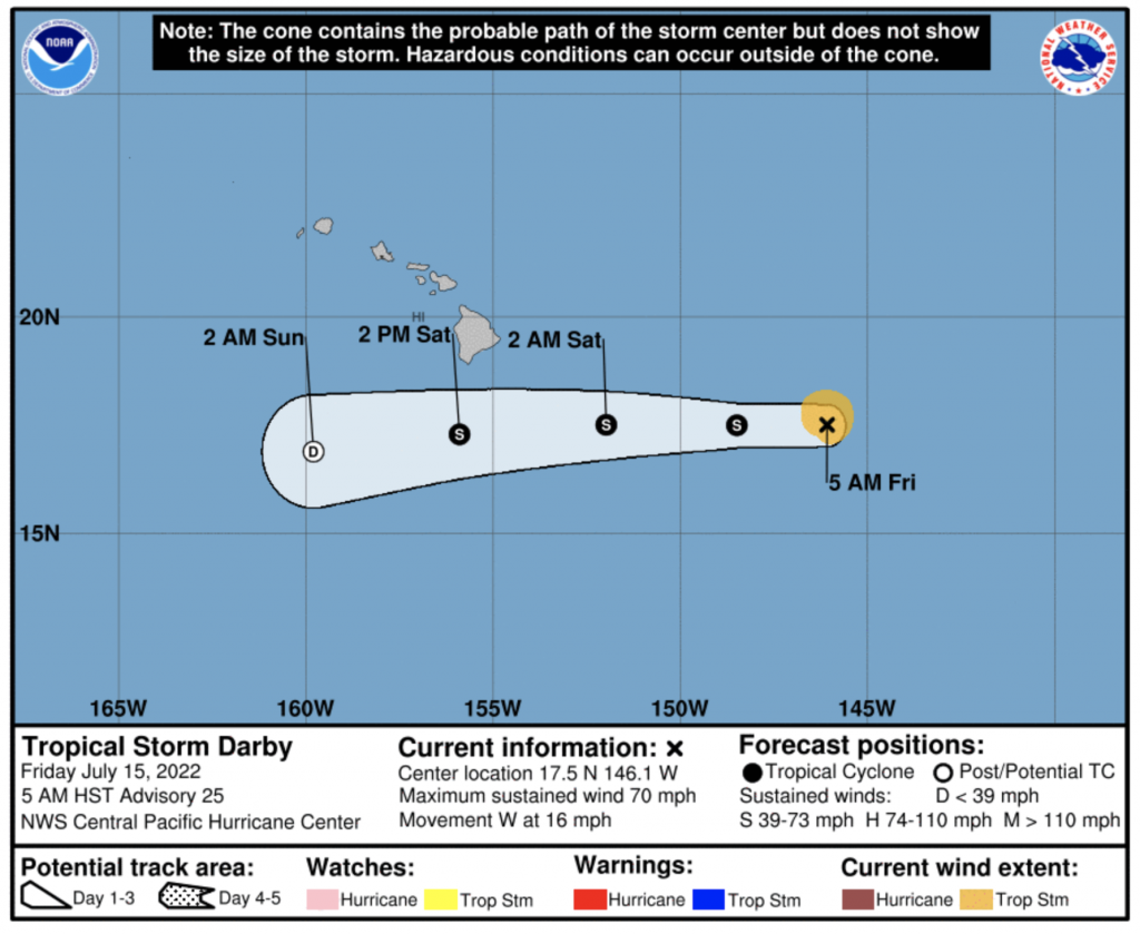
Darby has weakened overnight from a hurricane to a tropical storm, and sits well east of Hawaiʻi, according to the latest forecast issued by the Central Pacific Hurricane Center.
As of 5 a.m., the system was located about 610 miles ESE of Hilo, Hawaiʻi, and about 810 miles ESE of Honolulu.
The CPHC reports that Darby has maximum sustained winds of 70 mph, and is moving toward the west at 16 mph. Tropical-storm-force winds extend outward up to 60 miles from the center.
Forecasters say this motion is expected to continue during the next couple of days, with a slight increase in forward speed.
According to the CPHC, “The forecast track will bring the center of Darby, or its remnant low, south of the Big Island on Saturday… Weakening is forecast during the next couple days, with Darby expected to weaken into a post-tropical remnant low late Saturday or Saturday night before dissipating on Sunday.”
On the water, large swells generated by Darby are expected to affect portions of the state over the weekend. The National Weather Service says these swells are likely to produce hazardous surf and dangerous rip current conditions.
A tropical storm warning is in effect for waters including Hawaiian offshore waters beyond 40 nautical miles out to 240 nautical miles including the portion of the Papahanaumokuakea Marine National Monument east of French Frigate Shoals.
The National Weather Service issued an updated synopsis saying:
“Breezy trade winds will increase in strength with gusty winds from Saturday into Sunday as weakening Hurricane Darby passes south of the island chain. These stronger winds may approach wind advisory levels and critical fire weather thresholds in some of our leeward areas on Saturday. Shower activity will increase on Saturday and Saturday night, especially for portions of Maui and the Big Island. Windward and mountain areas will see the highest rainfall coverage each day with gusty winds and less shower activity over leeward areas. The weather pattern returns to a moderate to breezy trade wind regime from Monday onward with passing showers mainly over windward and mountain areas, favoring the overnight to early morning hours.”
The Hawai‘i Emergency Management Agency activated the State Emergency Operations Center as of 8 a.m. Thursday to monitor Darby.
The activation to Level 3, one step above normal operations, provides additional resources to plan for potential impacts and coordinate with Hawaiʻi’s counties and our other partners if they need support to cope with any consequences from the storm.
“While the National Weather Service expects Darby to weaken and pass to our south this weekend, the remains of the tropical system could still bring several inches of rain and locally strong winds to the Big Island and Maui by Saturday,” said Luke Meyers, administrator of HI-EMA on Thursday. “When you combine those potential impacts with the high surf we expect this weekend, we want to make sure we’re ready for anything, just in case.”
Darby provides a reminder that hurricane season can threaten Hawai‘i even if a storm passes well offshore, with wind, coastal waves and local flooding of roads and low-lying areas all possible.
HI-EMA reminds residents and visitors of these tips before and during heavy weather:
- Check the places where you live, work and play for potential hazards, such as blocked drainage or tree limbs that could blow through a window or roof — there’s still time to get ready.
- Top up the fuel tank and charge mobile phones, in case power fails or you need to move someplace safer.
- Make sure you have water and food supplies, necessary medicine, masks and sanitizer, battery-powered radio and other emergency supplies. HI-EMA recommends that residents are Two Weeks Ready, but even a few days’ worth makes you more prepared. Don’t forget about supplies for pets!
- There’s never a bad time to make an emergency plan with your family — and practice it.
If Darby does bring extreme conditions, remember to avoid driving into water if there’s local flooding. Flowing water can carry away a car, and Hawaiʻi’s steep valleys mean it can flow fast – turn around, don’t drown.
By coincidence, the activation of the State Emergency Operations Center is happening at the same time as a previously scheduled emergency preparedness exercise on Saturday, July 16, involving Hawai‘i amateur radio operators. If you happen to hear radio traffic about a simulated emergency on Saturday, don’t be confused. Any information related to a real emergency incident would be communicated through multiple channels, including the HI-EMA Twitter feed at @Hawaii_EMA and messages to local media.
Sponsored Content


