

Volcano Watch: Learning from the impacts of Kīlauea’s 2018 LERZ lava flows
by US Geological Survey Hawaiian Volcano Observatory scientists and affiliates. This week’s article was written by Elinor Meredith, a PhD candidate at the Earth Observatory of Singapore.
Lava flows erupted from the lower East Rift Zone of Kīlauea in 2018 and devastated lower Puna. In 2019, a team of scientists from the USGS, the Earth Observatory of Singapore, and GNS Science in New Zealand set out to document and assess the impacts to buildings and infrastructure to advance understanding of how lava flows impact the built environment.
With the permission of residents, we visited properties along the lava flow margins to meet residents, take photographs, and note the severity and types of damage to structures. In addition to field visits, we assessed more than 8,000 photographs taken by USGS scientists before, during, and after the eruption. These photographs, along with satellite imagery, make up the largest available dataset of lava flow impacts in the world.
We used our data to develop the first set of damage states for lava flows. Damage states are structure damage classifications in a scale ranging from minor damage to major damage and destruction, and they are widely used to categorize buildings damaged from other hazards such as hurricanes or earthquakes. This new set of damage states allowed us to classify all structures in the area by damage severity. Severity ranged from no visible damage, minor melting of plastic due to heat, corrosion of metal by gases, to complete burial.
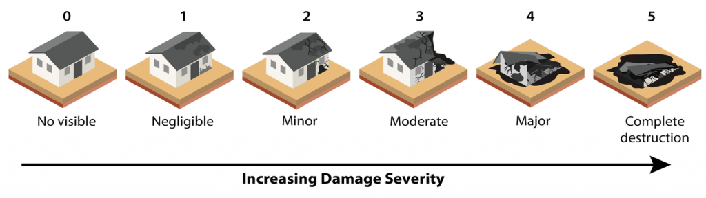
Building damage states used to classify buildings affected by Kīlauea’s 2018 lower East Rift Zone lava flows by damage severity, the first developed for lava flows. (Source: Elinor Meredith and Nguyen Thi Nam Phuong/Earth Observatory of Singapore).
Damage classification included all types of structures, including homes, water tanks and other farming or industrial buildings. Inundating 14 square miles (35.5 square km) of land, Kīlauea’s 2018 lava flows destroyed 1,839 and damaged 90 structures in total. These are the highest recorded numbers of impacted structures from a lava flow event in Hawaiʻi and one of the highest globally. Later in 2021, lava flows destroyed 2,896 buildings at La Palma, Spain, and destroyed 3,629 homes, 12 schools, and 3 health facilities at Nyiragongo volcano, Democratic Republic of Congo.
The damage severity at each structure was related to lava thickness. The data showed that increased lava flow thickness was generally related to higher damage severity, up to about 6.6 ft (2 m), after which all buildings were destroyed. However, for flow thickness less than 6.6 ft (2 m), there was a range of damage severity along the flow margins. Notably, circular and metal water tanks were resistant to these thinner flows. There were similar findings for the circular structures at Chã das Caldeiras, Cape Verde, during the 2014-2015 lava flows of Fogo volcano, where circular masonry buildings resisted destruction along the flow margins. During these lava flows, 170 structures were destroyed and 90 structures were damaged.

Aerial photograph of Kīlauea’s 2018 lower East Rift Zone lava flows that inundated 14 square miles (35.5 square km) of land, damaging and destroying structures. USGS photographs like this were used in our impact assessment of the lava flows.
We found structures were damaged mostly within the first four weeks of the 14 week-long 2018 eruption, while the main lava channels were being emplaced. Many other structures not initially impacted were destroyed by later lava flows that broke out from or overtopped the main lava channels.
We note that some homes survived in kīpukas and were classified as not damaged at all or damaged less severely. However, these homes were greatly impacted by a lack of access and disruption of utilities. We also noted impacts to homes from fissure steam and gases months after the eruption had ended.
One of our key findings is that damage was recorded up to almost 2,000 ft (600 m) away from the lava flow, likely from secondary processes such as fire spread facilitated by the dried vegetation downwind of the lava channels. This finding suggests that flammable materials on or near properties may cause damage beyond the lava flow.
This work was recently published in the Bulletin of Volcanology and it emphasizes that damage from lava flows can occur beyond the main lava flow itself, especially from later breakout lava flows and channel overflows, or from secondary fires. Findings from this research contribute to the global empirical dataset of lava impacts, and will be used to inform future lava flow damage assessments in Hawaiʻi and beyond.
Volcano Activity Updates
Kīlauea volcano is erupting. Its USGS Volcano Alert level is at WATCH are issued daily.
Over the past week, lava has continued to erupt from the western vent within Halemaʻumaʻu crater in Hawai‘i Volcanoes National Park. Sulfur dioxide emission rates remain elevated and were last measured at approximately 500 tonnes per day (t/d) on November 15. Seismicity is elevated but stable, with few earthquakes and ongoing volcanic tremor. Over the past week, summit tiltmeters recorded one deflation-inflation (DI) event.
Mauna Loa is not erupting and remains at Volcano Alert Level ADVISORY. This alert level does not mean that an eruption is imminent or that progression to an eruption from the current level of unrest is certain.
This past week, about 300 small-magnitude earthquakes were recorded below the summit and upper elevation flanks of Mauna Loa—the majority of these occurred at shallow depths less than 15 kilometers (9 miles) below sea level. Global Positioning System (GPS) measurements show continued ground deformation consistent with inflation of a magma chamber beneath the summit. Gas concentrations and fumarole temperatures at both the summit and at Sulphur Cone on the Southwest Rift Zone have remained stable over the past week. Webcams show no changes to the landscape.
There were 5 events with 3 or more felt reports in the Hawaiian Islands during the past week: a M3.9 earthquake 5 km (3 mi) SSW of Pāhala at 31 km (19 mi) depth on Nov. 16 at 6:56 p.m. HST, a M2.2 earthquake 3 km (1 mi) S of Volcano at 2 km (1 mi) depth on Nov. 13 at 10:50 p.m. HST, a M3.2 earthquake 15 km (9 mi) ENE of Honaunau-Napoopoo at 4 km (3 mi) depth on Nov. 12 at 3:10 p.m. HST, a M3.7 earthquake 18 km (11 mi) ESE of Nāʻālehu at 35 km (22 mi) depth on Nov. 12 at 10:44 a.m. HST, and a M3.6 earthquake 9 km (5 mi) E of Pāhala at 31 km (19 mi) depth on Nov. 11 at 10:29 a.m. HST.
HVO continues to closely monitor Kīlauea’s ongoing eruption and Mauna Loa for any signs of increased activity.
Volcano Watch is a weekly article and activity update written by US Geological Survey Hawaiian Volcano Observatory scientists and affiliates.
Sponsored Content


