Tsunami Advisory Ends; 1.2 Ft Rise in Sea Level Reported At Kahului Harbor 9/29/09
The Tsunami Advisory for Hawaii has ended.
Maui Mayor Charmaine Tavares expressed appreciation for readiness in Hawaii, but sadness over the effects near the quake’s epicenter off of the Samoan Islands.
“I appreciate the emergency readiness of our partnering state and federal agencies. Their efforts are as valuable as the efforts of our citizens who take steps to be prepared before a disaster happens,” Tavares said.
“While we’ve averted a natural disaster, we’re saddened by the loss of life caused by the earthquake and tsunami in Samoa and American Samoa. They, along with our Filipino community who are struggling with the destruction created by this past weekend’s Tropical Storm Ketsana in the northern part of the Philippines, need our support and prayers,” said Mayor Tavares.
This will be the final message issued for this event, unless additional data is received.
(Updated @ 7:01 p.m. HST Tuesday, September 29, 2009)
_______________
A tsunami advisory remains in effect until 7 o’clock tonight (Tuesday, September 29, 2009). The effects of the lingering Advisory have been seen in the form of sea level changes on Maui. The Maui County Civil Defense Agency reported a 1.2 foot rise in the ocean level at 3:09 p.m. That was the second highest wave activity in Hawaii associated with the 8.3 earthquake that struck off the Samoan Islands this morning. The largest wave activity in Hawaii was a 1.5 foot rise recorded at 3 p.m. on Oahu’s Haleiwa shore. A nearly one foot sea level rise was also reported at Waianae on Oahu. In addition to the sea rises, there was also a one foot drop or recession in the sea level reported at Kahului Harbor before 3 p.m. While these waves are not expected to cause any significant coastal flooding, they can result in sea level changes, strong currents and hazardous conditions. Officials with the Civil Defense Agency continue to advise the public to exercise caution. The tsunami Advisory is expected to expire at 7 p.m.
(Updated at 5:45 p.m. HST Tuesday, September 29, 2009)
________________________________
(Updated @4:20 p.m.)
The Tsunami Advisory will continue for the State of Hawaii until 7 p.m. HST. While waves are not expected to cause any significant coastal flooding, they can produce small changes of sea level at the coast and strong or unusual currents that can be a hazard to swimmers, boaters and beachgoers. The first effects were seen shortly after 1 p.m. , with a 1.2 foot rise in the ocean level reported at Kahului Harbor at 3:09 p.m. Wave action can continue for several hours after the initial wave, and the first wave is often not the largest.
Pre-recorded advisories and notifications are available 24-hours a day on the Maui County Automated Information System (AIS) by calling 986-1200.
Please refer to the telephone book yellow section for preparedness information and evacuation areas.
MEASUREMENTS OR REPORTS OF TSUNAMI WAVE ACTIVITY
GAUGE LOCATIONÂ Â Â Â Â Â Â LATÂ Â LONÂ Â Â TIMEÂ Â Â Â Â Â Â AMPLÂ Â Â Â Â Â Â Â PER
——————-Â —– ——Â —–Â —————Â —–
KAWAIHAE HAWAII     20.0N 155.8W 2:38 p 0.18M / 0.6FT 10MIN
KAPOHO HAWAII       19.5N 154.8W 2:42 p 0.14M / 0.5FT 08MIN
HONOLULU OAHU       21.3N 157.9W 3:08 p 0.16M / 0.5FT 10MIN
WAIANAE OAHU        21.4N 158.2W 2:25 p 0.26M / 0.9FT 12MIN
HALEIWA OAHU        21.6N 158.1W 3:00 p 0.46M / 1.5FT 08MIN
HILO HAWAII         19.7N 155.1W 2:12 p 0.16M / 0.5FT 18MIN
KAUMALAPAU LANAI    20.8N 157.0W 2:39 p 0.12M / 0.4FT 14MIN
MOKUOLOE OAHU       21.4N 157.8W 2:49 p 0.02M / 0.1FT 18MIN
KAHULUI MAUI        20.9N 156.5W 3:09 p 0.36M / 1.2FT 16MIN
NAWILIWILI KAUAI    22.0N 159.4W 3:08 p 0.22M / 0.7FT 08MIN
(Updated @4:20 p.m.)
____________
(Posted by Wendy Osher; Updated @ 3 p.m. HST 9/29/09)
The effects of a lingering Tsunami Advisory have been seen in the form of sea level changes on Maui. Aquatics officials reported a one foot drop in the sea level at Kahului Harbor twice over a two hour period. The drops were reported after 1 p.m. when harbor surges and ocean currents were projected to begin affecting the Hawaiian Islands. This following a large 8.3 earthquake off the Samoa Islands this morning. Officials with the Civil Defense Agency continue to advise the public to be cautions of sea level changes, strong currents and hazardous conditions. A tsunami Warning was cancelled and replaced by a Tsunami Advisory at around 10:30 this morning. The potential ocean impacts were expected to continue in the Hawaiian Islands until 4 o’clock this afternoon.
(Posted by Wendy Osher; Updated @ 3 p.m. HST 9/29/09)
________________________________
(Updated @ 10:45 a.m.)
The Pacific Tsunami Warning Center cancelled the Tsunami Watch for the state, putting an advisory in its place at around 10:23 this morning.
Based on all available data, a major tsunami is not expected to strike the State of Hawaii. However, sea level changes and strong currents may occur along the coast that could be a hazard to swimmers, boaters and beaches. All ocean recreation activities should remain cautious of tidal surge throughout the day.
High tide today will be approximately 2.0 – 2.4 feet between 1:00 p.m. to 1:45 p.m. at various points in Maui County. This will be on top of trade wind waves of 6 – 10 feet. People living in the inundation zone should be alert to ocean level changes.
The earliest impacts of possible sea level changes are estimated after 1 p.m. and can continue until 4 o’clock this afternoon.
INFORMATION: Maui County Civil Defense will continue to monitor the situation. Again, the Tsunami Watch was cancelled, and downgraded to an advisory which means sea level changes and strong currents may occur in coastal regions.
(Updated @ 10:45 a.m.)
__________________________________
(Updated @ 10:25 a.m.)
A tsunami watch for Hawaii has been canceled, but an advisory is now in effect. Based on All available data, a major tsunami is not expected to strike the state of Hawaii. However sea level changes and strong currents may occur along the coast that could be a hazard to swimmers, boaters and beaches. Therefore, a Tsunami Watch for Hawaii is cancelled, but an Advisory is in effect.
(Updated @ 10:25 a.m.)
________________________________
(Updated @ 8:15 a.m. HST)
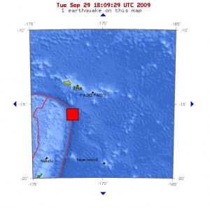
A Tsunami Watch has been issued for the state of Hawaii following an 8.3 earthquake reported at 7:48 a.m. in the Samoa Islands Region. The magnitude of the quake was upgraded from the initial 7.9 measurement released earlier this morning. The quake was centered about 139 miles southwest of Pago Pago, American Samoa.
Based on all available data, a tsunami may have been generated by the earthquake. An investigation is underway to determine if there is a threat to Hawaii. In the meantime, there has been a watch issued for the state.
If tsunami waves impact Hawaii, the estimated earliest arrival time of the first wave would be at 1:11 p.m. on Tuesday September 29th. The Pacific Warning Center broke that down into regions of impact with Nawiliwili Harbor seeing the first effects at 1:11 p.m., Hilo at 1:14 p.m., and Honolulu at 1:15 p.m. Again, this is a projection, and officials are still working to determine if a wave has been generated.
Actual arrival times may differ and the initial wave of a tsunami event may not be the largest. A tsunami is a series of waves and the time between successive waves can be five minutes to one hour.
Again, this is a Tsunami Watch. Officials are still investigating the event to determine if Hawaii will see any impacts.
We will update you with more information as it becomes available.
AN EARTHQUAKE HAS OCCURRED WITH THESE PRELIMINARY PARAMETERS
ORIGIN TIME – 0748 AM HST 29 SEP 2009
COORDINATES – 15.3 SOUTHÂ 171.0 WEST
LOCATIONÂ Â Â – SAMOA ISLANDS REGION
MAGNITUDEÂ Â – 7.9Â MOMENT
Region:Â Â Â Â Â Â Â Â Â Â Â Â Â Â Â Â Â Â Â Â Â Â Â Â Â Â Â SAMOA ISLANDS REGION
Geographic coordinates:Â Â Â Â Â Â Â Â Â Â Â 15.556S, 172.302W
Magnitude:Â Â Â Â Â Â Â Â Â Â Â Â Â Â Â Â Â Â Â Â Â Â Â 7.9 Mw
Depth:Â Â Â Â Â Â Â Â Â Â Â Â Â Â Â Â Â Â Â Â Â Â Â Â Â Â Â 85 km
Universal Time (UTC):Â Â Â Â Â Â Â Â Â Â Â Â 29 Sep 2009Â 17:48:19
Time near the Epicenter:Â Â Â Â Â Â Â Â Â 29 Sep 2009Â 06:48:19
Local standard time in your area: 29 Sep 2009Â 07:48:19
Location with respect to nearby cities:
204 km (127 miles) SSW (197 degrees) of APIA, Samoa
224 km (139 miles) SW (230 degrees) of PAGO PAGO, American Samoa
388 km (241 miles) NNE (28 degrees) of Neiafu, Tonga
2432 km (1511 miles) W (272 degrees) of PAPEETE, Tahiti, French Polynesia
EVALUATION
BASED ON ALL AVAILABLE DATA A TSUNAMI MAY HAVE BEEN GENERATED BYÂ THIS EARTHQUAKE THAT COULD BE DESTRUCTIVE ON COASTAL AREAS EVENÂ FAR FROM THE EPICENTER. AN INVESTIGATION IS UNDERWAY TO DETERMINEÂ IF THERE IS A TSUNAMI THREAT TO HAWAII.
IF TSUNAMI WAVES IMPACT HAWAII THE ESTIMATED EARLIEST ARRIVAL OFÂ THE FIRST TSUNAMI WAVE IS
0111 PM HST TUE 29 SEP 2009
LOCATIONÂ Â Â Â Â Â Â Â FORECAST POINTÂ Â Â Â COORDINATESÂ Â Â Â ARRIVAL TIME
NAWILIWILIÂ Â Â Â Â Â Â Â 22.0N 159.4WÂ Â Â 1:11 p.m. HST 29 SEP
HILOÂ Â Â Â Â Â Â Â Â Â Â Â Â Â 19.7N 155.1WÂ Â Â 1:14 p.m. HST 29 SEP
HONOLULUÂ Â Â Â Â Â Â Â Â Â 21.3N 157.9WÂ Â Â 1:15 p.m. HST 29 SEP
ACTUAL ARRIVAL TIMES MAY DIFFER AND THE INITIAL WAVE MAY NOT BE THE LARGEST. A TSUNAMI IS A SERIES OF WAVES AND THE TIME BETWEEN SUCCESSIVE WAVES CAN BE FIVE MINUTES TO ONE HOUR.
(Updated @ 8:15 a.m. HST)


