High Surf Advisory Still in Effect for East Shores

Image: Chris Archer
Alerts (as of 1:00 a.m.)
Small Craft Advisory: Through 6 a.m. Saturday.
High Surf Advisory: Until 6 a.m. Saturday for east facing shores.
Gale Warning: Through 6 p.m. Friday.
Wind Advisory: Until 6 p.m. Friday for Lāna’i & Kaho’olawe
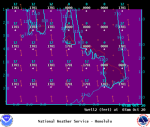
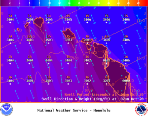
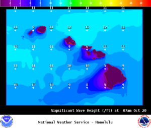
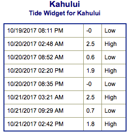
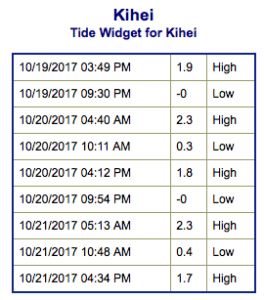
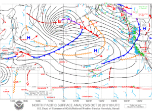
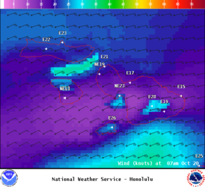
**Click directly on the images below to make them larger. Charts include: Maui County projected winds, tides, swell direction & period and expected wave heights.**
Maui Surf Forecast
North: Surf heights are expected to be chest/head high today for spots open to the trade swell. Northwest swell is down to waist high or less. New north-northwest starts building this evening.
West: Surf heights are expected to be chest/head high today for spots open to the trade swell. Spots not catching the trade swell but catching the northwest could get up to knee/waist high. Spots catching the southwest could get up to knee/waist high in the morning and dropping.
South: Surf heights are expected to be chest/head high today for spots open to the trade swell. Spots not catching the trade swell but catching the northwest could get up to knee/waist high. Spots catching the southwest could get up to knee/waist high in the morning and dropping.
Northeast trade swell for eastern exposures is forecast to hold up to chest / head high with overhead sets. A new north-northwest pulse is forecast to fill in Friday with another northwest pulse expected for Monday.
Our current south swell is forecast to slowly fade for southern exposures through Saturday.
Keep in mind, surf heights are measured on the face of the wave from trough to crest. Heights vary from beach to beach, and at the same beach, from break to break.
**Click here for your detailed Maui County weather report.**
Image; NOAA
Image; NOAA
Image; NOAA
Image; NOAA
Image; NOAA
Image; NOAA

Image; NOAA
Image; NOAA
Sponsored Content