


5 p.m.: Tropical Depression Flossie Continues to Weaken: Monday Updates

Satellite imagery of Flossie to the NE of the Hawaiian Islands. 5 p.m. 8.5.19. PC: NOAA/CPHC.
Flossie Monday Updates: http://mauinow.com/?p=308847
Maui Storm Closures/Cancellations/Notices: http://mauinow.com/?p=308555
Storm Impacts for Airports, Harbors, Highways: http://mauinow.com/?p=308580
Note: The Central Pacific Hurricane Center has concluded its official public advisories for this event. We will continue to provide weather updates of significance that impact Maui County.
(Update: 5 p.m. 8.5.19)
Flossie Degenerates to a Remnant Low, Located 90 Miles E of Hāna Maui
At 5 p.m., Post-Tropical Cyclone Flossie was located about 85 miles NNE of Hilo and 90 Miles E of Hāna, Maui (near latitude 20.8 North, longitude 154.6 West). The post-tropical cyclone is moving toward the west-northwest near 12 mph. A gradual turn toward the north-northwest is expected until dissipation on Wednesday.
Maximum sustained winds are near 35 mph with higher gusts. Flossie is expected to gradually degenerate over the next day or so and dissipate by Wednesday, according to the CPHC.
On the water, swells generated by Flossie will continue to affect the main Hawaiian Islands into Tuesday, producing hazardous surf conditions along east facing shores.
The CPHC forecast calls for moisture associated with Flossie to spread over portions of the main Hawaiian Islands during the next couple of days, bringing the potential for heavy rainfall. Total rainfall amounts of 1 to 4 inches are possible, according to the CPHC.
The National Weather Service issued an afternoon forecast update saying, “Isolated thunderstorms remain a possibility through Tuesday afternoon. Light winds, muggy conditions and showers will continue across the islands beyond midweek. Expect more showers during the afternoon hours, mainly over interior sections of the islands.”

Flossie 5-day cone forecast. 5 p.m. 8.5.19. PC: NOAA/CPHC.
(Update: 11 a.m. 8.5.19)
Tropical Depression Flossie Passing Near Hawaiʻi
The National Weather Service says showers will continue across the islands, with the eastern sides of the islands expected to have more frequent showers today as Flossie moves near the main Hawaiian Islands today and Tuesday.
“An unstable airmass over the islands could trigger some thunderstorms, and will help to enhance shower activity particularly during the afternoon hours over the interior of the islands,” according to the latest forecast update issued by the NWS.
At 11 a.m., Tropical Depression Flossie was located 105 miles ENE of Hilo, 160 miles ESE of Hāna, 190 miles ESE of Kahului, 230 miles ESE of Kaunakakai, 220 miles E of Lānaʻi City and 290 miles ESE of Honolulu (near latitude 20.2 North, longitude 153.6 West).
The depression is moving toward the WNW near 12 mph and is expected to turn toward the NW through dissipation late Tuesday night or Wednesday.
Maximum sustained winds are near 35 mph with higher gusts. Flossie is expected to become a post-tropical remnant low later today or tonight and dissipate by Wednesday, according to the Central Pacific Hurricane Center.
Flossie will continue to generate elevated surf along east facing shores today. On the water, swells generated by Flossie will continue to affect the main Hawaiian Islands into tomorrow morning.
On land, “moisture associated with Flossie will spread over portions of the main Hawaiian Islands during the next couple of days, bringing the potential for heavy rainfall.” The CPHC says total rainfall amounts of 1 to 4 inches are expected, with localized higher amounts possible.

5-day cone forecast. 11 a.m. 8.5.19. PC: NOAA/CPHC.
(Update: 5 a.m. 8.5.19)
Flossie Remains a Tropical Depression as it Nears Hawaii
Flossie is expected to become a post-tropical remnant low later today, and dissipate late Tuesday or Tuesday night, according to the Central Pacific Hurricane Center. The system will move near the main Hawaiian Islands later today through Tuesday.
At 5 a.m., Tropical Depression Flossie was located about 155 miles E of Hilo and 225 mile ESE of Hana, Maui (near latitude 19.7 North, longitude 152.7 West).
The depression is moving toward the west-northwest near 15 mph with maximum sustained winds are near 35 mph. Little change in strength is forecast during the next couple of days, according to the CPHC.
On the water, swells generated by Flossie “will continue to affect portions of the main Hawaiian Islands during the next day or two, producing dangerous surf conditions along east facing shores.”
On land, “moisture associated with Flossie will spread over portions of the main Hawaiian Islands during the next couple of days, bringing the potential for heavy rainfall.” The CPHC says “total rainfall amounts of 1 to 4 inches are expected, with localized higher amounts possible.”
The National Weather Service issued a morning forecast update saying:
“Wet weather remains in the forecast for all the Hawaiian Islands through Wednesday. Tropical Depression Flossie will weaken as it passes just north of the state spreading rain showers to all of the islands. The main threats with Flossie are from high surf, periods of heavy rain, and thunderstorms. Instability caused by an upper level trough just northwest of the state will keep the airmass a bit unstable enhancing showers and thunderstorm activity over the western islands. A moderate trade wind weather pattern will return on Wednesday with drying trends for most islands lasting into next weekend.”

Flossie 5 Day cone forecast. 5 a.m. 8.5.19. PC: NOAA/CPHC
(Update: 11 p.m. 8.4.19)
Tropical Depression Flossie Continues to Weaken on its Approach to Hawaii
The weakening Flossie has been downgraded to a Tropical Depression and will move near the main Hawaiian Islands Monday through Tuesday, according to the latest forecast from the Central Pacific Hurricane Center.
“Weakening is forecast during the next couple days, with Flossie becoming a post-tropical remnant low Monday or Monday night, and dissipating on Tuesday,” according to the CPHC.
The National Weather Service issued a forecast update as well saying, “wet weather remains in the forecast for all the Hawaiian Islands from Monday into Wednesday as Flossie’s passing will spread rain showers to all islands.”
According to the NWS, “The main threats with Flossie are from high surf, periods of heavy rain and thunderstorms. Instability caused by an upper level trough just NW of the state will keep the airmass a bit unstable allowing for local thunderstorm activity.”
At 11 p.m., Tropical Depression Flossie was located about 400 miles E of Hilo and 320 miles ESE of Hāna, Maui (near latitude 19.4 North, longitude 151.3 West).
The depression is moving toward the WNW near 15 mph, with a turn toward the NW and a slight decrease in forward speed expected Monday through Tuesday, according to the CPHC.
Maximum sustained winds are near 35 mph with higher gusts.
On the water, the CPHC says “swells generated by Flossie will continue to affect portions of the main Hawaiian Islands during the next day or two, producing dangerous surf conditions along east and southeast facing shores.”
On land, the CPHC says, “moisture associated with Flossie will spread over portions of the main Hawaiian Islands on Monday, bringing the potential for heavy rainfall. Total rainfall amounts of 1 to 4 inches are expected, with localized higher amounts.”
The NWS forecasts a trade wind weather pattern to make a return from late Wednesday into next weekend.
Meantime, both Erick to the West and Gil to the East have weakened into post-tropical remnant lows and are not considered a threat to our island weather.

Flossie 5-day forecast cone. 11 p.m. 8.4.19. PC: NOAA/CPHC
-

- Flossie. 11 p.m. 8.4.19. PC: NOAA/CPHC,
-

- Flossie. 11 p.m. 8.4.19. PC: NOAA/CPHC,
-

- Flossie. 11 p.m. 8.4.19. PC: NOAA/CPHC,
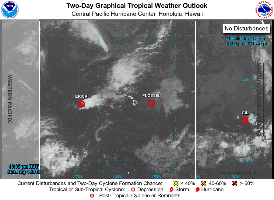
Erick, Flossie and Gil. 11 p.m. 8.4.19. PC: NOAA/CPHC,
Sponsored Content


