

Volcano Watch: Kīlauea magma intrusion a textbook example of dike propagation
by US Geological Survey Hawaiian Volcano Observatory scientists and affiliates. Today’s article is by HVO geophysicist Ingrid Johanson.
From Jan. 31 to Feb. 3, 2024, a magma intrusion into Kīlauea’s flank, southwest of the summit caldera, was the focus of attention at the USGS Hawaiian Volcano Observatory.
Hundreds of earthquakes announced the influx of new magma. The intensity of the seismic activity was similar to what has preceded recent summit eruptions at Kīlauea, prompting HVO staff to raise Kīlauea’s Alert Level/Aviation Color Code to WATCH/ORANGE at 4:41 a.m. HST on Jan. 31. After earthquake activity receded on Feb. 3, 2024, the alert level was returned to ADVISORY/YELLOW.
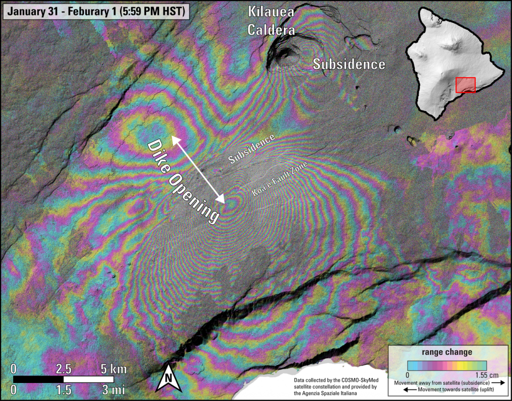
In addition to the high number of earthquakes, high rates of deformation were also recorded during the intrusion. Typically, HVO monitors near real-time changes in deformation using a network of tiltmeters and continuous GPS stations. For this intrusion, lucky timing of image acquisitions from the Italian Space Agency’s COSMO-SkyMed satellite (CSM), gave us a special 1-day image pair from 6 p.m. HST on Jan. 31 through 6 p.m. HST on Feb. 1. Differences between the image pair show how the ground deformed over that 24-hour period, in what is called an interferogram.
This interferogram confirmed that the recent intrusion was larger than previous ones in October 2023 or August 2021. The pattern of deformation in the interferogram had a “classic” dike-opening intrusion pattern; what we would expect from magma opening a rectangular, vertically oriented space in the existing rock.
The shape of the opening magma body affects what the pattern of ground deformation will be. For example, a spherical magma chamber will cause outward motion and uplift when it inflates. The deformation pattern from dike-opening is complicated and consists of outward and upward motion away from the broad sides of the dike. At the same time, the ground just outside the dike tip is pulled towards the dike and the ground just above is pulled downwards. This is not that different from opening a bag of chips by pulling on the sides. As you’re pulling the sides outwards, the top and side edge of the packet get drawn down and inwards.
Seeing a dike-opening pattern in an interferogram is made even more complicated by how interferograms record ground motion. The fringes (one rainbow cycle) in an interferogram represent motion between the ground and satellite (range change) in the “look direction” of the radar instrument. For CSM, one fringe equals 1.5 cm (0.6 in) of range change. The satellites we use do not look straight down at the ground, instead they send the radar pulses out at an angle (CSM’s look angle is about 40 degrees off-vertical). This means that both horizontal and vertical motion get mixed together to create “range change.”
In the Jan. 31 to Feb. 1 interferogram, outward and upward motion to the southeast add together to create dense fringes. However, outward motion and upward motion to the northwest cancel each other out somewhat and result in fewer fringes. This is because motion to the northwest increases range change, but upward motion decreases it.
If one looks carefully, the fringes to the southeast progress from pink to yellow to blue, as you proceed away from the central “bullseye.” The fringes on the northwest side progress from blue to yellow to pink away from the bullseye in that area. This means that range change is increasing in that quadrant; because there was so much horizontal motion away from the satellite, it completely counteracted the uplift to create lengthening range change.
In between the colorful lobes to the southeast and northwest, there is an area of dense and discontinuous fringes in the middle. This is the portion of ground that subsided above the dike. It’s also an area with lots of surface cracks, which is why there is sometimes a sharp offset in the fringe patterns.
To a geophysicist, this is a beautiful interferogram. Not just because of the interesting patterns of the rainbow fringes, but because it beautifully illustrates the unique way that interferograms capture ground motion via range change. It’s also a textbook illustration of deformation from a dike intrusion, one of the fundamental processes for magma migration at volcanoes around the world.
Volcano Activity Updates
Kīlauea is not erupting. Its USGS Volcano Alert level is ADVISORY.
Disbursed seismicity at Kīlauea’s summit and along the Koa‘e fault system southwest of the caldera continues following an intrusion of magma into the area that occurred Jan. 31 to Feb. 1, 2024; on average, earthquake counts remain below 10 per day. Tiltmeters near Sand Hill and Uēkahuna bluff have recorded mild inflationary trends over the past week. Periods of increased earthquake activity and rates of ground deformation can be expected to continue in this region. No unusual activity has been noted along the rift zones.
Mauna Loa is not erupting. Its USGS Volcano Alert Level is at NORMAL.
Webcams show no signs of activity on Mauna Loa. Summit seismicity has remained at low levels over the past month. Ground deformation indicates continuing slow inflation as magma replenishes the reservoir system following the 2022 eruption. SO2 emission rates are at background levels.
One earthquake was reported felt in the Hawaiian Islands during the past week: a M3.1 earthquake 2 km (1 mi) WSW of Pāhala at 34 km (21 mi) depth on Feb. 27 at 11:32 p.m. HST.
HVO continues to closely monitor Kīlauea and Mauna Loa.
Visit HVO’s website for past Volcano Watch articles, Kīlauea and Mauna Loa updates, volcano photos, maps and recent earthquake information. Email questions to askHVO@usgs.gov.
Sponsored Content


