

Heightened unrest at summit region of Kīlauea Volcano

The Hawaiian Volcano Observatory issued an information statement on Thursday night saying the summit region of Kīlauea is currently experiencing heightened unrest, but no eruptive activity.
Both seismicity and ground deformation increased sharply in the past week with most seismicity focused along Chain of Craters Road from Luamanu Crater to Pauahi Crater, according to the HVO. “This activity is reflective of increasing pressurization in the magmatic system underlying the Kīlauea summit region,” scientists said.
HVO scientists report that current conditions are not indicative of an imminent eruption, but this could change rapidly. Prior eruptions in the summit region have occurred with very little warning, according to the agency.
The Kīlauea volcano alert level and aviation color code remain at ADVISORY/YELLOW, but this could change quickly if conditions warrant.
Kīlauea webcam images are available at the following link: https://www.usgs.gov/volcanoes/kilauea/webcams
1,600 earthquakes in six days
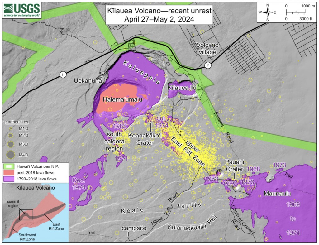
According to the HVO, more than 1,600 earthquakes have occurred in the six days since April 27. These were initially concentrated beneath the upper East Rift Zone along Chain of Craters Road between Puhimau Crater and Hilina Pali Road but have since expanded northwestward to Luamanu Crater and Keanakākoʻi Crater, and southeastward to Pauahi Crater.
Approximately 300 more earthquakes have been located south of Halemaʻumaʻu within the outer boundaries of Kaluapele (Kīlauea caldera).
Most events have been smaller than magnutude-2 and located at depths of 2–4 km (1–2 miles) beneath the surface. The largest event was a magnitude-3.3 that occurred late on the evening of April 28. A magnitude-3.1 also occurred at 4:07 p.m. HST on May 2.
Though separated by days, both earthquakes took place close together beneath the region northeast of the intersection of the Chain of Craters and Hilina Pali roads.
Periods of low-frequency activity typical of magma movement have also been detected intermittently over the past week beneath Halemaʻumaʻu and extending to the south part of Kaluapele during the unrest, according to the HVO.
Patterns of ground motion and tilt show that the magma bodies below the southern end of Kaluapele (referred to as the south caldera reservoir) and below Halemaʻumaʻu are inflating. These bodies are long-term features of Kīlauea’s summit magma plumbing system. They both began to inflate in tandem around October 2023 and continued to inflate through late January.
Stored magma drained from these chambers and fed the intrusion into the Southwest Rift Zone in late January–early February 2024.
Deformation levels indicate that the south caldera reservoir has regained the magma that it lost during the intrusion. Current pressurization levels are now even with pre-intrusion levels after two months of magmatic recharge, according to the statement.
The Sand Hill tiltmeter (SDH) is more sensitive to the deeper south caldera magma reservoir and has shown steady inflationary tilt since early February, the HVO reports. The Uēkahuna tiltmeter (UWE) is more sensitive to the Halemaʻumaʻu reservoir, which was the source for recent summit eruptions. UWE has been slower to accumulate tilt change, implying that the south caldera reservoir continues to be the focus of inflation.
HVO scientists interpret recent activity
The magma storage system beneath Kīlauea has recharged following the intrusion that occurred southwest of the summit in late January–early February of this year. Recent earthquakes occurring in the upper East Rift Zone reflect the higher level of pressurization, according to the HVO.
Pit craters and lava flows in the upper East Rift Zone of Kīlauea are evidence of a long history of magma moving along this rift zone pathway. Intrusions of new magma into this region have been monitored numerous times in the past decades, with sparse eruptions.
During the past 60 years, there have been approximately 50 intrusions and five eruptions in the upper East Rift Zone region.
Most recently, in November 1979, a brief one-day eruption occurred in and near Pauahi Crater; it was preceded by two months of increased earthquake activity, along with inflation at the summit region.
Several other eruptions took place in this area in the early 1970s, lasting from one day to about a month.
Eruptions in the upper East Rift Zone have typically occurred near the southeast margin of Kaluapele or where the upper East Rift Zone meets the middle East Rift Zone, near Pauahi Crater, the HVO reports.
What to expect
It is not possible to forecast an exact outcome of this activity, the HVO says. “Based on the pattern of past activity in the upper East Rift Zone, the current activity is much more likely to result in an intrusion rather than an eruption. However, future changes in the location of unrest—and the potential for eruption—could unfold quickly (in days to hours),” according to HVO scientists.
The HVO reports there are several possible scenarios that could play out in the coming days to weeks:
- Magma continues to accumulate in reservoirs beneath Kīlauea’s summit. Earthquakes and ground deformation continue at varying rates, but no eruption occurs.
- Magma continues to accumulate in reservoirs beneath Kīlauea’s summit, resulting in magma moving into a new area via a dike intrusion. This could occur to the southeast, in the region of elevated earthquake activity, or return to the southwest (similar to what occurred during late January–early February of 2024). In this scenario, we would expect to see accelerated rates of ground deformation and earthquakes in the direction of the intrusion as it occurs, along with summit deflation.
- Magma continues to accumulate in the Kīlauea summit region, with an eventual eruption inside the caldera, similar to recent eruptions at Halema‘uma‘u. In this scenario, we would expect to see signs of the magma reservoir beneath Halema‘uma‘u rapidly pressurizing prior to accelerated rates of ground deformation and earthquakes beneath the caldera 1–2 hours before lava reaches the surface.
- Magma continues to accumulate beneath Kīlauea’s summit region, with an eventual eruption outside of the caldera in the upper portions of one of the rift zones. In this scenario, we would expect to see earthquake locations migrating away from the caldera, followed by accelerating rates of ground deformation and earthquakes 1–2 hours before lava reaches the surface.
Sponsored Content


