

Iselle Brings “Triple Threat” of Impacts Over Next 24 Hours
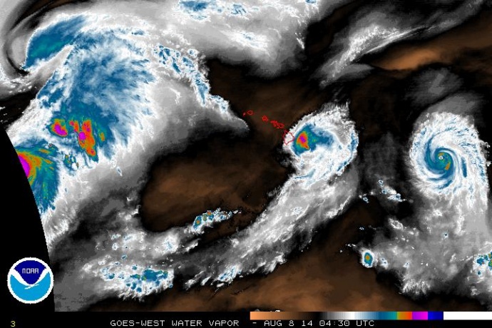
Satellite imagery of Iselle at 6:30 p.m. HST, Thursday, Aug. 7, 2014. Image courtesy CPHC/NOAA/NWS.
By Wendy Osher
(Update: 7:30 p.m. 8/7/2014)
Hurricane Iselle is now making its way over the Big Island of Hawaiʻi as the western edge of the system brings strong winds and rains to the island.
“As the center rolls in, we’ll get the burst of the strongest winds as that northeastern side comes in to the Big Island and eventually progresses westward and south of the remaining Hawaiian islands,” said Mike Cantin with the National Weather Service in a press conference at 6:30 p.m.
“We’re beginning to see the effects now with some power outages, downed trees and some rain picking up. We expect that to intensify as we go into the evening and overnight hours and the system progresses westward,” said Cantin.
“We do expect it to become a tropical storm and weaken fairly quickly as it moves westward because of increasing wind shear; but we still do anticipate impacts of winds from 35 to 45 mph, or maybe upwards of 55 to 65 mph for portions of Maui County, Oʻahu, and Kauaʻi,” said Cantin.
Cantin said the wind is strong enough to do minor to moderate damage to structures, especially older homes and roofs, to power poles, power lines, trees and tree branches.
“The entire state remains under the gun, although the Big Island right now is the main target as we go through the next four to eight hours as the system rolls through,” said Cantin.
“But, (there are) no significant changes to our forecast. Still expecting 4 to 8 inches or so of rainfall for all areas, especially windward, but potentially up to a foot of rain — 12 plus inches in some locations as well; and then surf building 15 to 25 feet over the eastern shores of the Big Island. Elsewhere across the rest of the state, about 10 to 15 feet on both the east and south-facing shores of the smaller islands.”
Cantin said that dangers on land with strong winds and flooding potential, and on the sea with high waves and storm surge along the coast make the system a threat. “On all facets the storm is a triple threat of tropical cyclone impacts over the next 24 hours.”
Authorities with the National Weather Service say now is not the time to be running out to get supplies. The agency advises the public to hunker down and stay in a safe location as the storm approaches.
In earlier reports, authorities with the Central Pacific Hurricane Center said the onset on Maui was projected to be between 9 and 10 p.m. tonight (8/7/2014). A Maui specific update was provided in a mid-day press conference conducted by Mayor Arakawa.
Maui County Forecast Update from the National Weather Service issued at 5:46 p.m. 8/7/2014:
PRECAUTIONARY/PREPAREDNESS ACTIONS…LOOSE OBJECTS SUCH AS LAWN FURNITURE…GARBAGE CANS…AND OTHER
ITEMS SHOULD BE SECURED OR STORED INDOORS. HAVE SUPPLIES ON HAND
AND BE READY FOR POWER OUTAGES. EVACUATE IF ORDERED BY LOCAL
OFFICIALS.TROPICAL STORMS CAN BRING VERY HEAVY RAIN LEADING TO FLASH
FLOODING. PEOPLE NEAR STREAMS…RIVERS…AND LOW-LYING FLOOD
PRONE AREAS ARE URGED TO BE ESPECIALLY ALERT TO FLASH FLOODING.&&..WINDS…
BASED ON THE LATEST FORECAST TRACK…WINDS OVER 40 MPH ARE
EXPECTED TO OVERSPREAD THE AREA TONIGHT AND CONTINUE THROUGH LATE
FRIDAY MORNING. IN SOME AREAS…WINDS WILL BE AS HIGH AS 45 TO
55 MPH WITH GUSTS TO 65 MPH.GUSTS WILL BE STRONGEST OVER MOUNTAINOUS TERRAIN…THROUGH
PASSES…AND WHERE WINDS BLOW DOWNSLOPE. WINDS AFFECTING THE
UPPER FLOORS OF HIGH RISE BUILDINGS WILL BE SIGNIFICANTLY
STRONGER THAN THOSE NEAR GROUND LEVEL.HOMES MAY HAVE DAMAGE TO SHINGLES…SIDING…GUTTERS AND
WINDOWS…ESPECIALLY IF THESE ITEMS ARE NOT PROPERLY SECURED.
LOOSE OUTDOOR ITEMS WILL BECOME AIRBORNE…CAUSING ADDITIONAL
DAMAGE AND POSSIBLE INJURY.
SOME POWER LINES WILL BE KNOCKED DOWN BY FALLING TREES…
RESULTING IN SCATTERED POWER OUTAGES. MANY LARGE BRANCHES OF
TREES WILL BE SNAPPED…AND A FEW TREES WILL BE UPROOTED.
..STORM SURGE AND STORM TIDE…
SURF WILL STEADILY INCREASE TO HAZARDOUS LEVELS OF 18 FEET ALONG
THE EXPOSED WINDWARD COASTS OVERNIGHT. SOME SOUTH FACING SHORES
FOR HANA EARLIER TODAY WAS AT 142 PM AT 2.7 FEET AND WILL BE AT
218 PM AT 2.9 FEET ON FRIDAY. THE HIGH SURF AND HIGH TIDE
LOW LYING AREAS...INLAND FLOODING…
A FLASH FLOOD WATCH IS IN EFFECT FOR THE ENTIRE AREA. HEAVY
RAINFALL OF AROUND 5 TO 8 INCHES IS EXPECTED WITH ISOLATED
RAINFALL TOTALS OF 12 INCHES. THESE HEAVY RAINS COULD LEAD TO
LIFE THREATENING FLASH FLOODS.
Sponsored Content


