

Iselle Impacts Begin, Maui Onset Between 9 and 10 p.m.
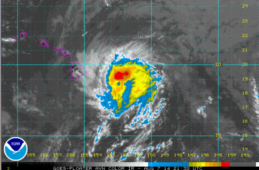
Mid-day imagery as Iselle begins impacting Hawaiʻi Island. Image courtesy CPHC/NOAA/NWS.
By Wendy Osher
Current Situation:
Hurricane Iselle is currently a minimal hurricane at this time. The system is lcoated 190 miles ESE of Hilo, Hawaiʻi and was moving WNW at 16 mph with maximum sustained winds of 75 mph.
Authorities with the Central Pacific Hurricane Center say that although Iselle is predicted to slowly weaken it is expected to strike the Big Island of Hawaiʻi as a high-end tropical storm or a low-end hurricane.
Wind gusts of 55 mph have already been recorded on the Big Island of Hawaiʻi in the Mauna Kea area. The onset for Maui is projected to be between 9 and 10 p.m. according to the Central Pacific Hurricane Center.
A Maui specific update was provided in a mid-day press conference conducted by Mayor Arakawa.
The outer rain bands of the system are now reaching the eastern side of Big Island of Hawaiʻi, with winds starting to pickup from the NE ahead of the storm.
Forecast Uncertainty:
The Central Pacific Hurricane Center says Iselle is still a hurricane, and is expected to be at or near hurricane strength as it makes landfall on the Big Island. It will continue on a WNW path toward the state.
There is still a hurricane warning in effect for Hawaiʻi County; a tropical storm warning in effect for remainder of the state; and a flood watch in effect for the state.
Impact, Rain and Wind:
There is a potential for heavy rain through Friday with 4 to 8 inches expected and 12 inches of locally higher rainfall in some locations.
Strong winds are possible through Friday with sustained winds of 60 to 70 mph, and gusts of 85 mph expected on the Big Island. Elsewhere, winds will be 40-50 mph or higher, with locally higher gusts.
High surf is already having impacts on eastern side of Big Island. Surf is forecast to be in the 15 to 25 foot range on Hawaiʻi Island; 12-18 on east shores of Maui, 10-15 feet on the south facing shores of Maui on Friday; 10-15 feet favoring the east-facing shores of Oʻahu beginning today, and affecting the south-facing shores on Friday; and 10-15 feet favoring the east facing shores of Kauaʻi tonight and along the south facing shores of the island on Friday.
Timing Frame:
Wind gusts of 55 mph have already been recorded on the Big Island of Hawaiʻi. Gusts so far include: 50 mph in Kamuela/Waimea; 45 mph in the Volcano area; 35 mph in Hilo; 35 mph at the Kona Airport; and 55 mph at Mauna Kea.
In Maui county the onset of the storm is expected between 9 and 10 p.m. tonight (Thursday, Aug. 7); on Oʻahu, the onset is expected between 6 and 7 a.m. on Friday, Aug. 8; and on Kauaʻi, the onset is expected between 4 and 5 p.m. on Friday, Aug. 8.
Main Points:
- Heavy rainfall is likely for much of the area, with flash flooding a distinct possibility.
- Strong winds are expected, especially for the Big Island of Hawaiʻi.
- Rain bands with gusty winds are expected to reach the Big Island of Hawaiʻi this afternoon; reach Maui County this evening; and Friday for the western islands.
- Review preparedness plans and supplies. Preparations need to be completed soon, if not already.
- As strong winds develop, power outages are likely.
- Consideration should be made regarding boarding windows. Flying debris is possible, especially for the eastern portion of the Big Island of Hawaiʻi.
Sponsored Content


