

Iselle Update: Impacts Projected for Maui
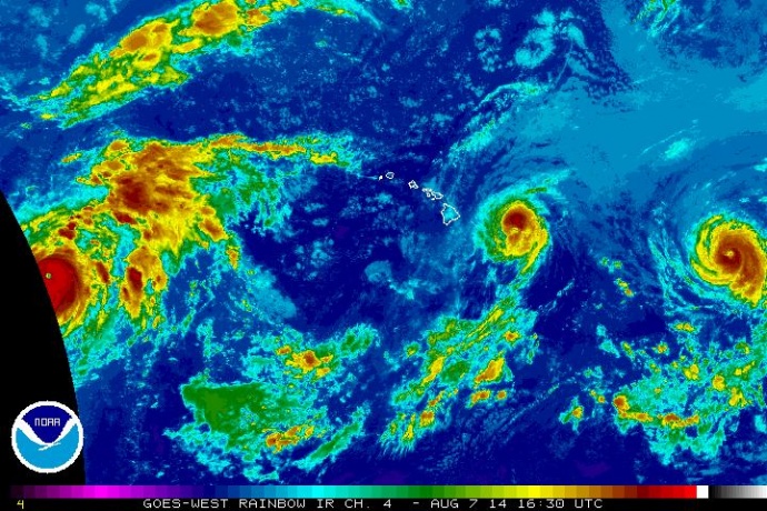
Satellite imagery of Iselle at 6:30 a.m. HST, Thursday, Aug. 7, 2014. Image courtesy CPHC/NOAA/NWS.
By Wendy Osher
(Update: 6:35 a.m. Thursday, 8/7/2014)
At 5 a.m. HST on Thursday, Aug. 7, 2014, Iselle was located: 300 miles ESE of Hilo, Hawaiʻi; 360 miles ESE of Kailua-Kona, Hawaiʻi; 335 miles E of South Point, Hawaiʻi; 410 miles ESE of Kahului, Maui; 465 miles ESE of Kaunakakai, Molokaʻi; 440 miles ESE of Lānaʻi City, Lānaʻi; 510 miles ESE of Honolulu, Oʻahu; 610 miles ESE of Līhue, Kauaʻi; and 660 miles ESE of Niʻihau, according to the Central Pacific Hurricane Center.
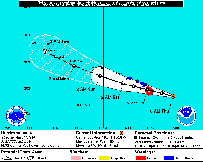
Iselle 5-day track 5 a.m. HST Thursday, Aug. 7, 2014. Image courtesy CPHC/NOAA/NWS.
The system was moving WNW at 17 mph with maximum sustained winds near 80 mph.
Forecasters with the National Weather Service say Iselle is still on track to make landfall on Hawaiʻi Island as a hurricane, then weaken slightly as it passes over the island later today. The system is expected to be a tropical storm when it reaches Maui County tonight.
The Central Pacific Hurricane Center says the onset of tropical storm conditions are expected over Maui County tonight, with very large damaging surf expected along mainly east and south shores starting late tonight.
WINDS: Based on the latest forecast track, winds of 40 mph are expected to begin spreading over Hawaiʻi Island late this afternoon and early this evening. Winds will be as high as 60 to 70 mph with 85 mph gusts on Hawaiʻi Island. Here on Maui, 40 mph winds will begin spreading over the county tonight, and continue through late Friday morning. In some areas, NWS forecasters say winds will be as high as 45 to 55 mph with 65 mph gusts.
The Central Pacific Hurricane Center advises that wind gusts will be strongest over mountainous terrain, through passes, and where winds blow down-slope. The agency advises that homes may sustain damage to shingles, siding, gutters and windows, especially if the items are not properly secured. Any loose items that are outdoor, should be tied down in advance of the storm impacts to prevent them from becoming airborne and causing additional damage or injury.
The public is advised to be aware of power lines that can be knocked down by falling trees and branches. The severe weather may result in scattered power outages.
STORM SURGE AND TIDE: The Central Pacific Hurricane Center is forecasting a steady rise in surf along exposed windward coasts today, with surf reaching hazardous levels later today. The forecast calls for a rapid increase to near 15 feet today. The “astronomical high tide” for Hāna will be 2.7 feet at 1:42 p.m. on Thursday, Aug. 7; and 2.9 feet at 2:18 p.m. on Friday, Aug. 8. The agency says the high surf and high tide combination will bring the potential for coastal flooding along low-lying areas. On Hawaiʻi Island, the CPHC says the threat of coastal flooding and property damage will be greatest on the windward side of the island.
RAIN/INLAND FLOODING: Rainfall amounts are projected to be around 5 to 8 inches, with isolated locations receiving as much as 12 inches. The Central Pacific Hurricane Center advises that the impending rains could lead to life-threatening flash floods.
PRECAUTIONARY MEASURES: Authorities say it is vital that the public not focus on the exact forecast track of the storm. Movement, direction, and speed are only estimates, and even small errors in the forecast track can mean major differences in where the worst conditions will occur. The CPHC says damaging effects can extend far from the center of the storm.
The CPHC issued the following tips:
Now is the time to prepare. Do not wait until it is too late. Stay calm and keep informed. Closely monitor radio or other local news outlets for official information on the storm. Listen for warnings or changes to the forecast.
Loose objects such as lawn furniture, garbage cans and other items should be secured or stored indoors. Have supplies on hand and be ready for power outages.
Be ready to evacuate if necessary. Heed the advice of local officials and comply with any orders that are issued. Persons living near the shore should be prepared to evacuate quickly should building surf threaten.
HURRICANE JULIO:
Another hurricane, Julio was last located 1230 miles ESE of Hilo and is projected to impact the state on Sunday.
As of 5 a.m. on 8/7/2014, the CPHC said Julio was located:
1230 miles ESE of Hilo
1290 miles ESE of Kailua-Kona
1265 miles E of South Point
1325 miles ESE of Kahului, Maui
1380 miles ESE of Kaunakakaʻi, Molokaʻi
1360 miles ESE of Lānaʻi City
1425 miles ESE of Honolulu
1520 miles ESE of Līhue, Kauaʻi
1575 miles ESE of Niʻihau
1865 miles SW of Las Vegas NV
Sponsored Content


