

UPDATE: 11 p.m. 10/15/14, Ana Forecast Discussion
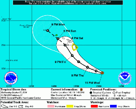
5-day forecast track for Tropical Storm Ana as of 11 p.m. on Wednesday, Oct. 15, 2014. Image courtesy NOAA/NWS/Central Pacific Hurricane Center.
By Meteorologist Malika Dudley
The latest update on Tropical Storm ANA was just released by the Central Pacific Hurricane Center. ANA has weakened slightly but the National Weather Service indicates even if intensification does not occur, impacts could still be quite severe.
Summary of Alerts:
HURRICANE WARNING – All Hawaiian Offshore Waters
TROPICAL STORM WATCH – Hawaiʻi County
FLASH FLOOD WATCH – Hawaiʻi County
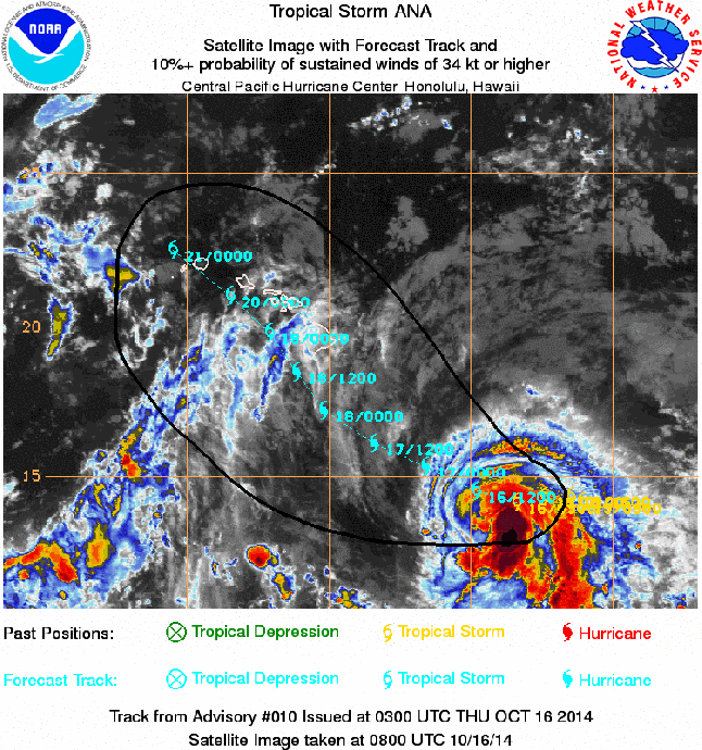
Satellite imagery, 11:00 p.m. HST, Wednesday, Oct. 15, 2014, courtesy NOAA/NWS.
Current Situation:
Tropical Storm with 60 mph Maximum Sustained Winds, Gusting to 70 mph
Tropical storm force winds extend 60 miles from the center
Moving W at 10 mph
Tropical Storm Ana was last located near 14.1 N and 149.3 W, about 540 miles SE of Hilo, Hawaiʻi; 665 miles SE of Kahului, Maui; 710 miles SE of Kaunakakai, Molokaʻi; 680 miles SE of Lānaʻi City; and 755 miles SE of Honolulu, Oʻahu on Wednesday, Oct. 15, 2014 at 11 p.m.
ANA is looking more and more ragged as vertical wind shear continues to affect the storm. Because of this it’s hard to pinpoint exactly where the center of the system is. The Central Pacific Hurricane Center is indicating that the intensity forecast is quite tricky with this storm. Sea surface temperatures are more than sufficient to fuel ANA and vertical wind shear is expected to decrease so further intensification is the likely result of that. However, some models are still indicating that ANA will not become a hurricane and the way the storm is starting to rip apart looks to support that outcome. The current intensity forecast takes all models into account.
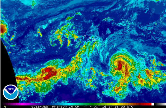
Satellite imagery, 10:52 p.m. HST, Wednesday, Oct. 15, 2014, courtesy NOAA/NWS.
Forecast & Uncertainty:
The current track has not changed much with ANA passing just south and west of the Island of Hawaiʻi Friday night and Saturday, passing Maui County Saturday into Sunday and nearing Oʻahu and Kauaʻi over the weekend and into Monday.
Remember, these systems are notoriously difficult to predict and the center of the storm has a 66% chance of landing anywhere within the cone of uncertainty. The margin of error going out 48 hours is still a whopping 80 miles. Even small shifts in the track can mean major differences in where the worst conditions will occur. Damaging effects can extend far from the center so it’s important that residents prepare just in case.
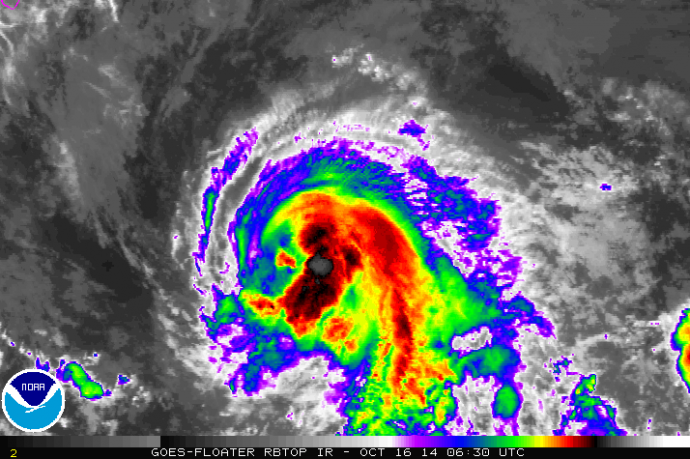
Satellite imagery, 10:52 p.m. HST, Wednesday, Oct. 15, 2014, courtesy NOAA/NWS.
Potential Impacts (if the track holds):
Heavy rain may reach the Big Island late Friday potentially causing dangerous flash flooding and mud slides.
Large dangerous surf conditions are expected to begin impacting the eastern end of the Hawaiian islands late Thursday.
Big Island – Winds of 55 to 65mph, gusting to 80 mph are possible Friday/Saturday
Maui County – Winds of 35 – 50 mph winds are possible Saturday through Monday
Sponsored Content


